2010:821 - SCURLOCKSBUSH (3), Scurlocksbush and Garrynisk, Wexford
County: Wexford
Site name: SCURLOCKSBUSH (3), Scurlocksbush and Garrynisk
Sites and Monuments Record No.: N/A
Licence number: E004212
Author: Colum Hardy, for TVAS (Ireland) Ltd.
Author/Organisation Address: Ahish, Ballinruan, Crusheen, Co. Clare
Site type: House - vernacular house
Period/Dating: Post Medieval (AD 1600-AD 1750)
ITM: E 699271m, N 633770m
Latitude, Longitude (decimal degrees): 52.446369, -6.539661
Scurlocksbush 3 was located on the proposed M11 Gorey to Enniscorthy scheme. The site was situated in an undulating field of grass. The townland boundary between Scurlocksbush and Garrynisk crosses the site but the boundary itself was removed in the 1960s. A number of land drains were observed in the field.
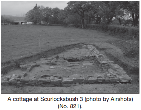
The foundation remains of a vernacular cottage, the partial remains of two outbuildings, and a cobbled pathway were recorded at Scurlocksbush 3. These remains were evident on the first-edition OS maps, with the inhabitants recorded in the 1911 census.
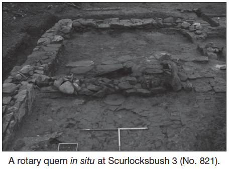
A two-roomed vernacular cottage, orientated north-east to south-west, was found. The rectangular structure had an average of three wall courses remaining. Large flat-surfaced stones were positioned on the exterior of the walls. Evidence of lime mortar was identified on the interior of the walls. Flagstones remained in situ on the floor. The remnants of a large open fireplace were recorded, which had later been altered with the addition of an underground pipe to assist in the circulation of airflow within the fireplace. A rotary quern fragment was inserted into the foundation of the fireplace to level the floor. A narrow corridor was evident on the southern side of the cottage which gave access to the ground floors. Several post-medieval finds, including nails, ceramic, tiles, clock remains and candlestick fragments, were identified.
A second structure, a probable outbuilding, was represented by the remains of a single portion of wall which was orientated north to south. The structure, which was located south-east of the main cottage, was constructed of random rubble. The largest stones of limestone with flat surfaces were placed on the exterior. Approximately three courses remained in situ. Lime mortar was used to bond the stones together. The external portion of the wall had collapsed on the south-east, revealing sand clay on which the wall was constructed. A later drain ran along the eastern edge of the wall.
To the east of the main cottage, a single north-west/south-east-orientated wall provided evidence of a third structure or a possible second outbuilding. The wall was constructed of very random rough coursed stones. The wall had a gap in the centre where cobbling and two flat stones at either side indicated an entrance. The interior floor of the structure was evident, with a small patch of stone cobbling identical to that at the entrance.
A wide cobbled path was recorded with a north to south orientation between the two outbuildings. This cobbled path curved north-west from the first outbuilding towards the main cottage. A portion of this pathway was also evident orientated east to west from the western side of the wall of the second structure. A narrow shallow slot-trench was located north of the second structure and encompassed a circular area measuring approximately 7.2m by 7m. It is possible that this represents a small stockyard, pen or corral for livestock.
A series of later post-medieval field drains, field-clearance pits and stone dumps were also identified on this site.