2010:747 - DRUMGOLD (1), Wexford
County: Wexford
Site name: DRUMGOLD (1)
Sites and Monuments Record No.: N/A
Licence number: E004200
Author: Derek Gallagher, for TVAS (Ireland) Ltd.
Author/Organisation Address: Ahish, Ballinruan, Crusheen, Co. Clare
Site type: House - Bronze Age, Structure and Pit
Period/Dating: Multi-period
ITM: E 699788m, N 639058m
Latitude, Longitude (decimal degrees): 52.493797, -6.530477
The site was located on the proposed M11 Gorey to Enniscorthy scheme in a crop field. The site included two circular Bronze Age houses, two palisade trenches and a series of pits and post-holes. The site occupied a narrow strip between the edge of the development site and an existing road and several features continued outside the limit of excavation.
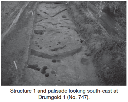
Structure 1
Approximately two-thirds of a penannular structure was excavated, with both the north-east and south-west sides lying outside the excavation area. The internal diameter was approximately 7.5m (north-west to south-east). The building was formed by slot-trenches with turned-in terminals and post-holes at the south-eastern entrance. The three lengths of slot-trenches within the site were 6.8m, 4.1m and 3.55m long, 0.57–0.87m wide and 0.22–0.4m deep. Within the interior of the structure were a number of post-holes, some of which represented roof supports, as well as a hearth that measured 1.2m by 1.1m and was 0.15m deep.
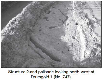
Structure 2
The second structure lay 7m north-west of Structure 1. Only approximately one-third of the structure lay within the limits of excavation. The north-east and eastern perimeter of the structure was recorded as a mix of slot-trenches and post-holes. Approximately 8.75m of the slot-trench was excavated and was seen to be 0.14–0.47m wide and 0.06–0.27m deep. Interspersed along the length of the slot-trench were a series of post-holes. A possible entrance was located on the eastern side of the structure where the slot-trench formed a widened terminal and a post-hole lay 1m to the south. Two large pits were recorded within the interior of the structure. These measured 1.01m by 0.78m by 0.33m and 1.8m by at least 0.5m by 1m.
Palisades
North-west and south-east of Structure 1 were two palisade trenches. The one to the south-east was orientated north–south and was approximately 10.7m long within the site, 0.51m wide and 0.4m deep. A 0.7m gap formed an entrance through the palisade, allowing access to the house, and post-holes were evident in the base of the northern palisade trench suggesting a large gate. Outside the palisade were two parallel lines of post-holes orientated east–west that led towards the entrance.
The second palisade trench to the north-west was continuous, with no entrance recorded. It was orientated east-north-east to west-south-west and was 0.5m wide and 0.4m deep with post-holes evident in its base. Running parallel was a smaller trench, 0.16m wide and 0.16m deep. All the trenches had near-vertical sides and flat bases and would have held substantial timber fences
A number of external pits, post-holes and stake-holes were recorded around the two structures. A large quantity of flint, prehistoric pottery (both decorated and undecorated) and a possible rubbing stone were all recorded from the site.