2010:742 - CORBALLY (4), Wexford
County: Wexford
Site name: CORBALLY (4)
Sites and Monuments Record No.: N/A
Licence number: E004241
Author: Colum Hardy, for TVAS (Ireland) Ltd.
Author/Organisation Address: Ahish, Ballinruan, Crusheen, Co. Clare
Site type: Burnt spread, Structure and House - prehistoric
Period/Dating: Multi-period
ITM: E 701325m, N 641102m
Latitude, Longitude (decimal degrees): 52.511875, -6.507234
Corbally 4 was located on the proposed M11 Gorey to Enniscorthy scheme. The site was situated in a field of barley. The field sloped gently from south to north and was bounded on three sides by mature trees, shrubs and bushes.
Burnt spread, trough and stake-holes
A burnt spread consisting of two deposits was uncovered at Corbally 4. The basal deposit was firm grey silt sand which contained moderate amounts of charcoal and heat-affected stone. This lower deposit measured 9.5m by 8.4m and was up to 0.24m thick. The upper deposit measured 8.4m by 6m by 0.2m and was soft black silt sand which contained a high density of charcoal and heat-affected stone.
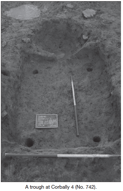
An east–west-aligned trough was identified beneath the spread. The trough was in two parts: a circular element with a concave profile at the west and a rectangular part with vertical sides and a flat base at the east. Four stake-holes were found, one in each corner of the rectangular section, and these presumably indicate that there was originally a timber lining. Overall the feature measured 2.84m by 1.98m and was 0.51m deep. A slight channel connected the circular and rectangular parts and, as the eastern end was slightly higher than the west, this would have allowed the natural flow of water down from the main body of the trough into the circular end. The trough contained five fills which spread across both the circular and rectangular parts, suggesting that they were contemporary. The upper fill of the trough was firm yellow/grey silt sand which contained charcoal flecks. Below this was firm brown/grey silt sandy fill which contained flecks of charcoal and heat-affected stone. Below this fill was a layer of grey/brown clay sand which contained moderate amounts of charcoal and heat-affected stones. The penultimate fill was firm grey clay sand with charcoal and heat-affected stones. The basal fill consisted of loose black sand which contained heat-affected stones and charcoal inclusions.
A group of 41 stake-holes was found adjacent to the eastern end of the trough. The stake-holes did not form a distinct shape and may represent the location of a windbreak which was regularly repaired or repositioned. An oval pit which measured 2.16m by 1.44m and was 0.31m deep was found immediately to the west of the trough. This pit had gradually sloping sides and a rounded base which contained two fills. The fills were firm grey silt sand which contained sub-angular stones and charcoal, which was concentrated towards the base.
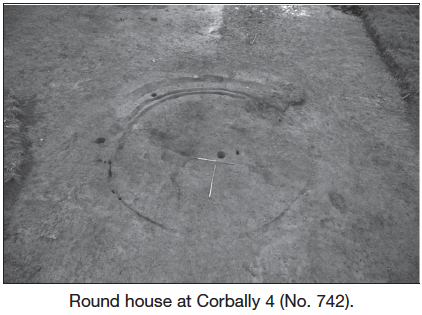
Round house
A circular round house was found to the north-west of the burnt spread. The circular structure had a diameter of 5.3m and was defined by three incomplete foundation trenches. The three main trenches were 3m, 5m and 7.9m long, 0.06–0.23m wide and 0.01–0.1m deep. The entrance appears to have been located at the north side, defined by a gap measuring approximately 1.6m between two of these foundation trenches. Four shallow stake-holes, 0.08m in diameter and 0.08m deep, were identified in a portion of the north-eastern foundation trench. Two post-holes were located east of the round house, which appeared to have aided in the structural integrity of the building. A central internal post-hole, 0.25m in diameter and 0.3m deep, was recorded, which possibly acted as a roof support. A single stake-hole was found adjacent to the post-hole. A large portion of the foundation trench was missing at the south-west, probably having been damaged during post-medieval stone clearance.
Two possible external drip gullies were found, which formed a parallel curvilinear alignment at the south-eastern perimeter of the structure. The inner gully measured 8m by 0.21m and was 0.14m deep, while the exterior gully measured 7.5m by 0.47m and was 0.23m deep.