2010:741 - CORBALLY (2–3), Wexford
County: Wexford
Site name: CORBALLY (2–3)
Sites and Monuments Record No.: N/A
Licence number: E004276
Author: Colum Hardy, for TVAS (Ireland) Ltd.
Author/Organisation Address: Ahish, Ballinruan, Crusheen, Co. Clare
Site type: Enclosure, Kiln - corn-drying, Pit and Field boundary
Period/Dating: Multi-period
ITM: E 701288m, N 641038m
Latitude, Longitude (decimal degrees): 52.511307, -6.507798
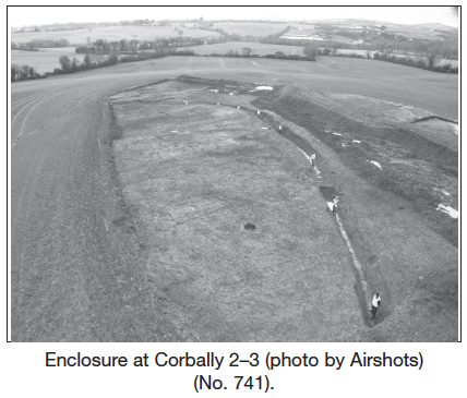
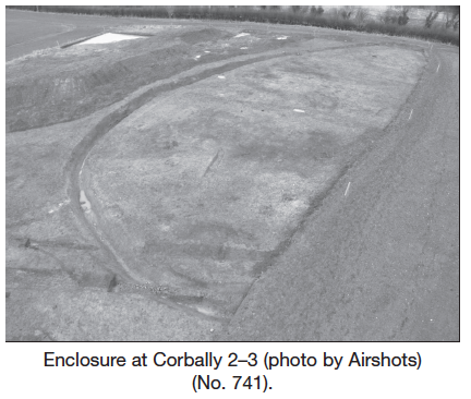
Corbally 2–3 was located on the proposed M11 Gorey to Enniscorthy scheme. The site was situated in a field which is level at its northern extent but slopes dramatically southwards, where again it changes to a gentle undulating slope. It is bounded by ditches, and hedgerows which are dominated by mature trees and gorse bushes. There are extensive views to the south, south-west and west towards Vinegar Hill.
Enclosure ditch
Approximately 50% of a subcircular enclosure, the western half, lay within the extents of the proposed new road. The enclosure was located on the crest of a hill which sloped down to the south and south-west. The excavated portion of the enclosure had a diameter of approximately 60m. The enclosure ditch was, on average, 2.53m wide and 1.25m deep with gradually sloping sides and a U-shaped profile. There was a 1m-wide entrance recorded at the north-west; however, there were no post-holes or evidence for any gate structure. The ditch contained seven to eight fills, which were a natural series of silting and backfilling, and there was no evidence of the ditch having been recut. Several kilograms of iron slag was retrieved from the enclosure ditch, the majority of which (approximately 90%) was recorded from the north-west portion, especially from the terminals, and it would appear that there was a deliberate deposition of waste iron slag material at the enclosure entrance. The slag was, however, recorded along the entire length of the ditch from all fills, although more was recovered from the second fill from the base. A small lens of charcoal was evident in some of the ditch sections and a small amount of burnt bone was recorded in the southern portion. Artefacts from the ditch were sparse, but some sherds of possible early medieval pottery, a possible loom weight and a small anvil or head of a blacksmith’s hammer were recovered. The latter item will require x-raying to confirm its function. There was no surviving evidence of a bank on either side of the enclosure ditch, although this may be the result of intensive agriculture in recent years.
Enclosure interior
Few features were identified within the part of the enclosure interior that lay within the limit of excavation. A large circular pit, 0.93m across and 0.35m deep, had vertical sides and a flat base. The pit contained two fills which were loose mid- to dark-grey stony, silty clay which contained iron slag, traces of burnt bone and charcoal flecks. Two smaller pits and three associated stake-holes were also recorded. An oval pit, measuring 0.53m by 0.44m and 0.23m deep, had gradually sloping sides and a flat base. This pit was filled by mottled orange/brown clayey sand. An adjacent, oblong-shaped pit, which measured 1.04m by 0.6m and was 0.3m deep, contained four fills. The fills consisted of loose mid-brown/black silty clay which contained traces of burnt bone and a concentration of charcoal in the central fills. A saddle-quern fragment was retrieved from this pit.
Exterior to enclosure
A number of isolated features were identified external to the ditch. A concentrated deposit of iron slag was identified to the south-west, close to the edge of the ditch, indicating a possible ironworking area. The deposit measured 2.3m by 1.2m and was 0.12m deep and consisted of charcoal-rich mid-grey/black clay silt containing burnt clay, heat-affected stones and iron slag.
An isolated subcircular pit measuring 1.3m by 1.26m and 0.27m deep which had gradual sides and a flat base, was found to the west of the enclosure. The pit had a single fill which was medium compacted dark-red/grey sandy clay which contained a small quantity of iron slag. A large oval hearth was also recorded to the exterior of the enclosure. The hearth measured 2m by 1.8m and was 0.12m deep with gradual sloping sides and a flat base. Six fills were recorded, which were all quite thin and were a mix of charcoal-rich layers, red scorched earth and friable dark-grey/brown silt clay. Two conjoined subcircular pits were recorded south of the enclosure. The western pit measured 0.94m by 0.93m and was 0.14m deep, whilst the eastern pit measured 1.36m by 1.26m and was 0.15m deep. Two stake-holes were recorded, one of which truncated one of the pits.
Cereal-drying kiln
Outside the southern edge of the enclosure an east–west-oriented cereal-drying kiln was uncovered. The kiln was an elongated S-shape in plan, measured 7.66m in length and sloped upwards from west to east from the fire hearth to the drying chamber. The drying chamber, which was 1.44m wide and 1m deep, was located at the east side. The hearth, or fire bowl, was located to the west and was 1.5m wide and 0.35m deep. The flue was approximately 3m long. The fire bowl appeared to have been partially lined by stones. There were two stones placed at the entrance to the flue, which acted as possible baffle stones, preventing any sparks from the fire entering the flue, travelling up to the drying chamber and setting the cereal alight. The fire bowl had two distinct charcoal-rich layers separated by an orange/brown oxidised layer of silty clay produced by intense burning. The flue and lower layers of the drying chamber were filled with loose mid-brown sandy clay with approximately 10% charcoal inclusion and a loose mid-brown/black sandy clay with 50% charcoal inclusions.
Post-medieval ditches
Two linear ditches truncated the enclosure ditch along its southern perimeter. These ditches were orientated east–west, sloping downhill, and were 35–40m long within the excavated area. The ditches were 1.5m wide and 0.26–0.36m deep with gradual sloping sides and a U-shaped profile. One ditch appeared to have been recut and both were later truncated by a French drain. A third shallow linear ditch/drain on the same alignment was identified within the interior of the enclosure. This feature was recorded for a length of 28m and was 0.8m wide and 0.22m deep with a U-shaped profile.
Prior to the analysis of samples for dating, the site appears to represent an early medieval enclosure with evidence of large-scale and frequent metalworking. Geophysical survey exterior to the limit of excavation (by Jo Leigh, licence C233) revealed a number of large responses which may represent additional metalworking activity.