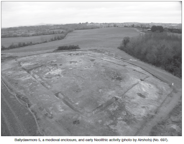
2010:697 - BALLYDAWNMORE (5), Wexford
County: Wexford
Site name: BALLYDAWNMORE (5)
Sites and Monuments Record No.: N/A
Licence number: E004171
Author: Leigh Barker, for TVAS (Ireland) Ltd.
Author/Organisation Address: Ahish, Ballinruan, Crusheen, Co. Clare
Site type: Cairn, Cremation pit and Enclosure
Period/Dating: Multi-period
ITM: E 701108m, N 641769m
Latitude, Longitude (decimal degrees): 52.517907, -6.510226
Ballydawmore 5 was located on the proposed M11 Gorey to Enniscorthy scheme. The site was located on a low sandy kame at an elevation of 39.5m OD in Ballydawmore townland, Co. Wexford, with views over the Slaney valley towards the Blackstairs Mountains. A canalised stream bounded the north and east of the site.
Test-trenching at Ballydawmore 5 in May 2010 revealed a concentrated circular spread of large sub-rounded boulders on the centre of the low hill. The boulders averaged 0.2–0.3m in size and formed a spread that measured 4m in maximum diameter. The spread of boulders was identified as a possible small stone cairn. Only a single layer of these stones was evident, though test excavations did not probe deeper than c. 0.15m. Several lithics, including a flint core and debitage, were recovered in proximity to the possible cairn. Several ditches were also encountered in test-trenches and appeared to form a circuit around the possible cairn.
Cleaning of the site was undertaken over four weeks in June/July 2010 covering an area of 4246m². In addition to the previously identified cairn, a rectangular enclosure was apparent (comprising the ditches recorded during testing). The enclosure was orientated north-north-west/south-south-east with internal dimensions of approximately 28m by 25m. The ditch was found to have a narrow V-shaped profile with a maximum depth of 1.1m. A large causeway, approximately 10m across, functioned as an entrance on the northern side of the enclosure. Aligned with the enclosure, a series of thinner and shallower linear ditches formed an apparent annexe to the enclosure, with only the western and north-western sides preserved.
A large number of additional pits, post-holes and linear features were also recorded. Finds from this stage comprised a few dozen lithics which were mostly recovered from the hand-cleaning of the surface of the site.
Full excavation of the site began on 4 October 2010 and was completed by 28 January 2011.
The first stratigraphic phase of the site is preliminarily identified as the construction of a large rectangular stone-lined probable cist overlain by a stone cairn. The only find to come from the cist was a large (85mm) leaf-shaped projectile point suggesting an early Neolithic date, though it may be a residual artefact. The cist comprised a large pit with a thick lining of sub-rounded and sub-angular boulders, some of which were large and thin enough to be used as uprights. The stones formed a chamber measuring 1.5m north-north-west/south-south-west by 1m internally and up to 0.7m deep. Two slot-trenches with packing stones were found at each end of the base of the chamber, beneath the stone lining, suggesting the chamber was also possibly originally lined with timber planking. Charcoal was recovered from secure contexts within the base of the cist and should provide an absolute date. No burial was encountered in the chamber, which was filled with redeposited sand, possibly as a result of collapse.
A second phase was represented by a later possible cremation pit, inserted into the top of the centre of the cairn. This appears to have been a short linear pit with the base partly lined with a large quartz slab and the sides lined with sub-rounded and sub-angular boulders, presumably reused from the original cairn. These surrounded blackish charcoal-rich soil which contained only a few specks of burnt bone.
Approximately 5m west of the cairn a cluster of stake-holes, possible post-holes and pits was centred on an area approximately 10m in diameter. No discernible pattern could be established, but in the centre of the area a small shallow pit was identified as a possible cremation burial-pit. The base of this pit was lined with a number of small flat pieces of shale, on which was deposited a black charcoal-rich material with a few fragments of burnt bone. This area was found to be particularly rich in lithics and might be identified as the focus of flint knapping on the site. The date and phase of the features is at present unclear.
A third phase on the site is represented by a medieval enclosure and annexe. A small number of sherds of pottery were recovered from the fills of the rectangular enclosure ditch and were identified by Niamh Doyle as Leinster cooking ware or a local derivative. At the terminus of the western entrance to the annexe to the enclosure, an entire large pot of identical pottery appears to have been broken in situ.
Immediately north-east of the entrance to the enclosure was an area with over 30 intercutting large pits and other features. A single piece of degraded middle Bronze Age pottery (Eoin Grogan, pers. comm.) was recovered from one of these pits, but may be residual given its condition. This area was particularly prone to animal disturbance, which was encountered across the site.
The final phase of activity comprised sets of post-medieval agricultural furrows which were orientated in three directions. They appeared to be hand-excavated cultivation furrows with a wide shallow profile and a separation of approximately 1.8m.
Around 300 lithic objects were recovered from the site; the majority of these were debitage and flint blades, but the assemblage also included three projectile points and a small number of flint cores along with a few scrapers. Residual flint artefacts were also recovered from many later features. The assemblage has been preliminarily identified as early Neolithic.

