2010:851 - LONGOFRDPASS BOG, Tipperary
County: Tipperary
Site name: LONGOFRDPASS BOG
Sites and Monuments Record No.: N/A
Licence number: 10E0332
Author: Jane Whitaker
Author/Organisation Address: c/o IAC Ltd, Unit G1 Network Enterprise Park, Kilcoole, Co. Wicklow
Site type: Road - class 2 togher
Period/Dating: Bronze Age (2200 BC-801 BC)
ITM: E 622522m, N 661388m
Latitude, Longitude (decimal degrees): 52.703149, -7.666758
Archaeological excavations in Kilmakill and Longfordpass North townlands in Longfordpass Bog, Co. Tipperary were undertaken as part of the 2010-2014 Peatlands Archaeological Mitigation Project. Excavations took place between 16 August and 17 September 2010.
This plank togher was located on the north-western side of the bog and at the time of the 2006 Peatland Survey it was visible, in the drain faces and on the bog surface, at six sightings. It was orientated north-west/south-east and was composed of longitudinally laid oak planks and roundwoods.
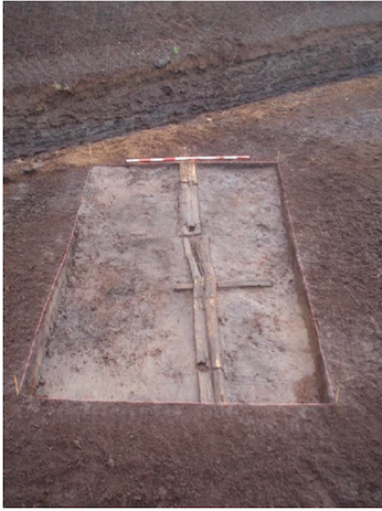
This Road-Class 2 togher was of single plank track construction dating to 1559±9BC. It was composed of longitudinal planks laid end to end and supported by occasional short transverse planks. No pegs were noted in any of the three cuttings excavated but mortice holes were recorded on three of the timbers. The wood exposed in Cutting 1 was badly disturbed by the milling process but Cuttings 2 and 3 clearly showed the construction method. The peat indicated the presence of several pools along its surviving length of 60m. It is possible that this site initially crossed the entire width of this part of Longfordpass Bog as it is the narrowest part of the bog but no further sightings were located during the 2010 season.
Three cuttings measuring 3m by 5m in size were excavated.
The site of Cutting 1 was entirely exposed on the field surface and had been badly disturbed by machinery. Only fragmentary pieces of oak planks remained, the most intact of which was located at the south-eastern extent of the cutting. This element measured 0.22m in width and had a triangular shaped mortice measuring 0.08m by a maximum of 0.06m in size.
Cutting 2 had a single, longitudinal, radially split oak plank which formed the upper walking surface of the togher. This was supported by a single transverse oak plank. The longitudinal plank was damaged by machinery and split along its length but measured c. 0.28m in width, 0.07m in depth and was exposed for a length of 4.8m within the cutting. The transverse plank, located at the western extent of the cutting, measured 0.16m in width, 0.05m in depth and 1.21m in length. Wood chips were noted alongside the longitudinal plank but these appeared to have been the result of machine damage rather than indicating wood working in situ.
In Cutting 3 two longitudinal planks laid end to end were exposed, both of which contained mortice holes. The western plank measured 0.09m in width, 0.05m in depth and 3.16m (min.) in length. It had two incomplete mortices which were sub-rectangular in shape and measured 0.1-0.14m x 0.12m in size. The eastern plank measured 0.12m in width, 0.06m in depth and 1.25m (min.) in length. This plank had a single intact sub-rectangular mortice at its western end which measured 0.06m by 0.1m in size. A single radially split transverse supporting timber was revealed in this cutting underneath the western timber. It measured 0.12m in width, 0.05m in depth and 1.25m in length. This timber had a triangular notch cut into its side.
Please see final report:
Whitaker, J. 2021. Final Excavation Report for Longfordpass Bog (Licences: 10E0330, 10E0331, 10E0332, 10E0333), Irish Archaeological Consultancy Ltd., 2019. Unpublished report prepared by IAC Archaeology.