2010:538 - ROSSNAREE, Meath
County: Meath
Site name: ROSSNAREE
Sites and Monuments Record No.: ME019–080
Licence number: 10E0242
Author: Conor Brady, Department of Humanities, Dundalk Institute of Technology, Dundalk, Co. Louth.
Author/Organisation Address: —
Site type: Enclosure and Prehistoric site - lithic scatter
Period/Dating: Prehistoric (12700 BC-AD 400)
ITM: E 698254m, N 772156m
Latitude, Longitude (decimal degrees): 53.689870, -6.512373
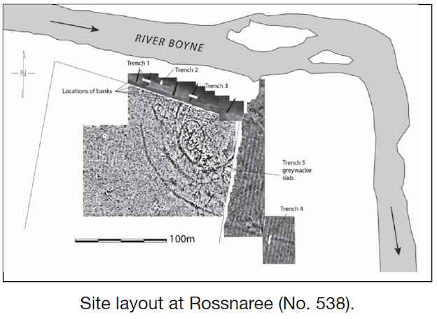
The site was first discovered as a lithic scatter close to the southern bank of the River Boyne, at the westernmost point of the ‘Bend of the Boyne’. Subsequently geophysical surveys, funded by the Heritage Council, revealed the presence of a substantial D-shaped multivallate enclosure which measures c. 300m east–west by c. 150m. The enclosure is bounded on the north and east side by the River Boyne. The core of the enclosure and the main area of activity are focused on a small but distinct topographic rise located on the first fluvioglacial terrace overlooking the flood-plain proper of the River Boyne.
The key aim of the excavation was to retrieve material suitable for dating, to assess the archaeological potential and preservation of subsurface remains at the site and also to explore some of its functions. Four cuttings were excavated and, although a fifth (Trench 2) was planned, this was not opened. Trenches 1 and 3 were located on the sloping face of the fluvioglacial terrace mentioned above, an area that has never been cultivated and with preservation of archaeological stratigraphy commencing immediately below the sod/topsoil layer. Trench 4 was positioned in the flood-plain to the east and Trench 5 was opened around a greywacke slab partially exposed on the surface of the same pasture field close to the field boundary. Greywacke is the stone type that was used in the construction of many of the passage tombs on the northern side of the river and is not local to the area.
Trench 1 was located on the north-facing slope of the fluvioglacial terrace, an area untouched by cultivation. The features investigated here included part of the bank of the outer enclosure in the eastern end of the trench and its associated ditch immediately to the west. Three metres further to the west of this is a smaller ditch feature. The main ditch at the east end of the cutting was V-shaped in profile and reached an overall depth of 1.47m below sod. The mandible of a cow was recovered from the fill at the base of this feature. A number of possible recuts were discernible in the section. Occasional finds included animal bone and pieces of flint. A smaller ditch was recorded c. 3m further to the west. As this feature diverges from the line of the main ditch as it descends the slope, it may not be associated with it. This small ditch had a V-shaped profile with a depth of c. 0.8m and a width at the top of c. 1.5m and had three main fills.
Trench 3 was located on the same north-facing slope as Trench 1. As with Trench 1 this area was unaffected by cultivation and preservation was very good. The main features in this trench were the bank and ditch. The ditch, on excavation, was smaller is scale than the main ditch in Trench 1 with a width of c. 2m at the top and a depth of c. 1m. A cow rib was excavated from the very base of this ditch and hopefully will provide a suitable sample for radiocarbon dating. There was a recut towards the base of the ditch. The bank was very solidly constructed with a core of large, well-placed cobbles and was c. 2m wide with a depth of c. 0.8m. A cow skull was found inverted within the stones of this feature and was clearly a deliberate incorporation. Abutting this feature was a rich silty humic layer of material with frequent pieces of animal bone and flint. Below this layer and the bank was another relatively stone-free rich humic layer. Chronologically diagnostic artifacts were recovered from below the bank: a fragment of a double-sided bone or antler comb and a copper-alloy strap. These finds provide a terminus post quem for the bank feature above and indicate that it is likely to have a late first-millennium AD date. Beneath this layer, a linear stone terracing or revetment feature comprising at least three courses of substantial cobbles was found. The feature ran roughly horizontally across the face of the slope for a distance of c. 4.5m within the trench and appeared to continue eastwards out of the area of the trench.
Trench 4 was positioned to investigate the outer enclosure ditch at the level of the river flood-plain. It was clear that this area had been cultivated in the past and, on excavation, it was established that the depth to undisturbed natural was c. 0.45m. The ditch was c. 3.6m wide and was at least 1.5m deep below sod level. It was not possible to establish the exact base of the ditch because of flooding. Five distinct fills were encountered during the excavation and material from a possible levelled internal bank was identified. Occasional flint artifacts and animal bone fragments were recovered.
Trench 5 was positioned to investigate the area of a greywacke slab which appears to have been displaced during cultivation. Excavation of the cultivation soil was conducted until the base of the greywacke slab was exposed. This was found to be lying completely within the cultivation soil layer and appears to have been moved to its current position in relatively recent times. Excavation ceased at this point so as not to destabilise the stone in advance of raising it. At the north end of the trench a possible deliberate linear setting of firmly set field stones was uncovered. Their function is unclear at present. Fragments of barbed-wire fencing were frequent and some animal bone was also recovered. Occasional lithic artifacts were also encountered as well as a portion of a lignite bracelet.
The major features at this site appear to be early medieval in date. No structural evidence of the intense prehistoric activity indicated by the lithic scatter came to light and the exact nature of this activity remains to be determined. The funding support provided by the National Monuments Section, Department of the Environment, Heritage and Local Government, on the recommendation of the National Committee for Archaeology of the Royal Irish Academy, is gratefully acknowledged.