2010:528 - MONKNEWTOWN, Meath
County: Meath
Site name: MONKNEWTOWN
Sites and Monuments Record No.: ME019–015
Licence number: 10E0477
Author: Conor Brady, Department of Humanities, Dundalk Institute of Technology
Author/Organisation Address: Dundalk, Co. Louth
Site type: Ritual site – pond
Period/Dating: Neolithic (4000BC-2501 BC)
ITM: E 699229m, N 775519m
Latitude, Longitude (decimal degrees): 53.719899, -6.496543
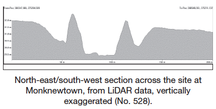
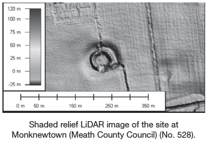
The site is described as a ‘ritual site – pond’ and is referred to as Site W in the Brú na Bóinne complex (O’Kelly 1978). It is located c. 2km north of Newgrange passage tomb in the northern buffer zone of the Brú na Bóinne World Heritage Site and is close to Monknewtown Henge (Site V) and passage tomb (Site S).
Owing to the proximity of the monument to extensive known Neolithic archaeology both at Brú na Bóinne and Monknewtown, it has previously been suggested (Meenan 1997; Condit and Simpson 1998, 59–62) that Site W may also date from this period. Monknewtown Pond has also been compared to the similar Late Bronze Age site of the King’s Stables in the Navan complex in County Armagh (Lynn et al. 1977). The Monknewtown site is very similar to but slightly larger than the King’s Stables. The Monknewtown site has an additional wide, deep external ditch, with an average width of c. 10m and depth of 1.5–2m. Based on its location (in particular its proximity to the Monknewtown Henge, Site V) and comparison with the King’s Stables, it has been suggested that Site W is likely to be a ritual site.
Two further ponds exist in the fields to the south of the main passage tomb at Newgrange (ME019–067003 and ME026–021002) and at least one of these seems to be artificial, based on its shape. Another possibly similar site in the field immediately to the south of Site W, although currently quite overgrown, may be a similar site. None of these features has been extensively investigated.
The investigation described here was a small-scale augering programme undertaken as part of the wider INSTAR-funded Boyne Valley Landscapes project. The work involved the retrieval of a series of soil cores spaced at 5m intervals across the outer ditch of the site. The aims of the project were to examine the stratigraphic profile of the monument at various points, to establish a date of initial construction for the monument and identify possible phasing in its use and to retrieve suitable samples for a variety of environmental analyses.
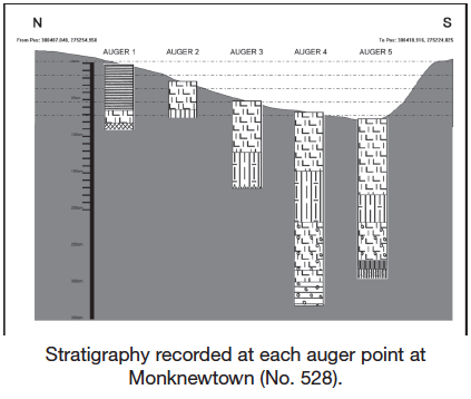
Subsequent to an extensive preliminary programme of geophysical investigation, augering was carried out across the external ditch of the monument on its northern side. Although it had been planned to take samples along two separate transects, one running north–south and the other running east–west, bisecting the monument and intersecting in the interior, this was not possible at the time of the fieldwork because of the high water levels in both the pond in the interior and the surrounding ditch.
Preliminary stratigraphic assessment utilised a narrow-chamber (25mm) gouge and was undertaken along the northern side of the planned north–south transect as described above. It was possible to sample and record stratigraphic information at five separate points: (i) at the top break of the slope of the ditch, (ii) at the midpoint of the slope of the ditch, (iii) at the base of the slope, (iv) at the midpoint of the ditch (depth of standing water in ditch 0.23m), (v) at the junction of the ditch and the base-of-slope of the inner bank.
Stratigraphy was good from the five samples. Points 4 and 5 were particularly deep (2.56m and 2.39m respectively) and seven separate layers were recorded in each. A layer of organic-rich material was encountered at auger point 5 between a depth of 1.93m and 2.09m, possibly representing the base of the ditch. Given the potential of the material from this layer, a core sample was retrieved.
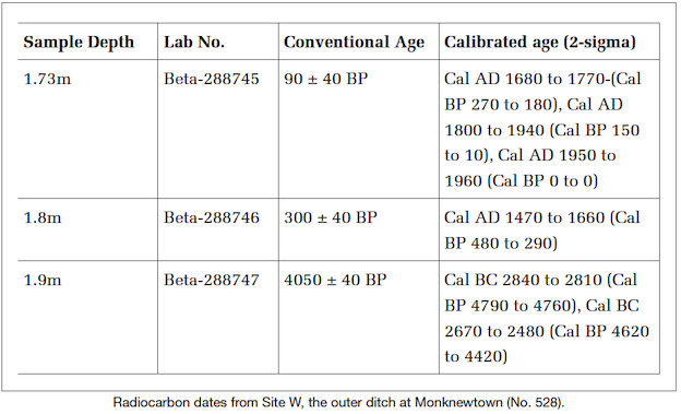
Material for dating has been submitted to Beta Analytic for radiocarbon dating and three were successfully dated. The upper two dates at 1.73m and 1.8m (Beta–288745 and Beta–288746) proved to be post-medieval, dating to 90±40BP and 300±40 BP respectively (see table). These are presumably related to the retting activity highlighted by O’Kelly (1978). However, the lowermost date (1.9m – Beta–288747) returned a late Neolithic date (4070±BP), broadly equivalent in date with the south-eastern pit circle at Newgrange and the grooved ware circle at Knowth (see dates in Smyth et al. 2009). It is intended that an additional date be obtained from the lower portion of the core to verify this date, and samples from the lower portion will be examined for pollen preservation.
Preliminary palaeoenvironmental assessment carried out by Dr Stephen Davis (School of Archaeology, UCD) has confirmed the presence of plentiful organic material, almost entirely comprising short sections of waterlogged straw-like matter, not unlike decomposed herbivore dung. Few clearly identifiable plant macrofossils were evident, although some fruits of Polygonaceae (dock family) were present, as were, in the uppermost sample, a single seed of Glyceria sp. Insect remains were also sparse, but the lower levels included two staphylinids of the genus Anotylus (A. rugosus and A. nitidulus), both of which are common taxa of decomposing plant matter.
Although small in scale, this project has yielded very valuable information on the dating of this unusual site, clearly confirming the likelihood that it was first constructed during the late Neolithic period. Thus, it is now possible to regard this monument as a key component in the prehistoric landscape of the Brú na Bóinne area.
References
Condit, T. and Simpson, D.D.A. 1998 Irish hengiform enclosures and related monuments: a review. In A. Gibson and D.D.A. Simpson (eds), Prehistoric ritual and religion, 32–44. Stroud.
Lynn, C.J., Penn, C., McCorry, M., Delaney, M. and Larmour, R. 1977 Trial excavations at the King’s Stables, Tray Townland, County Armagh. Ulster Journal of Archaeology 40, 42–62.
Meenan, R. 1997 Monknewtown ritual pond. In T. Condit (ed.), Brú na Bóinne, a supplement to Archaeology Ireland 41, 23.
O’Kelly, C. 1978 Illustrated guide to Newgrange and the other Boyne monuments. Cork.
Smyth, J., Brady, C., Chadwick, J., Condit, T., Cooney, G., Doyle, I., Guinan, L., Potterton, M., Stout, G. and Tuffy, C. 2009 Brú na Bóinne world heritage site research framework. Dublin.