2010:457 - BARNAVEDDOGE, Louth
County: Louth
Site name: BARNAVEDDOGE
Sites and Monuments Record No.: LH017–036
Licence number: 10E0069
Author: Kieran Campbell
Author/Organisation Address: 6 St Ultans, Laytown, Co. Meath
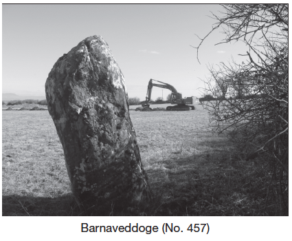
Site type: Ogham stone
Period/Dating: Iron Age (800 BC-AD 339)
ITM: E 699987m, N 789464m
Latitude, Longitude (decimal degrees): 53.845024, -6.480544
Planning permission was granted by Louth County Council for the retention of quarry activities and to construct a new vehicular entrance from the R170 Ardee to Dunleer road. An assessment, carried out as a condition of planning permission, comprised a geophysical survey and test-trenches. The quarry occupied an area 163m east–west by 165m, most of which had already been worked, in places to a depth of 10m. The proposed access road was to be 135m long with a land-take width of 15m and was to run from the R170 road starting at a point 35m east of LH017–036, ‘Standing Stone’. The standing stone is indicated as ‘Stone’ on the first edition of the OS 6-inch map published in 1836, and as ‘Standing stone’ on later editions. Professor R.A.S. Macalister, in the County Louth Archaeological Journal for 1915, states that the stone bears an ogham inscription reading ‘BRANOGENI’, meaning ‘raven-born’.
Another monument, LH017–035, a mound (site), is 50m west of the standing stone, in the adjacent field, and is indicated as an antiquity, ‘Mound’, on the 1938 6-inch map. The Archaeological Survey of County Louth suggests that the mound was a possible megalithic tomb (Buckley and Sweetman 1991, 41). However, the 1995 OS aerial photographic survey on www.osimaps.ie, clearly shows the cropmark of a double-ditched enclosure c. 60m in diameter. There is nothing visible on the ground but the site presents as a platform with a slightly dished centre.
A geophysical survey, conducted by J.M. Leigh Surveys (licence 10-R–25), identified numerous amorphous responses of archaeological strength throughout the data set but no archaeological pattern could be identified, and the interpretation was that natural features were represented. Certain responses were tentatively identified as possible ditch- or pit-type features.
Trench 1, excavated on 11 March 2010, was a continuous 1.85m-wide trench excavated for 135m along the centre line of the access road. Trench 2, 20m long, was excavated in an undisturbed area at the south-east corner of the proposed quarry. Undisturbed subsoil was uncovered for most of the length of the test-trenches. Two ditches, 1.2m and 1.6m wide, 80m apart and each aligned south-west/north-east, were recorded crossing the route of the access road. No finds or other inclusions were noted in the brown sandy clay fill, which contrasted with the stony subsoil. The ditches may represent field divisions pre-dating the present layout, which is unchanged since the 1836 OS survey, and are possibly associated with the cropmark enclosure nearby. A recommendation was made that monitoring be carried out during topsoil-stripping for the access road.