2010:421 - KILKENNY: Talbot’s Tower, Ormond Road, Kilkenny
County: Kilkenny
Site name: KILKENNY: Talbot’s Tower, Ormond Road
Sites and Monuments Record No.: KK019–026
Licence number: E3646; C240
Author: Cóilín Ó Drisceoil, Kilkenny Archaeology
Author/Organisation Address: Threecastles, Kilkenny
Site type: Town defences
Period/Dating: Medieval (AD 400-AD 1600)
ITM: E 650439m, N 655653m
Latitude, Longitude (decimal degrees): 52.649732, -7.254586
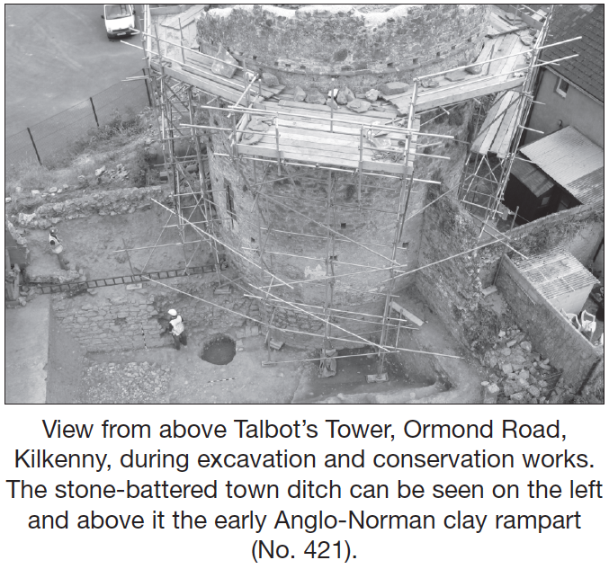
A second and final phase of excavation was carried out at Talbot’s Tower, the south-west angle of the city’s medieval Hightown fortifications (Excavations 2007, No. 967). The excavation was a research exercise which formed part of a programme of conservation measures for the tower and walls that are being guided and developed by the Kilkenny City Walls Steering Committee and funded by the Irish Walled Towns Network Fund and Kilkenny Borough Council. The excavations occurred in tandem with an archaeological building study carried out by Ben Murtagh. The tower was strategically sited to take advantage of a low hill and from its parapets there are extensive views in all directions, making it an extremely effective watchtower. The tower was known throughout the medieval period as ‘St Patrick’s Tower’ in reference to the nearby suburb of Domhnachpatrick. In the 19th century it was known as ‘Watter’s tower’. The name ‘Talbot’s Tower’ is an early 20th-century invention that alludes to Robert Talbot, who was mayor of Kilkenny in the early 15th century and was traditionally credited with building the city’s walls. The tower stands to 9.7m in height, is 5.6m diameter internally and its walls, which are 1.65m thick, slope to the bottom of the town ditch. The structure that can be seen today is an amalgam of at least three different building episodes.
Before the stone tower was built, a timber tower on the corner of an earthen rampart stood in its place. This was probably built around 1200 by the then lord of Leinster William Marshal. It was William’s grandson Gilbert de Clare who was responsible for replacing the earth-and-timber defences with a larger and stronger stone circuit. The first stone tower was built at this time and was an open-backed turret with a battlemented parapet and a wooden roof. In the 1400s the back of the tower was filled in and the structure was heightened by placing a domed roof over the older battlements. A well-preserved example of wicker centring—the wooden framework which supported the vault during its construction—can still be seen inside the tower. Access to the top of the roof was gained by a stone stairs that ran inside the wall. There were no major modifications to the tower until the 1700s, when its parapets were remodelled to make the tower appear as a garden folly.
Excavations in 2010 focused on completing the cutting started in 2007 in the town ditch and the excavation of a cutting in the earthen rampart on the east side of the ditch to accommodate a foundation for the rebuilding of a section of the wall that had fallen in 1989, and finally the removal of the earthen ‘garden mound’ on top of the tower. A 10m-long stretch of the town ditch was excavated and found to be 5m wide x 1.5m deep. Its inner edge was protected by a sloping stone wall, a ‘base batter’, that prevented attackers from tunnelling beneath the wall. Excavation of the ditch also uncovered the bottom quarter of Talbot’s tower and it too was found to have a thick base batter. Sections of the original lime-mortar render were found adhering to the tower, reminding us that the town walls would have appeared ‘white-washed’ in the Middle Ages. The town ditch was filled with many different layers of soil, some of which had naturally silted into it and some of which had been deliberately dumped. During the medieval period the ditch would have been cleaned out intermittently, although it was never completely emptied, which left layers of soil towards the bottom of the ditch that date from the 13th century. The ditch would also have been used by the townsfolk as a refuse dump and this is probably where the vast majority of the large quantity of artefacts and animal bones derived from. At the very base of the ditch a rough stone path was found. This was put in place as a solid surface that could be worked upon when construction was taking place on the tower. Patches of mortar, chips of stone and nails were all found in amongst the stones of the path. One layer within the ditch was particularly interesting. This was right up against the wall of the tower and contained numerous pieces of lead musket shot which had been fired at the tower, probably during one of the 16th-century sieges of Kilkenny. By the mid-18th century the town defences had become somewhat obsolete and the town ditch at Talbot’s Tower was fully backfilled and closed over. In 1816 Ormonde Road was built to link Patrick Street with the Callan Road. This cut a large swathe through the town wall, although its ditch is still likely to survive beneath the road.
The second cutting was excavated into the rampart that sloped up from the town ditch. It measured 8m x 3m and was excavated to the level of the glacial subsoil at 2.7m depth. An old ground level overlay the subsoil, from which a fragment of a (Lambay?) porphyry polished stone axe and a retouched scraper were recovered. Cereal grains from the deposit were radiocarbon dated to cal. AD 710–890 (UBA–1022). A low north–south-running earthen bank composed of redeposited sod overlay this layer and was either a pre-Anglo-Norman boundary or represented a formation bank for the early 13th-century rampart. The rampart itself was formed by the layering of clay and gravels that were excavated from the ditch below to form a 9m wide x 2.2m high rampart, which was presumably topped with a timber palisade. The only finds from the rampart were Leinster cooking ware sherds and iron nails. Pottery (Redcliffe, Kilkenny-type) from layers sealing the rampart indicates it preceded the construction of the stone defences by about fifty years.
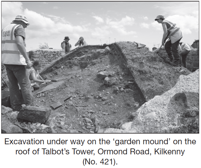
At the top of the tower was a 5m-diameter ‘pudding’-shaped mound of clay which covered the medieval roof of the structure. When excavated it was found to have been put in place in the late 18th-early 19th century to cover a large gouge that had been made into the structure of the original 15th-century roof of the tower. The sod layer which covered the mound contained a multitude of artefacts that showed how the top of Talbot’s Tower was used over the past two hundred years. Finds included fragments of Victorian wine bottles, clay tobacco-pipes, hair pins, lace chapes and many ladies’ buttons all attesting to the use of the roof as a place for particularly pleasurable types of recreation! Of interest also were a number of .303 bullets and cases, which may have been used by Free State forces against the Republican occupation of Kilkenny Castle during the Irish Civil War. The 15th-century roof of the tower was basically a dome that was paved with fine stone flags. The flags had been robbed from the central dome of the roof, revealing the stone rubble core beneath. This was constructed using alternating layers of loose stone rubble and mortared masonry, probably to a thickness of c. 0.75–1m. Conservation and reconstruction works will continue in 2011 with a view to opening the site as a ‘town wall archaeological park’ in 2012.