2010:287 - CARDIFFSBRIDGE, Pelletstown, Dublin
County: Dublin
Site name: CARDIFFSBRIDGE, Pelletstown
Sites and Monuments Record No.: N/A
Licence number: 06E0934 ext.
Author: Edmond O’Donovan, Irish Archaeological Consultancy Ltd
Author/Organisation Address: 120b Greenpark Road, Bray, Co. Wicklow
Site type: Brickworks, Road - hollow-way, Weir- regulating and Castle - tower-house
Period/Dating: Multi-period
ITM: E 713366m, N 737736m
Latitude, Longitude (decimal degrees): 53.377631, -6.296142
Test excavation was carried out on behalf of Dublin City Council at the proposed new Cardiffsbridge Park in Pelletstown, Finglas, Co. Dublin. The testing sought to assess the impact of the development of the park on archaeological sites within the western half of the site.
This assessment forms the second phase of testing and follows on from earlier testing carried out at the eastern end of the proposed park by The Archaeological Company Ltd (06E0934). This revealed features associated with 19th-century ironworks south of the river corresponding to anomalies identified in a geophysical survey.
The Phase 2 assessment was undertaken in November 2010 and involved the excavation of 3978 linear metres of test-trenches within four test areas (Areas 1–4). Nine archaeological sites were discovered during the course of the works and included the remains of the Cardiffsbridge Castle (DU014–074) with possible associated ditches and pits.
Brick manufacturing deposits and the hollow way
Post-medieval brick manufacturing deposits dating from the 18th century were uncovered in three locations in Areas 2 and 3 on-site. These consisted of deposits of crushed red brick mixed with bands of charcoal and black clay between 0.3–0.9m deep. The deposits were spread over an area of between 10–20m in diameter and included fragments of coal and shell (oyster).
Evidence of a hollow way or old road (marked on the first-edition OS map as a field boundary) was located at the eastern end of the trenches in Area 3. The road was close to the existing field boundary and marked, prior to testing, by a raised bank on the west side. The roadway was c. 5–8m in width, c. 80m in length, and may have connected the River Road to the mill-race channel of the Tolka. The base of the road was approximately 1m below existing ground levels with a loose surface of stone and gravel compressed into the subsoil. The sunken area was filled with pieces of broken masonry, stone, pebbles and occasional spreads of fired clay and red brick.
The masonry rubble may have come from the ruins of the old castle (DU014–074) located in the field to the east or, more likely, from the same or similar quarried stone also used to build the boundary wall separating the fields from the River Road. No pieces of distinctive dressed stone from a building were recovered.
The road may have been used as a haul road servicing the brick clamps found in the test-trenches (see above) to the west of this area or during the construction of the mill-race. However, it possesses a hollow characteristic, which suggests that it may be older in date and represent a route that crossed the River Tolka to the north, prior to the establishment of the demesne landscapes that are associated with Sribblestown and Scripplestown Houses.
Mill-race channel
A stone-walled weir and paved cascade partially survives at the western end of the mill-race. The weir is illustrated on the first-edition OS map and consists of a wall that originally cut across the river and channelled water down the mill-race. Excess water would have cascaded over the weir and this cascade was originally paved. The weir wall has been removed in three locations and the river flows through it and forms two small islands at the site of the old weir wall. These islands are densely overgrown and silt has accumulated on the downstream side of the cascade. The weir wall and cascade are built from mortared limestone.
The mill-race channel itself was excavated into the edge of the break in slope between the rising ground of Areas 3 and 4, where it meets with the flat flood-plain of the River Tolka. The ground rises up from the mill-race channel to the south on to the ridge where Cardiff’s Castle once stood.
The western part of the mill-race channel survives for the most part as an overgrown tree-lined ditch/channel with an earthen bank on either side. A test-trench was excavated across the mill-race channel equidistant from the weir and where the channel turns to the south-east. The trench revealed a profile through the feature that measured between 2.9–3.1m wide at the top and c. 2m wide at the base. The mill-race was 1.2m deep. The sides of the mill-race channel were steep and sloped outwards at 115–120°. The mill-race channel was cut into stony orange boulder clay. The northern edge of the mill-race was located 2.4m from the northern end of the trench.
Four fills were recorded within the feature. The base of the channel was filled with a deposit of compact blue/grey clay (a river mud). The river clay was 0.1m deep and also lined the side of the channel. A deposit of brown ashy silt lay above the clay. The silt was 0.2m deep and contained charcoal. This was sealed by a thick deposit of grey ash-flecked silt with frequent inclusions of charcoal. Almost no stones were included within the matrix of either deposits of silt.
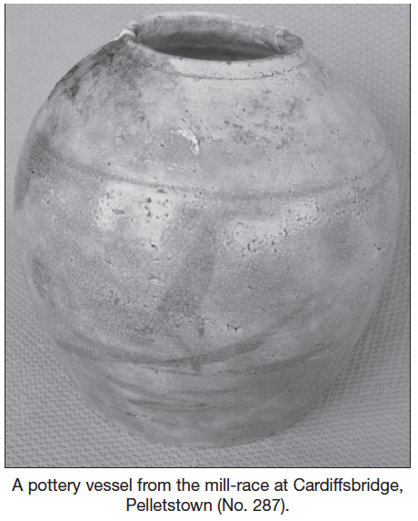
An almost complete glazed earthenware vase was recovered from the upper silt deposit. The vase measures c. 35m in height and was glazed both internally and externally. The fabric of the pot consisted of a fine creamy-orange/beige baked clay. The glaze was pink and was applied over blue decorative banding and abstract motifs. The glazed earthenware pot is from the Fujian province in China and dates from the Qing dynasty, c. ad 1850–1900 (Jessica Harrison-Hall, pers. comm.). These pots were commonly used as food storage jars, although this discovery in Finglas is both contextually and functionally intriguing.
Cardiffsbridge Castle and outbuildings
The testing was plotted to examine the ‘site of’ castle as marked on the OS maps. A fragment of the castle appears to be illustrated on the first-edition map; this building, when measured off the original map, measures c. 5m x 4m (clearly too small for a tower-house or castle) and would appear to represent the corner of the castle, which survived as a solitary standing fragment in 1837. The castle appears to have completely collapsed by the end of the 19th century and is illustrated as ‘site of’ on subsequent editions of the OS.
Two robbed-out foundation trenches, representing the probable west and east sides of the structure, were discovered on the site of castle. The trenches consisted of large amounts of mortar and small angular stones. A possible internal castle wall was also uncovered.
Other possible associated features were discovered adjacent to the castle site. A ditch extended from the castle and was orientated north–south. The ditch could be seen on the surface as a very low bank. The feature measured about 3m wide and was approximately 1.2m deep. This feature was also identified during the geophysical survey and appears to form part of a rectangular enclosure measuring 14.5m north–south by 10m. The ditches may represent the robbed-out walls of the castle itself.
Another ditch was discovered which extended across the trench in a north–south direction. This is also present within the geophysical survey and forms part of the rectangular enclosure. The ditch was filled by a dark-grey/brown silty clay with inclusions of animal bone, red brick, mortar and stone.
A deposit of limestone, pantile, mortar, sand and gravel was located 40–50m to the south of the castle site. A single wall was identified within the deposit. The wall survived to a height of 0.6m and was 0.4m wide. It was built from cut limestone blocks up to 0.3–0.5m in diameter. Linear banding was present in the deposits of rubble to the east of the wall. The deposits sloped upwards to a small glacial mound of gravel and ended at that feature. The deposit of building rubble identified in the trench was located in a circular area. Two sherds of post-medieval pottery were retrieved from the trench. These consisted of glazed earthenwares of 17th- or 18th-century date.
Cardiff’s Castle is recorded at this site in the 17th-century Civil Survey, accompanied by cottage and an orchard. Rocque’s map of 1760 also shows two buildings at this approximate location. It is likely that the castle was a later medieval tower-house, which may have been 15th or 16th century in date. It is possible that the limestone deposit is the remains of a building associated with the castle site. Rocque’s map of 1760 shows two buildings and an enclosed garden or orchard at this location.
Mill buildings
A series of low stone walls were located at the eastern end of the mill-race channel in Area 4 in undergrowth. Four significant walls were identified and varied in width from 0.4–0.75m. This structure represents the remains of mill buildings associated with the mill-race channel described above. The mill buildings are contemporary with the mill-race channel, which certainly pre-dates 1837, as they are illustrated on the first-edition OS maps. The mill complex is very likely to be contemporary with the occupation of Cardiffsbridge Castle, some time between AD 1500–1700.