2010:181 - RUTLAND ISLAND WRECK 2 (Agnes’ Bight), Burtonport Harbour, Donegal
County: Donegal
Site name: RUTLAND ISLAND WRECK 2 (Agnes’ Bight), Burtonport Harbour
Sites and Monuments Record No.: N/A
Licence number: 10E0442
Author: Connie Kelleher, Underwater Archaeology Unit
Author/Organisation Address: National Monuments Service, Department of Arts, Heritage & Gaeltacht Affairs, Windmill Lane, Reen Point, Blennerville, Tralee, Co. Kerry
Site type: Wreck
Period/Dating: Late Medieval (AD 1100-AD 1599)
ITM: E 560808m, N 922949m
Latitude, Longitude (decimal degrees): 55.052500, -8.613333
In November 2009, local diver Liam Miller contacted the Underwater Archaeology Unit (UAU) to report the discovery of a second wreck in Rutland Harbour. Previously, in 2008, Mr Miller had reported the discovery of a wreck in the harbour, the Correns Rock Wreck (Rutland Island Wreck 1, see No. 180, Excavations 2010). Rutland Island Wreck 2 is located some 75m north-east of the Correns Rock Wreck site. The newly discovered wreck is smaller and in shallower water, lying between 3m and 5m at high water. The new wreck is relatively intact, from bow to stern, with a large portion of its starboard side remaining, including turn of the port side; it is a heavily constructed wooden wreck, measuring c. 20m in length and lying at a depth of 3–5m of water at high tide.
The wreck site is located approximately 100m off the south-east shore of Rutland Island and just to the south of the channel into the main pier at Burtonport. The local name for the area is Agnes’ Bight, referring to a shallow navigation channel allowing access for smaller vessels that is situated to the south-west between the Correns Rocks and Rutland Island proper. The wreck site lies in an area of the bay that is not generally subject to heavy tidal movements except during periods of the strongest spring tides at specified periods during the year. The wreck lies within a sandy seabed at a gradient that ranges from its stern positioned to the north-west, at c. 3m at high water, sloping to its bow section lying at 5m at high water—a difference of c. 3m from stern to bow.
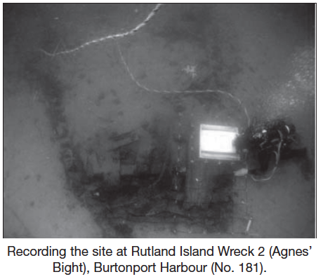
In 2010 a detailed survey and pre-excavation plan of the wreck was carried out, comprising metal-detection survey, outline plan survey and detailed recording of exposed features. An area of c. 20m in length of wreck is visible on the seabed, orientated north-east/south-west and c. 0.6m across the beam. On completion of the preliminary plan, two small trenches were opened, measuring 2m x 1m, at either end of the wreck to confirm the stern and the bow ends.
A hand-held suction dredge (air lift) was employed to open Test-trench 1 (T1), the bow. The area mapped out measured 2m x 1m across. This part of the wreck is the deepest – c. 5m at high tide, lying on a gentle slope orientated south-west. A small area was opened to confirm the bow area and to assess the nature and extent of the wreck in this location. A 0.15–0.2m covering of sand with a high concentration of shell covers the entire wreck and is the dominant feature of the seabed morphology in the area. This was removed easily and it overlay a layer of compacted silt, almost estuarine in nature. This greyish, anaerobic material has essentially sealed the wreck, ensuring good preservation and stability across the site. A sample of this context/layer (C2) was taken for analysis.
Almost immediately, artefactual material was encountered. Visible on the surface of the wreck (within C1 – the sand and shell mix surface of the seabed) were red fire bricks, identified from the outset as galley bricks. The galley would have been located towards the bow of the ship in this general area and it was obvious that it had collapsed and been spread across the site over time. As the excavation progressed in T1, more galley bricks were revealed across the entire bow area, confirming the collapse of the galley in this location. Smaller artefacts began to show up, contained within C2—the compact dark-greyish deposit that appears to seal the wreck site. Small, broken sherds of pottery were contained within this and were recovered. A wet sieve was set up on the bottom to ensure that all material excavated, including that expelled through the back of the air lift, was caught and gone through as part of the finds retrieval strategy.
Once it was positively confirmed that this was the bow area and the trench was cleaned sufficiently to allow detailed recording, and considering that small and important artefactual material was being encountered at a shallow level, it was decided to cease excavation at this point in order not to cause any more disturbance to the site than was absolutely necessary.
Test-trench 2 (T2), measuring 2m x 1m, was opened at the stern end of the wreck to confirm its position and to assess its nature and extent. Stratigraphy here was similar to the bow end of the wreck and, again, smaller finds in the form of pottery sherds and a button from a uniform were recovered from C2.
The stratigraphy is deeper in this area than at the bow end, and the excavation revealed that a large portion of the stern end, including internal transom timbers, flooring timbers and ceiling timbers at first deck level, are extant, and that externally the rudder mechanism, including the sternpost and areas that received the gudgeons, are in situ. Remains of the rudder itself might lie buried deeper or might lie outside the wreck, having broken off and collapsed over time. The depth of hold was significant, with almost 1m of material being removed from inside the transom area comprising a mixture of C1 (seabed material) and C2 (compact dark-grey clayey silt), which reached down on to the lower stern timbers. Revealed in this area, lodged beneath the transom knees, was the top or bottom of a wooden barrel or bucket, which was recorded in situ and then recovered.
Once a sufficient area had been uncovered to ensure proper recording and analysis, excavation ceased, the trench was backfilled and sandbags used to cover and stabilise the area.
Within both trenches and as is evident across the wreck site, contained within C2, are twigs and sharpened stakes. It is not clear what these are, as more extensive excavation is needed to clarify this, but they are most certainly cultural in nature. They appear to stretch the full length of the wreck internally and may be either something to do with wattle defensive structures carried on board the ship to be used on land for protective barriers by archers or may represent something that has washed on to the wreck over time. A sample was taken for analysis.
From the limited excavation undertaken at the wreck site in 2010, 56 artefacts have been recovered. Internally, within the wreck itself, select features primarily ends of timbers exposed on the seabed and ends of rope emerging from the sand, indicate the potential for this site to retain significant archaeology. Midpoint within the wreck, and slightly exposed on the surface, an artefact originally thought to have been a hoop from a barrel was visible, and it was decided to recover it to ensure its preservation. During the course of its excavation, however, it became obvious that it was not a barrel hoop but in fact the remains of a longbow. Although in sections, the overall length of the bow when recovered and reassembled was 2.05m. This is currently undergoing analysis and detailed recording.
Several different types of pottery sherd were recovered from the two test-trenches, all coming from within C2 or deeper. These vary from Merida-type ware to a fragment of an internally lead-glazed olive jar. A fragment of Chinese porcelain was also recovered and, in all, ten sherds of broken pottery were recovered during the test excavations of the two small trenches. The assemblage would give a broad mid-to-late 16th-century date for the site (preliminary observations by Rosanne Meenan).
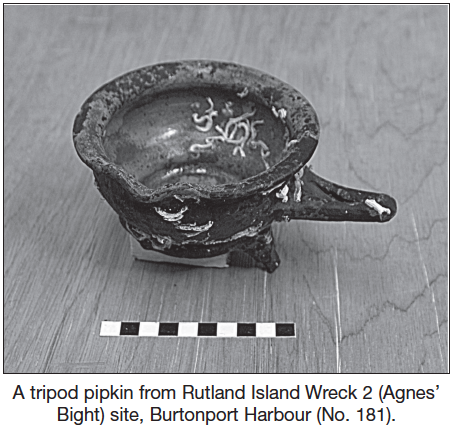
One of the local divers, during the course of a survey of the harbour, also recovered a complete pottery vessel known as a tripod pipkin. This was lying some 12m to the south-west of the wreck site, where some debris from it appears to have spread downslope. Again, a general 16th- to early 17th-century date for the artefact is applicable.
Two lead scuppers, on either side of the bow, were recorded and recovered as evidence for the drainage system of the ship and its obvious collapse over time. They were located on either side of the bow, having fallen on to the seabed from the upper works of the ship. A detailed metal-detection survey was carried out across the site, resulting in the recovery of several pieces of lead, including musket shot, small ingots, a fragment of tin and a cannon ball from within the wreck.
A number of other finds were also noted and recorded during the course of the dive project. To the south-west, c. 12m from the main wreck site, a broken iron kedge anchor, concreted to the reef there, was recorded. This is a small anchor and would have been suitable for a ship the size of Rutland Island Wreck 2. However, the angle of the anchor in the reef suggests rather that it may be associated with the Correns Rock Wreck. The anchor was recorded in detail. In the general area a long worked timber, very degraded and water-rolled, was recovered but left on the Rutland Wreck 2 site. It has a series of carved recesses along its length to take possible duck boarding or something similar. Its full length measures almost 4m but its original length may have been longer again. The wood is not oak but a softwood, so it did not form part of the primary construction timbers for the vessel. Its proximity to the anchor indicates that it may be associated with the Correns Rock Wreck and its mobility means that it may also have floated into the area from another source altogether.
The remains of Rutland Island Wreck 2 (Agnes’ Bight), as it is currently known, consist of part of the very lower levels of the port side, the keel and keelson and a large part of the starboard side of the vessel. The wreck is present from bow to stern, so we can deduce the length of the ship at its lowest hull level. It will, if the starboard side can be exposed, be possible to re-create and deduce the lines of the ship from the angle of the existing timbers and essentially the full lines of the vessel can be reconstructed. The construction is of heavy oak timbers, secured in place by use of a combination of iron and wooden fixtures and fittings, typical of the period. A substantial part of the stern assemblage is present, including the lower transom timbers, transom knees, first futtocks, external sternpost and possible lower levels of the rudder itself. Also present in this area are two ceiling timbers from part of the lower deck, with supporting knees underneath. The keel appears to be broken, indicating that the ship broke its back upon wrecking.
Initial observations on the bow section, where it is broken and its contents spilled out, suggests that the ship was wrecked bow first. More extensive excavation is required, however, to explain the whole wrecking process.
The Underwater Archaeology Unit is returning to the wreck site in 2011 to excavate one half of the site, and research on the type of vessel and its possible identity is ongoing.