2010:180 - CORRENS ROCK WRECK (Rutland Island Wreck 1), Burtonport Harbour, Donegal
County: Donegal
Site name: CORRENS ROCK WRECK (Rutland Island Wreck 1), Burtonport Harbour
Sites and Monuments Record No.: N/A
Licence number: 10E0314
Author: Connie Kelleher, Underwater Archaeology Unit
Author/Organisation Address: National Monuments Service, Department of Arts, Heritage and Gaeltacht Affairs, Windmill Lane, Reen Point, Blennerville, Tralee, Co. Kerry
Site type: Wreck
Period/Dating: Modern (AD 1750-AD 2000)
ITM: E 571766m, N 915214m
Latitude, Longitude (decimal degrees): 54.983744, -8.441084
In the summer of 2010 the Underwater Archaeology Unit (UAU) of the Department of Environment, Heritage and Local Government carried out a detailed underwater survey and targeted excavation of a shipwreck located off Rutland Island, Co. Donegal. A local diver, Mr Liam Miller of Inishfree Charters and Dive Centre, Burtonport, discovered the shipwreck in 2007 and immediately reported it to the UAU. From 2008–2009 the UAU undertook survey and detailed recording at the wreck site. The site is generically referred to as Correns Rock Wreck, making reference to the rocks and reef system upon which the wreck lies, but has a subtitle of Rutland Island Wreck 1, to distinguish it from another previously unknown wreck located nearby, discovered in 2009. This second wreck is preliminarily called Rutland Island Wreck 2 (Agnes’ Bight), pending positive identification, and was also the subject of work by the UAU in 2010 (see No. 181, Excavations 2010).
Mr Miller and his diving colleagues also identified two iron cannon at a distance from the Correns Rock wreck site, which may be associated with it. From initial observations, the guns appear to be of 18th-century date, though it has to be acknowledged that, without specific identifying marks, iron cannon are notoriously difficult to date.
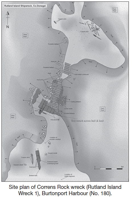
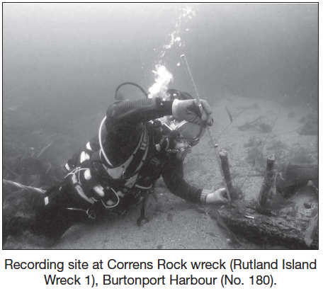
From 2008 to 2010 the UAU carried out a number of inspection dives, detailed surveys and targeted excavation on the wreck site to identify its nature, extent, date and possible identity. The wreck lies at an average depth of 8m at high water and an area measuring 20–25m of surviving hull was mapped, with the wreck remains comprising wooden structural timbers with primarily cupreous fastenings, of copper, copper alloy or brass, along with wooden tree nails and small iron nails. To the north-east of the main expanse of hull, several dozen fastenings were identified, including keel pins, bolts, nails and tacks, evidence that the site was subject to extensive erosion over time as much of the loose timbers and cupreous material is well abraded and water-rolled. The variety in length of copper pins was striking, varying from c. 0.3m to over 1.7m. A selection of the fastenings were recovered for analysis, including a large keel pin, which measures some 1.73m in length, indicating that the ship was a heavily built vessel. Preliminary analysis of the wood fragment along its shank has identified it as oak (Aoife Daly, pers. comm.).
The main in situ section of the lower hull is wedged between the western and eastern reef of the Correns Rock, which has preserved the remains from being totally destroyed. To the south-west of the main wreck section, a further scatter of material was recorded, including more cupreous bolts and pins and concentrations of copper-alloy nails and tacks lying within the cracks and fissures of the surrounding reef. Also located in this area is a large section of disarticulated keel partially buried in the seabed. A detailed plan of the hull and outlying wreck remains was successfully carried out by the UAU and all outlying and ex situ wreck material mapped.
The hull structure
The structural timbers of the very lower part of the hull of the ship comprise the keel, attached external planking, internal floor and first futtocks, and five ceiling timbers at the lowest part of the inside of the hull, though not running up to the keel rabbet. The hull timbers run under the reef on both sides of the keel, with the eastern side of the hull being more exposed. The exposure on the eastern side ranges from 1.5m–2.5m in places, compared with its western counterpart that is exposed only marginally, immediately west of the visible section of keel; the remainder of the hull is fully covered by the reef on that side. No details have been identified, to date, to indicate which is the starboard or port sides of the wreck. The futtocks that are visible were noted as having scarf joints, with one having a butt joint. At the southernmost extremity of the hull, on the western side of the keel, the framing timbers appear to be missing but more may lie buried beneath the reef along that side of the hull. The external planking noted at the southern end of the main structure, running beneath the framing timbers, is exposed on both sides of the keel. The exposed edges are heavily eroded, with no visible sign of sheathing having been attached to the external face of the planking. One plank was recovered for analysis.
In 2010 an area across the exposed keel and hull was excavated to allow detailed recording to take place and investigation under the hull to see if there was any sheathing evident. A flat, vertical scarf was recorded in the keel at that point and a pair of cupreous pins driven horizontally across the scarf before and abaft of the scarf joint. Three large keel pins extend vertically, two on the southern side and one to the north of the exposed scarf joint; these would have fastened the keel to the keelson. The keelson timber is missing and the keel itself is extremely eroded, resulting in some of the horizontal fixing bolts being exposed and dislodged. The degree to which the large keel pins are exposed, some nearly 1m in height, suggests that, not only was the keelson a large structural element but a large part of the keel itself has been lost, being worn away over time. A small section of hull, measuring 0.5m by 1m, next to the keel section, was revealed, constructional detail noted and the relationship of each element to each other ascertained. The underlying external planking was exposed where flooring timbers are missing and the garboard strake identified. The quality of the floor timbers at this point is good, showing little if any signs of abrasion, with the garboard strake still sitting firmly into the rabbet of the keel. Limber holes and limber channels were also revealed, cut into the underside of the floor timbers. These run along the keel on both sides and measure 50mm square, with the channels clearly visible running beneath the exposed floor timbers at that point. The recovered timber sample, part of the external planking, was located immediately to the west of the excavated area. No evidence of any sheathing beneath the hull section excavated was noted.
The section of disarticulated keel to the south of the main part of the wreck site was only partially buried and, when investigated, came loose quickly. Keel pins, up to 1.4m high, and two through-bolts penetrate the eroded fragment of keel, with each one of these showing individual signs of attrition. They provide evidence for the now missing keelson, which would originally have been fixed atop and the false keel that would have been fixed to the underside of the keel when intact. Three tree nails were also recorded along the length of the broken keel. Although the disarticulated keel piece is extremely abraded and shows signs of possible burning along its length, it contains some interesting constructional information. The garboard rabbet is evident on one side, along with a loose, very eroded fragment of a possible garboard strake. From one area of the rabbet, a single piece of lead string was recovered. An in situ fragment of lead strap was tacked on to the seam of the rabbet and next to it, where the lead would have continued but is now gone, was a very fine sample of oakum caulking. Nearby, a small copper tack was visible protruding from the edge of the rabbet. The locating of all these materials together suggests that they were used to ensure that the hull remained watertight.
A general search of the reef to the immediate west of the hull structure identified the continuation of keel pins, exposed in a line within the reef, confirming that the keel and hull structure continues in this area but is buried beneath the overburden of collapsed reef.
The iron guns
The two iron guns were also recorded by the UAU. They are located approximately 70m south-west of the Correns Rock wreck site and at a deeper depth of 13m, located at the bottom of a vertical reef. They lie in a line, being indicative of either having rolled off the reef and been lost from the hold of the ship if it tore out its hull bottom on the rock or that they may have been deliberately jettisoned to lighten the ship if grounded on top of the reef. Both guns measure approximately 2.3m in length (taking into account the heavy concretion on both cannon) and, from the shape of the cascables, buttons and the trunnions, they appear to be 18th-century in date. One gun lies on its side, while the second is heavily concreted to the adjacent reef, which makes distinguishing any identifiable marks difficult. The distance of these guns from the main wreck site means that they cannot automatically be associated with the known wreck, as they could also represent isolated artefacts or indicate the presence of another wreck close by yet to be discovered.
A number of artefacts were recovered from the wreck site during the course of the UAU’s work. These include a neck fragment from a green-glass wine bottle. It has a lip and applied string rim and slight turn of the shoulder and preliminary analysis suggests it is an 18th-century wine or rum bottle. Part of a small, circular pulley block was also found to the south-west of the main hull structure, near the disarticulated keel timber. The pulley piece measures 130mm in diameter, with one side being slightly concave. It has a flat outer edge and the reverse side has a triangular recess with three perforations, to accommodate a pivot mechanism. A sherd of decorated pottery was also recovered from the wreck site, with a preliminary date of the 18th century being attributable to it.
Discussion
The evidence to date from the Correns Rock Wreck is pointing to a mid-18th- or early 19th-century vessel. The preponderance of copper, copper alloy or brass used in the fastenings below the waterline, though experimented with over a long period, began to be used extensively from the mid-18th century, with evidence from other wreck sites, such as the Mica wreck, discovered in deep water in the Gulf of Mexico in 2001, providing comparative information (Jones 2004, 75). The hull construction too has close parallels to other wrecks of that period (Wilde-Ramsing et al. 1992, 1–77). The fragment of the wooden pulley is closely similar to that recovered from the early 19th-century French wreck of the Mercure (Beltrame and Gaddi 2002, 68).
Twelve wrecks are recorded for the general area around Burtonport and research is ongoing as to the potential for a number of these to be the Correns Rock Wreck (Shipwreck Inventory of Ireland Data: Donegal). These include one of two French frigates recorded as having been lost off Rutland following an encounter between the English and French fleets during the 1798 Irish Rebellion. The Traveller, wrecked in 1819 en route from Liverpool to Killala in Mayo, may be another, as may that of either the Alex Maxwell or the Samuel, both lost in the year 1821; the latter, a vessel of Beaumaris carrying a cargo of slates from Bangor in Wales to Galway, was wrecked when it hit a rock near Rutland. Nothing more is known of the Traveller or the Alex Maxwell, so it is not possible at present to speculate as to what types of ships they may have been, but, dating from the early part of the 19th century, they may well have incorporated cupreous fastenings in their constructional design. It is also a possibility that the Correns Rock Wreck is a previously unrecorded ship, lost with no living memory of its wrecking.
Research is ongoing and it is hoped to return to the wreck site to carry out further survey and investigation in the near future.
References
Beltrame, C. and Gaddi, D. 2002 Report on the first research campaign on the Napoleonic brick, Mercure, wrecked off Lignano, Udine, Italy in 1812. International Journal of Nautical Archaeology 31(1). Oxford.
Jones, Toby N. 2004 The Mica shipwreck: deepwater nautical archaeology in the Gulf of Mexico. Unpublished Masters Thesis, Texas A & M University. (This wreck is thought to date between 1775 and 1830 and more specifically to between 1800 and 1830. The use of such an amount of copper or copper alloy suggests a well-built and well-maintained vessel, p. 75.)
Shipwreck Inventory of Ireland Data – wrecks of County Donegal. Department of Arts, Heritage and Gaeltacht Affairs (accessible by appointment with the Archive Unit in the Department in Dublin).
Wilde-Ramsing, M., Angley, W., Lawrence, R.W. and Scofield, G.J. 1992 The Rose Hill wreck: historical and archaeological investigations of an eighteenth-century vessel at the colonial river landing near Wilmington, North Carolina. North Carolina Department of Cultural Resources, pp. 1–77.