2010:088 - CAHERMACNAGHTEN, Clare
County: Clare
Site name: CAHERMACNAGHTEN
Sites and Monuments Record No.: N/A
Licence number: 10E0146
Author: Richard Clutterbuck and Elizabeth FitzPatrick, School of Geography and Archaeology, NUI Galway
Author/Organisation Address: 31 Birchfield Park, Goatstown, Dublin 14
Site type: Building
Period/Dating: Post Medieval (AD 1600-AD 1750)
ITM: E 518884m, N 699749m
Latitude, Longitude (decimal degrees): 53.042250, -9.209632
A third season of excavation, grant-aided by the Royal Irish Academy, was conducted in the Cabhail Tighe Breac settlement associated with the O’Davoren Brehon Law school at Cahermacnaghten, Burren, Co. Clare. The settlement consists of four rectangular buildings and a clochán, pipe kiln, several small enclosures and enclosed fields. The principal aim of the three seasons of excavation was to establish whether the largest of the buildings, locally named Cabhail Tighe Breac, was the late medieval sgoilteagh or schoolhouse of the O’Davorens, and to determine the role and chronology of some of the other buildings in the settlement. The second season in 2008 (Excavations 2008, No. 112, 08E435) revealed that Cabhail Tighe Breac appears to have been initially constructed as a schoolhouse in which the business of learning and compiling manuscripts probably took place, but the building also had an afterlife as a domestic residence in the post-medieval period.
The first season (Excavations 2007, No. 150, 07E0395) investigated a building immediately north-east of Cabhail Tighe Breac and established that light industrial or craft activity, possibly the preparation of hides, had taken place there during the late 15th to 17th century, involving the use of lithic tools, among them shale axe-heads, chert and shale flakes, scrapers and possible borers. The tools, potentially spanning more than a millennium, had already been recycled, broken and abraided prior to their deposition and they represent ‘collected’ implements rather than an in situ culturally cohesive concentration of lithics from a single tradition.
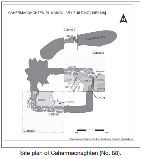
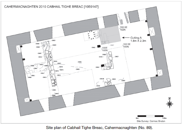
The focus of the excavations was a small building positioned immediately north-west of Cabhail Tighe Breac and a cutting opened in Cabhail Tighe Breac during the 2008 season which was completed (see No. 89, Excavations 2010, 10E0147). The excavations took place from 16 June to 16 July as a training exercise for archaeology students of NUI, Galway.
Prior to excavation, the small building appeared as a subrectangular grass-covered structure, c. 6.8m by 5.3m and orientated east–west, with some exposed stone showing through the grass cover. The walls of the building were 0.7m to 0.76m thick, except the north-west corner where the remains expanded to an irregular area, 2.6m east–west by 2.9m. Two potential entrance features were identified before excavation – a break at the south-west end of the west wall, 0.8m wide, and another c. 0.88m wide at the north-east corner of the east wall. A matching pair of cut, punch-dressed and chamfered arch-stones from a late medieval doorway was discovered 2.5m south-west of the building.
The excavation site was divided into three cuttings. Cuttings A and B (4.5m by 4.5m) were positioned in the south-west and north-east quadrants of the building respectively. Cutting C (1.5m east–west by 2m) extended north of Cutting B across an adjacent relict field boundary. The cuttings were positioned to allow an east–west and north–south section to be drawn through the excavation site. Archaeological stratigraphy on-site ranged in depth from as little as 0.12m in the centre of the building to c. 0.47m where the west short wall was exposed. The deepest stratigraphy was found next to the walls where demolition rubble and soil had accumulated. The shallowest areas of stratigraphy, towards the centre of the building, consisted of sod and topsoil overlying the natural karst bedrock.
A significant number of finds and animal bone from the topsoil were recovered to the immediate south of the building (34% of all finds and 44% of the total weight of animal bone), which suggests that this may have been an area of deposition for waste, or possibly a garden area. A layer of rubble was found covering the immediate interior and exterior of the building between the sod layer and the topsoil.
The building itself was a stone construction, 6.93m east–west by 4.71m externally, the interior of which was 3.46m by 5.66m with walls between 0.62m (east wall) and 0.79m (south wall) wide and between 0.18m (west wall) to 0.67m (south wall exterior face) in height. The east and west short walls were constructed of flat-bedded limestone slabs roughly hewn, surviving between one and three courses high, whilst the north and south long walls were made of a single course of large, flat blocks of unworked limestone derived from karst, set upright as inner and outer faces, with narrow rubble stone cores. Although a small fragment of mortar was recovered, it appears that the walls were clay-bonded. The exposed external corners of the structure were rounded and composed of flat-bedded roughly hewn limestone slabs. Apart from the entrance, the building contained no cut or finely dressed stone. The walls of the building were constructed either on old ground surface, on roughly packed limestone or on stony clay deposits used as bedding for the east short wall. Old ground soil also appears to have been left in place as an even interior surface, whilst a secondary occupation phase deposit, rich in animal bone, was found in the interior around the door. Limestone pavement or karst with frequent narrow grykes underlies the whole of the excavation area.
The entrance to the building (0.92m wide) was located at the north end of the east gable and survived as a fractured threshold stone and a pivot stone positioned on the south side of the doorway. Both the threshold stone and the pivot stone were cut and punch-dressed and appear to have been reused most likely from Cabhail Tighe Breac. The doorframe of the small building was probably constructed of wood, as the clay-bonded walls could not have supported the pair of arch-stones discovered to the west of the building. Considering the off-centre position of the doorway in the east gable and the structural problems this would have caused to a gable-ended building, the short east and west walls of the structure were likely to have been hipped, which would have placed less weight over the wooden door frame. The arch-stones appear to have been salvaged from Cabhail Tighe Breac at a much later date and not used. Nothing remains of the roof of the building or roofing material, although it can be assumed that it was thatched. Flat stones were used to produce a path or surface outside the entrance.
The relict field boundary excavated in Cutting C ran in a west-south-west to east-north-east direction at an angle to the building and appears to have been part of an enclosure contemporary with the building. It consisted of a low (0.32m) mound of collapsed limestone slabs and soil over a single course of undressed limestone.
A total of 183 finds were recovered during the excavation. These include 104 stone objects, 58 metal finds consisting of knives, nails, hooks, parts of two Jew’s harps and two copper coins—one of which appears to be a Kilkenny halfpenny from c. 1642–3—twelve clay-pipe fragments, five fragments of pottery and other possible ceramic material, and two bullets, a glass bead and a spindle whorl.
A radiocarbon age range of 1631–1688 (UBA–15892) was obtained from animal bone recovered from a primary deposit in the interior of the building and a secondary period of use was confirmed by a radiocarbon age range of 1734–1806 (UBA–15893).
An analysis of the plant remains identified primarily cereal grains, mostly oat with smaller quantities of wheat and barley. Charred and uncharred oat dominated the samples and could have derived from the use of oat straw as floor covering.
A preliminary interpretation of the excavation has identified three main phases of activity on this site. These include the construction and primary occupation of a small undifferentiated building in the mid-17th century (Phase 1); secondary use appearing to date to the later 18th century (Phase 2); and abandonment and demolition in the 19th and 20th centuries (Phase 3).
Excavations at Cabhail Tighe Breac from 2007 to 2010 have established that the buildings in the settlement are not all contemporary. Cabhail Tighe Breac appears to have been built first, probably as the O’Davoren schoolhouse, c. 1500, but it underwent modifications in the post-medieval period, during which it was used as a residence. The buildings excavated in 2007 and 2010 reused stone fittings from Cabhail Tighe Breac and appear to have been constructed in the mid-17th century after Cabhail Tighe Breac was refurbished as a dwelling.