2010:001 - ANTRIM TOWN, Antrim
County: Antrim
Site name: ANTRIM TOWN
Sites and Monuments Record No.: ANT050–181–183
Licence number: AE/09/22, AE/09/148
Author: Declan P. Hurl, Amey Consulting Ltd.
Author/Organisation Address: Rushmere House, 46 Cadogan Park, Belfast, BT9 6HH
Site type: Historic town
Period/Dating: Multi-period
ITM: E 715060m, N 886525m
Latitude, Longitude (decimal degrees): 54.713634, -6.214283
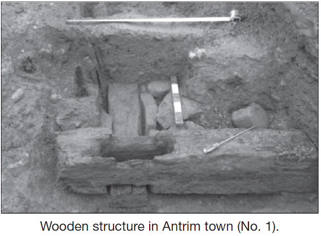
Works for the deep manhole pit in Antrim Castle Gardens, on the north side of Six Mile Water, revealed a wooden structure set in a series of three interlinked trenches. The structure consisted of two parallel beams, measuring 0.2–0.25m wide and 0.13–0.16m thick, running north-west/south-east approximately 4m apart. Connecting them along the south-east side was a further beam, 0.26m by 0.26m; carpentry joints on all three beams ensured a good connection. A slot was cut through the upper beam over each joint, in each of which the remains of upright planks were discovered. A series of wooden uprights flanked the south-west beam, though their association with the structure is uncertain. Radiocarbon analysis dated elements of the structure to the 7th or 8th century, though dendrochronological study of the upper beam suggested a felling date of around 1650. Subsequently samples of wood from timbers and objects associated with the beams were submitted for radiocarbon analysis, but petrochemical contamination of the wood appeared to have compromised the results and no direct artefactual evidence was recovered.
Also revealed in the area were two drystone drains, one substantial and the other considerably smaller, both probably dating from the 17th or 18th century.
The pipeline running east from the manhole in Antrim Castle Gardens across the route of the Dublin Road and the wall of the Antrim bastion was inserted by directional drilling. Three pits were opened in Market Square to install manholes to receive the pipeline and to direct it across Market Square to High Street. Further drystone drains, also probably dating to the 17th or 18th century, were uncovered in pits at either end of Market Square. The pipeline trench along High Street and a branch line along Railway Street were monitored; nothing of archaeological significance was identified.
At the request of Antrim Borough Council, clearance of the trench along the line of the collapsed 45m-long Antrim bastion wall was undertaken in preparation for the re-erection of the wall, for which a stabilising piling regime was proposed. Monitoring of the works revealed features associated with at least two phases of the bastion wall; the earlier one, 1m wide, was surmounted by the later one, 0.65m wide. An area of intense burning, 2.4m wide, was located in the centre of the wall span, which may have been associated with finds of slag and part of a furnace bottom located in the base of the later phase wall. Two copper-based trader’s tokens were found within the burnt material.
Two masonry features were uncovered in the east and south areas of the span. One was a small stretch of mortared rough stones, 1.5m long, 10m from the bastion and located on the east side of the wall; as it was not threatened by the work to re-erect the wall, it was not further investigated.
Approximately 6m from the south end of the wall, a 2m-wide feature cut into the slope of the terracebehind the wall. It was filled with stones, some being mortared to form a rough face to the south-east, and appeared to pre-date the later phase wall. It was partly excavated to permit the positioning of a pile to strengthen the proposed new wall.
Neither of the two masonry features appeared to relate to the three ‘pinning walls’, which had run from the bastion wall into the rampart for stability but which had not extended to the base of the bastion wall where the masonry features were located.
Also revealed was a possible ditch running approximately north–south beneath and at a slight angle to the line of the wall; this may be associated with sections of late medieval ditch encountered in previous investigations.
Editor’s note: Although excavated in 2009, the report on this site arrived too late for inclusion in the bulletin of that year.

