2009:644 - DULEEK: Abbeylands, Meath
County: Meath
Site name: DULEEK: Abbeylands
Sites and Monuments Record No.: ME027–038
Licence number: 08E0825
Author: Matthew Seaver, for Cultural Resource Development Services
Author/Organisation Address: Unit 4a, Dundrum Business Park, Dublin 22
Site type: Historic town
Period/Dating: Multi-period
ITM: E 703933m, N 766998m
Latitude, Longitude (decimal degrees): 53.642438, -6.428154
Excavations in advance of a pipe corridor took place in Abbeylands, a townland immediately south of Duleek bordered by the River Nanny and its wide floodplain. Duleek was an important settlement from early to late medieval period periods. The development corridor is located in close proximity to a number of sites, including the town of Duleek (ME027–038), the early medieval enclosure of Duleek (ME027–038019) and the Grange of St Michael (ME027–038:014–16, 11–12). This work followed test-trenching by Richard Clutterbuck (Excavations 2008, No. 952, 07E0927).
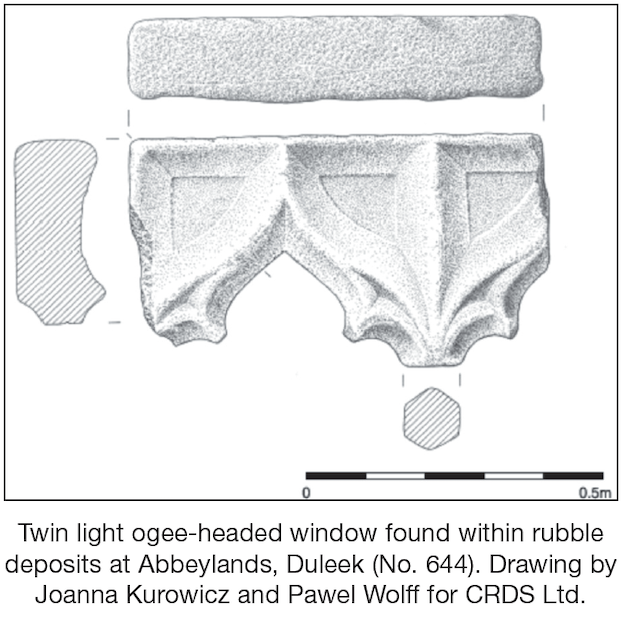
A 53m east–west trench, 1.2m in width, was dug from the County Council yard to the south of the Garda station in Duleek to the gate into the Abbeylands housing estate. The County Council yard is within 100m of Duleek Cross, known as the Dowdall Cross, in Market Green, and 50m from the medieval grange of St Michael. A number of 19th-century walls associated with the RIC barracks were identified in the council yard. Excavations in the greenfield on the boundary between the field and the town revealed up to 3m-deep deposits of modern refuse and building rubble overlying a stone surface which could be identified as a laneway associated with the barracks. A large quantity of stone rubble was uncovered which included a medieval twin light ogee-headed window, indicating the demolition of an important medieval structure in the vicinity.
The trench continued along the existing road between Carey’s Lane in the west and continuing east through Abbeylands housing estate towards the Paramadda River. A series of archaeological features were identified, described here from west to east. A significant north-east/south-west boundary ditch, 2m wide by 0.92m in depth, was identified cutting through the lowest deposit of ploughsoil. It was filled with compact silty clay, overlain by dark-brown sandy silt, with the upper deposit consisting of orange/brown loose sandy clay. Both second and tertiary deposits contained occasional animal bone and medieval pottery. This ditch is likely to be a burgage boundary ditch from plots fronting on to Colgan’s Lane, where Kieran Campbell uncovered evidence for extensive 13th-to 15th-century activity that is likely to relate to street-fronting structures (Excavations 2002, No. 1449, 02E0844).
Some 18m further east a stone structure was identified within the pipe trench below the road in the centre of Abbeyland housing estate. The trench was widened to 3m for c. 7m (east–west). This revealed a circular stone structure with a south-facing entrance, of which 40% was exposed in the trench. The remainder of the building remained beyond the limits of excavation below the footpath and garden to the north. The internal diameter of the building was c. 3.4m, while the external diameter was c. 5.2m. The width of the extant wall was between 0.9m and 1m. The wall cut truncated an earlier medieval garden soil deposit. The interior of the structure was cut into natural boulder clay and consisted of four random courses of roughly hewn limestone blocks bonded with clay up to 0.8m in height. Only one course remained in situ on the external face of the wall. The entrance to the structure was splayed. It had an internal width of 0.9m and an external width of 1.2m. The interior of the building had a stone pebble floor/surface.
Two more walls were identified associated with this structure. One wall was located to the west of the entrance (0.7m by 0.42m by 0.2m) and one wall to the east (0.8m long by 0.46m wide by 0.1m high). Both walls were perpendicular to the main structure. Although these walls were not tied into the main structure, they were probably contemporary with each other. The building complex was interpreted as a possible dovecote. Two separate dovecotes are mentioned in medieval extents, one in part of the main grange complex and another which stood above the River Nanny. They are mentioned in 1579 and a thatched dovecote is mentioned in the early 17th century (Nicholls 1994, 1579; Hardiman 1826, Pat. 3, Jac. 1, 69).
On abandonment, the primary deposit was a brownish-grey clayey silt 0.03m in depth. The second deposit within the building was a deliberate deposit of demolished mortared stone and clay with frequent animal-bone inclusions measuring 0.98m in depth. This was sealed by a deposit of smaller stones and silty clay 0.15m deep.
A shallow concave north–south gully identified 2m to the east of the stone tower measured 1m wide by 0.32m deep (F27). To the west of the gully a small bank could be seen in the section face. It was filled by loose dark-grey clayey silt containing fourteen sherds of medieval pottery and three corroded iron nails.
A cut scarp or ditch with a north-east/south-west orientation was identified 0.75m to the west of gully (F27). A total length of 3.35m of this scarp was identified within the trench cut. The orientation of this feature is not comparable to any of the other features on the site. The fill of this feature was dark-grey, clayey silt with orange and beige clay inclusions. A small irregular-shaped pit, 1.5m by 0.5m by 0.25m in depth, was identified on the northern edge of the trench. This contained charred cereal grain and weeds of cultivation.
An irregular-shaped hollow was uncovered, 3.5m by 0.25m deep, at the eastern end of the trench. It was filled by dark-grey silt with frequent charcoal inclusions. Four sherds of medieval pottery and a small fragment of two-colour floor tile dating from the 13th century, and previously unknown from Duleek, were also recovered. All the features to the east of the tower were covered by a badly denuded metalled surface identified in the eastern part of the pipe trench excavated in Abbeylands. It measured at least the width of the trench and ran for 17m. It sealed the features mentioned above and was itself sealed by a ploughsoil/garden soil deposit.
Post-medieval features comprised a series of north-west to south-east furrows which were overlain by 1m of ploughsoil deposits and sealed by Carey’s Lane. A copper-alloy stick-pin was retrieved from within. The southern edge of the trench encountered the estate wall, which stood until the construction of the current housing estate and cut through the walls associated with the stone tower. Specialist work including radiocarbon dates should provide better indications of the chronology of the stone tower and associated features.
Reference
Hardiman, J. 1826 Inquisitionem cancelleriae hibernicum repertorum.
K. Nicholls, 1994 The Irish fiants of the Tudor sovereigns, Dublin.