2009:579 - MULLADRILLEN, Louth
County: Louth
Site name: MULLADRILLEN
Sites and Monuments Record No.: LH017–011
Licence number: 09E0510
Author: Kieran Campbell
Author/Organisation Address: 6 St Ultans, Laytown, Co. Meath
Site type: Souterrain
Period/Dating: Early Medieval (AD 400-AD 1099)
ITM: E 696386m, N 789809m
Latitude, Longitude (decimal degrees): 53.848799, -6.535148
Testing took place on 19 October 2009 in advance of the design of a housing development situated in the southern environs of Ardee town. The purpose of the testing was to determine if a souterrain, indicated on OS maps, was present on the site. The souterrain is not shown on the first-edition 6-inch map, surveyed in 1835, but is indicated as ‘Cave’ on the 1:2500 or 25inch map, surveyed in 1908, and as ‘souterrain’ on the 1938 6-inch map. The souterrain possibly shows as a cropmark on the 1995 OS black-and-white aerial photographic survey (www.osimaps.ie). The location is on the steep (c. 1 in 5) southern slope of a prominent east–west ridge. Previous testing in 2000 by Finola O’Carroll, in connection with a proposed access road at the base of the slope below the souterrain site, did not uncover any archaeological material (Excavations 2000, No. 699, 00E0361).
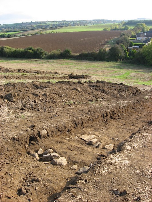
Five parallel trenches, each 36m long and orientated north–south, were centred on the location of the souterrain, as indicated on the OS 6-inch and 1:2500 maps and according to the national grid coordinates given in the RMP. An unroofed section of a souterrain passage was located within 3m of the marked location. The two side walls were aligned east–west at NGR 296456 289795. The capstones had previously been removed and the passage filled with compact silty clay and some stone. The internal width of the passage was 1.04m. A construction trench, not well defined on the south side, had a possible overall width of 2.25m. It was later established that the land at Mulladrillen was formerly part of the farm attached to St Brigid’s Hospital, Ardee, and it was during this period that the capstones were removed and the souterrain filled in, probably in the first half of the last century (John Rafferty, Ardee, pers. comm.).
Extensive archaeological deposits were uncovered within c. 15m of the souterrain, with outlying deposits 12m to the south-west and 20m to the east. The deposits of dark charcoal-flecked soil, containing ash and fragments of animal bone, clearly indicate domestic habitation. The deposits were continuous over half the 36m length of the two trenches nearest the souterrain. No enclosure was identified. The souterrain and associated material may relate to a settlement, a ringfort or open settlement, located on the summit of the hill. A buffer zone was established around the souterrain and the associated archaeological deposits and is to be excluded from all development and landscaping works.