2009:577 - GLYDEFARM, Louth
County: Louth
Site name: GLYDEFARM
Sites and Monuments Record No.: LH014–008
Licence number: 09E0114
Author: Kieran Campbell
Author/Organisation Address: 6 St Ultans, Laytown, Co. Meath
Site type: Enclosure
Period/Dating: Undetermined
ITM: E 696430m, N 797052m
Latitude, Longitude (decimal degrees): 53.913856, -6.532202
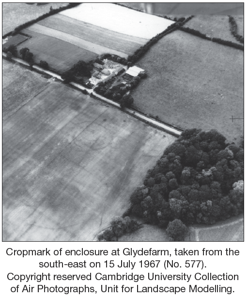
A site for a dwelling-house included part of an enclosure site identified from a cropmark on an aerial photograph (CUCAP, ASW 2). The photograph, taken from the south-east on 15 July 1967, shows an approximately circular enclosure defined by a ditch with a parallel inner ditch at the south-west circuit. The site is on a low east–west ridge at the north end of a large tillage field from which the ground slopes south into the valley of the River Glyde. No enclosure is indicated at this location on Taylor and Skinner’s 1778 map of Co. Louth or on the first-edition 6-inch map surveyed in 1835.
A plot of the cropmark superimposed on the site layout plan for the development (by Niall Lynch, CRDS Ltd) determined that approximately one-third of the enclosure lay within the garden area of the proposed development. Most of the enclosure is in the adjoining site to the east and is covered by a barn and storage area for plant and vehicles built c. 1972. The enclosure measures c. 55m east–west by 45m. Some straight lines overlapping the enclosure probably represent old field divisions.
Test-trenches were excavated on 24 March 2009 on the site for the house, driveway and percolation area. A buried ditch, Ditch 1, was exposed which would transect the north-east corner of the proposed house and the conservatory. The straight ditch, aligned north-west to south-east, was 2.2m wide at the north end, narrowing to 0.7m over a distance of 13m. During subsequent monitoring of the excavations for the foundations, a depth of 0.3m was recorded at the narrow south end; the foundations did not extend to the base of the ditch at the north end. The fill was silty clay with stones; no charcoal or other finds were noted other than some shells of garden snails. No other features were uncovered in the areas due to be disturbed.
A test-trench was excavated south from the percolation area for the purpose of locating the enclosure ditch. A 3m-wide ditch, Ditch 2, was exposed c. 6m from the percolation area. Aligned east-north-east/west-south-west, it corresponded to the position of the enclosure ditch plotted from the aerial photograph. The fill was moderately stony sandy silty clay with a 0.6m-wide stone-free band along the northern edge, interpreted as a primary silting layer. The ditch, located in the garden area, was not excavated and should not be further disturbed.