2009:561 - MULLAGH, Longford
County: Longford
Site name: MULLAGH
Sites and Monuments Record No.: N/A
Licence number: 09E0314
Author: Mandy Stephens, CRDS Ltd.
Author/Organisation Address: Greenanstown, Stamullan, Co. Meath
Site type: Burial ground and Kiln - corn-drying
Period/Dating: Multi-period
ITM: E 611498m, N 775477m
Latitude, Longitude (decimal degrees): 53.728831, -7.825750
Site 2, Mullagh, was located 1.95km west of Longford town. This was one of three sites identified in the townland along the route of the N5 Longford bypass. Areas of bog and marsh surround the low hill on which the site is located. The site consisted of a cemetery comprised of 56 individual burials concentrated in the north of the site, with the densest cluster located at the north-west. Burials were generally oriented east–west or north-east/south-west and were simple extended inhumations.
A total of 37 adults and sixteen juveniles were identified. Skeletal remains were poorly preserved; many were partial and fragmented on lifting. Osteological analysis was conducted on site prior to lifting and further analysis will be conducted during post-excavation work (ongoing). A number of the burials were intercut. Burials were truncated, lay within and were sealed by a layer of redeposited clay. These factors suggested the cemetery was used continuously for an extended period of time.
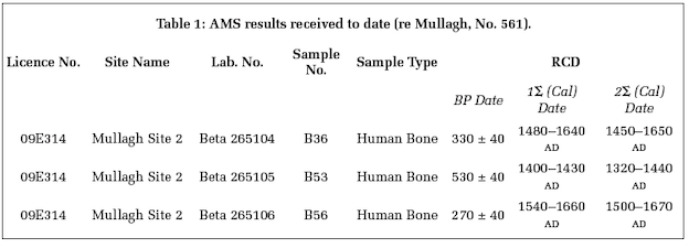
Burials identified in Stage 1 testing, directed by Graham Hull of TVAS Ltd (Excavations 2008, No. 803, 08E0861), were radiocarbon-dated to cal AD 1468–1633 and cal AD 1516–1648. Preliminary results from a programme of AMS dating (Table 1) suggest the cemetery dates from the 15th to 17th centuries AD. The radiometric dating programme should be completed in the near future.
A cereal-drying kiln was situated on the crest of the hill in the west of the site. The kiln lay partially outside the road-take; only the stone-lined flue and drying chamber were excavated. The kiln had been constructed in an earlier ditch. Partial excavation of this ditch to construct the kiln would have been less arduous than excavating through the natural geology of the area. The upcast from the ditch may have provided a windbreak for the structure.
Orientated north-east/south-west, the stone-lined kiln was composed of a subcircular bowl (1.6m in diameter and 0.5m deep) connected to a narrow curvilinear flue (4.2m long, 0.8m wide and 0.5m high); it is assumed a drying chamber lies further west beyond the CPO line. The curvilinear flue suggests this was a dumbbell-shaped kiln; these typically date to the medieval period. The kiln was lined with vertically set stone slabs. This was in good condition in the flue, but absent in the bowl. The flue contained a charcoal-rich fill which petered out in the bowl, suggesting the visible bowl was the drying chamber.
Medieval agricultural activity was comprised of linear gullies and ditches assumed to represent a field system. Few of these features contained artefacts, hindering phasing; however, ditch F67 contained one sherd of medieval ceramic and was truncated by burials in the cemetery. As a result, this group of features has been provisionally phased to the medieval period on the basis of stratigraphy, association and artefactual evidence. A series of isolated pits, post-holes and burnt spreads were excavated across the site, but, as these features have no direct relationship to other features, their function and date is unclear. It is hoped that specialist analysis and radiocarbon-dating of recovered samples will provide further information on these archaeological remains.