2009:411 - LOUGHREA, Galway
County: Galway
Site name: LOUGHREA
Sites and Monuments Record No.: GA105–150, GA105–151, GA105–049
Licence number: C338, E4005
Author: Dominic Delany, Dominic Delany & Associates
Author/Organisation Address: Unit 3, Howley Court, Oranmore, Co. Galway
Site type: Historic town
Period/Dating: Multi-period
ITM: E 562175m, N 716646m
Latitude, Longitude (decimal degrees): 53.198914, -8.566093
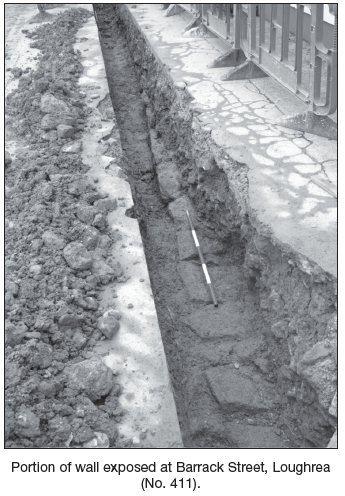
Monitoring of excavations associated with the Bord Gáis feeder and distribution mains for Loughrea and environs was carried out from July to October 2009. A number of archaeological features were identified. The most significant of these were the two sections of walling uncovered at Barrack Street. Cartographic evidence suggests that the west section, which measured 11.3m in exposed length, may be associated with the constabulary barracks. However, the section of wall revealed 14m further east and measuring 7m in length does not relate to any previously recorded building. Both sections of wall are of similar construction, orientation and alignment. Should these represent a single wall, its minimum length is 32.3m. Excavation was limited to the width of the trench required for the proposed works; hence the width of the wall was not exposed. As the site of Loughrea Castle is recorded in this general area, we cannot discount the possibility that the walls uncovered at Barrack Street are associated with the castle. There are many instances around the country where castles were used by the constabulary as sites for their barracks. Preservation in situ was achieved by covering the exposed sections of walling with geotextile membrane and sand before laying the gas pipe.
A ditch exposed during monitoring at Danesfort Road may be associated with GA105–049 (ecclesiastical remains). The ditch was cut into the orange/brown clayey sand and rock within the area identified as a potential location for an Early Christian enclosure. It measured 9m wide at the top narrowing to 6.5m at the base and was 1.8m deep. (The unusually large dimensions of the exposed section of the ditch may be a result of the pipe trench cutting the feature at an oblique angle.) The ditch was flat-bottomed and contained a single fill comprising dark-brown silty clay with mottled inclusions of silty sand with occasional charcoal and animal bone throughout. No finds were recovered to date this feature and there was insufficient charcoal retrieved to achieve a radiocarbon date. Other features recorded at various locations within the town included five pits, which were recorded in section, and several stone-lined culverts.
A deposit of burnt material was recorded in section at Colesgrove on the N6 Loughrea– Craughwell road. The deposit was sealed by a compact fill of sand and stone. It consisted of dark-brown/black silty clay with much charcoal and moderate inclusions of burnt stone, typical fulacht material. The deposit measured 3.4m long and 0.32m deep. There is no surface trace of a fulacht fiadh in the field to the south of the trench.