2009:326 - DUBLINIA (The Former Synod Hall), St Michael's Hill, Christchurch, Dublin
County: Dublin
Site name: DUBLINIA (The Former Synod Hall), St Michael's Hill, Christchurch
Sites and Monuments Record No.: DU018–02081–02025
Licence number: 09E331
Author: Linzi Simpson, Margaret Gowen & Co. Ltd.
Author/Organisation Address: 27 Merrion Square, Dublin 2
Site type: House - 17th/18th century and House - medieval
Period/Dating: Multi-period
ITM: E 715058m, N 733963m
Latitude, Longitude (decimal degrees): 53.343372, -6.272102
Dublinia is located within the core of the historic walled city of Dublin, adjacent to Christchurch Cathedral. This important site was originally the location of the church and graveyard of St Michael of the Hill and was also the palace of the Archbishop of Dublin, established by Bishop Dúnan in the 11th century. The church was comprehensively rebuilt in 1670 (although the medieval tower was left intact) but demolished during the construction of the Synod Hall in 1875, with only the tower being retained in the new build. Rocque’s map of 1756 depicts surviving grave-slabs on the northern side of the present building, indicating the presence of the graveyard in this location.
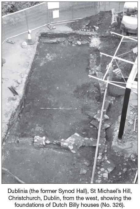
The building is now an interpretative centre and planning permission was granted for a replacement porch at the main entrance, in the courtyard, on the north side of the building. An assessment and impact statement established that there were medieval organic deposits along the southern side of the yard with post-medieval structural remains evident on the northern side. As the new structure was to be piled (mini-piles) to preserve the organic remains, it was decided to excavate the footprint of the new build to identify the location of the post-medieval walls with a view to avoiding them in the piling layout.
The excavation exposed the remains of two late 17th/early 18th-century Dutch Billy houses that fronted on to St Michael’s Hill, on the western side of the site. The remains of the main walls and a central chimney stack, containing four triangular chimneys, survived to at least 0.6m in depth, with evidence of a laneway and yard in the central area, extending to the east. The south-east corner of the excavation, however, exposed medieval organic deposits lying just 0.3m beneath the yard level, suggesting that there were no post-medieval cellared buildings in this location. A service trench established that these deposits were at least 2m in depth with evidence of a substantial hearth, perhaps suggesting the presence of a house in this location, dated to the 11th or early 12th century (Hiberno-Norse levels). What was also established was that this area was outside the graveyard attached to the medieval church of St Michael.
The walls were surveyed in CAD and provided to the design team and the piling layout was altered to avoid the walls. The walls were sealed with a buffer of stone and preserved in situ.