2009:318 - DUBLIN: St James' Hospital, Mount Brown, Dublin
County: Dublin
Site name: DUBLIN: St James' Hospital, Mount Brown
Sites and Monuments Record No.: N/A
Licence number: 08E1021
Author: Fintan Walsh, Irish Archaeological Consultancy Ltd.
Author/Organisation Address: 120b Greenpark Road, Bray, Co. Wicklow
Site type: Hospital
Period/Dating: Post Medieval (AD 1600-AD 1750)
ITM: E 713562m, N 733803m
Latitude, Longitude (decimal degrees): 53.342258, -6.294610
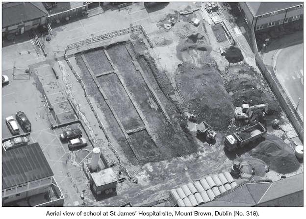
Testing was carried out at the site of a proposed radiotherapy treatment facility at St James’ Hospital, which is located at Mount Brown, Dublin 8. Three test-trenches were excavated across the proposed development area during February 2009. The testing uncovered the remains of three north-northwest/south-south-east-running walls (Walls A–C) which were encountered in each of the three trenches. These walls represent the remains of a 19th-century school which is first depicted on the second-Aerial view of school at St James’ Hospital site, Mount Brown, Dublin (No. 318). edition OS map of 1846. The school was constructed in the late 1830s or early 1840s and demolished in the first half of the 20th century.
Prior to 1837 and the construction of the school building, the proposed development area was greenfield which was later modified into gardens. The remains of these were identified by a 1m-thick deposit of soils identified across the full extent of the proposed development area. Modern china, animal bone and oyster shell were recovered from this material. A small assemblage of residual disarticulated human bone was also recovered from these soils. It is possible that these remains are pre-19th century and are associated with the city workhouse/foundling hospital and the South Dublin Union workhouse complex.
Due to the impact of the proposed development on the remains identified during testing, resolution of the site was undertaken under an extension to the original licence during May and July 2009. Resolution identified the full extent of a 19th-century school building. The extent of the school building within the limits of the development was 39m northnorth-west/south-south-east and 11m wide. It extended beyond the site limits to the north and south; however, on the basis of cartographic analysis, it would not have extended more than 10m in either direction. Small additions to the inner edges of the west and east walls of the school building may be evidence of a ledge for internal flooring, while two traversing walls between Walls A and B may indicate the presence of a room in this part of the building.
The bulk garden soil excavation failed to produce any further fragments of human bone and/or archaeological deposits.