2009:302 - CORDUFF PARK, Dublin
County: Dublin
Site name: CORDUFF PARK
Sites and Monuments Record No.: N/A
Licence number: 05E0360
Author: Judith Carroll, Judith Carroll & Company Ltd.
Author/Organisation Address: 11 Anglesea Street, Temple Bar, Dublin 2
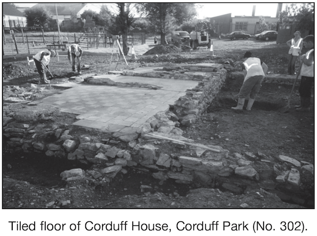
Site type: House - 17th century
Period/Dating: Post Medieval (AD 1600-AD 1750)
ITM: E 707812m, N 739809m
Latitude, Longitude (decimal degrees): 53.397412, -6.378869
Monitoring and excavation were carried out between August and December 2009 in advance of the construction of a childcare centre on the grounds of Corduff Park, Blanchardstown, Dublin 15, for Corduff Childcare Services Ltd. The site is located to the north-east of Blanchardstown, Dublin 15. It is on the former Corduff estate, the grounds and demesne lands of Corduff House. The location of Corduff House was on the highest point in the immediate area at 64.325 OD.
Previously, in 2005, monitoring and excavation were undertaken under the same licence (and managed by this company), which uncovered part of the remains of Corduff House (Excavations 2005, No. 392). Further remains of Corduff House were uncovered during this phase of excavation, as well as a limekiln and earlier contexts.
The site of the development is located in the vicinity of DU013–025, a dwelling. The RMP files refer to the large house and gardens figured on the Down Survey maps of c. 1655, in the Corduff Demesne. The exact position of the 17th-century house in the estate is not clear, but it is suggested in the files that it may be on the site of, or incorporated into, the demesne house which existed there. Rocque’s map shows the demesne in 1760, but does not further clarify the position of the major house. The position of Corduff House in the early 19th century is recorded on the first-edition OS map and again in the early 20th century on the 1910 OS map. From this series of maps it would appear that the precise location of Corduff House within Corduff Demesne has changed considerably over time.
The barony of Castleknock was granted to Hugh Tyrrell by Hugh de Lacy, who came to Ireland in 1171. The Tyrrell family appears to have prospered on the lands throughout the 13th century. During this time a number of families were established on the Castleknock lands, either by grant from the crown or from the Tyrrells. To the north-west, at Corduff, was the family of de la Felde and, at Abbotstown and Blanchardstown, the families of Abbot and Blanchard, from whom these areas derived their names (Ball 1920, 8–11). At the close of the 14th century the de la Feldes were still found at Corduff (ibid., 15). Though there were great changes in the lands forming the barony of Castleknock in the following centuries, as described by Ball, the de la Feldes were still at Corduff at the end of the 16th century: ‘In the last decade of that century [they] sent a mounted archer from it to a hosting at Tara’ (ibid., 17). Early in the 17th century, Corduff become the residence of the Warren family, who lived there for the next two hundred years.
During excavation and monitoring, portions of Corduff House were uncovered. Further excavation of the underlying ground levels revealed the presence of earlier archaeological deposits. A stone-walled structure below the Corduff House was uncovered. This structure truncated an earlier field boundary/ditch, which was one of the earliest archaeological features visible in the levels of the site. To the south-east of Corduff House a limekiln was uncovered, one of the flues of which lay underneath Corduff House at its eastern corner.
Reference
Ball, F.E. 1920 A history of the County Dublin. Vol. 6.