2008:1315 - GREYSTONES: Greystones Harbour, Wicklow
County: Wicklow
Site name: GREYSTONES: Greystones Harbour
Sites and Monuments Record No.: N/A
Licence number: 08D011; 08R043
Author: Rex Bangerter, The Archaeological Diving Company Ltd.
Author/Organisation Address: Brehon House, Castlecomer, Co. Kilkenny
Site type: Quay and Pier/Jetty
Period/Dating: Modern (AD 1750-AD 2000)
ITM: E 729522m, N 712871m
Latitude, Longitude (decimal degrees): 53.150588, -6.063580
A detailed survey of Greystones Pier and elements of the surrounding harbour area was undertaken prior to proposed alterations to the harbour environment as part of the Greystones Harbour Development Scheme. Greystones Pier represents the amalgamation of two 19th-century structures and a 20th-century alteration to the harbour design. While the overall structure does not retain any specific archaeological significance, the harbour is of historic interest; even the section of lighthouse (dating to 1966) forming the pier roundel would be of interest to industrial archaeologists of the recent past. As such, the various elements comprising Greystones Pier and the wider harbour area were surveyed to provide a detailed account of the existing harbour environment prior to its development.
Three distinct build phases were identified for the area under assessment.
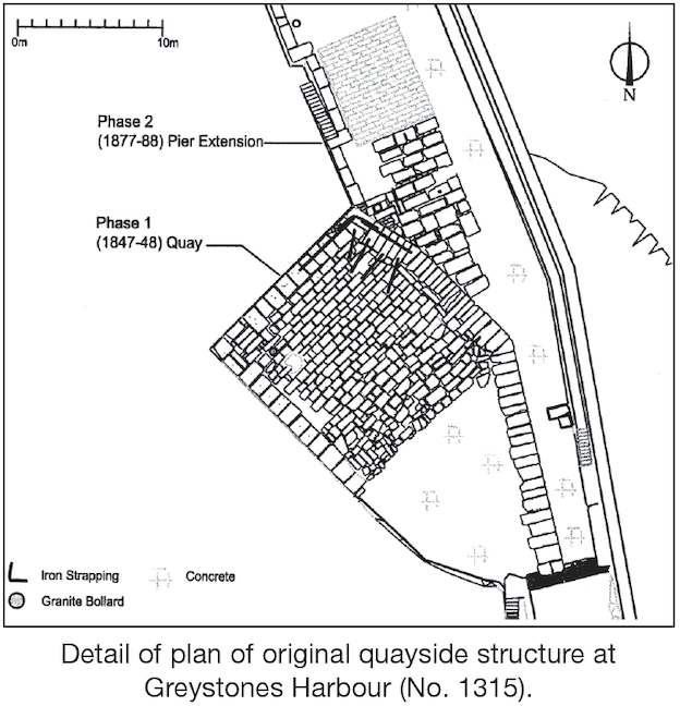
Phase 1: quayside (1847–88)
This comprises a masonry pier structure measuring 28m (91.8ft) in length, 15.3m (50ft) in maximum width and 2.31m (7.5ft) in maximum visible depth. The structure is built upon a natural spit of greywacke stone running seaward in a north-north-west direction, the extent of the spit being visible within the fabric of the western façade of the quay structure. The original parapet adjoining the quay structure was removed during the pier extension works of 1887–8, the masonry from the parapet being reused as part of the Phase 2 construction. In addition, the outer, seaward, façade of the quay is obscured by this later build, the original line of the quay only being visible in plan.
Phase 2: constructions (1887–8)
Four components to the 1887–8 undertakings within Greystones Harbour were identified. These include an extension to the original pier to measure 60m (200ft) in length by 10.6m (35ft) in width (exclusive of the pier parapet), two sets of quayside steps, six mooring posts, a 47m (156ft) by 6m (20ft) boat slip, a 108m (356ft) concrete groin (the north wall), and the quarrying of an inner dock immediately to the south-west of the quay structure.
Phase 3: roundel (1966–70)
The 1966–70 works constitute the placement of a section of the Kish Lighthouse and extensive rock armouring of the northern end of Greystones Pier. The lighthouse section is located at NGR 32958 212898 (centre-point) and forms the roundel of the north-west terminus of the 1887–8 pier.
An underwater assessment was undertaken along the outer base of Greystones Pier, the approach channel and either side of the North Wall. This was undertaken to investigate the in-water elements of both structures and to identify any submerged archaeological structures/objects or deposits that may be impacted on by the proposed alteration to Greystones Pier as part of the harbour development. The seabed survey extended a minimum of 10m from the base of each of the structures. The inner harbour area, adjacent to Greystones Pier, was accessed at low water and negated the need for dive survey.
The intertidal and land-based survey used a number of methods to create a detailed paper record of the existing harbour environment, incorporating all phases of construction within the harbour. The primary focus of the survey was to create a series of detailed drawings of Greystones Pier, recording the historic elements of the structure. This was undertaken using a Topcon differential GPS and a reflector-less Leica Total Station, supplemented by photographic and hand-drawn elements, to produce a series of detailed plans/elevations.
A detailed plan of the Phase 1 Quay was made using a differential GPS receiver, recording the structures surface at a stone by stone level. This plan was extended to include any historic masonry located along the Phase 2 (1887–8) pier structure and all fixtures and fittings located upon the entirety of Greystones Pier. An outline survey of all elements of Greystones Pier (Phases 1–3) and the adjacent quarried inlet was also carried out. A number of cross-sections/profiles were also taken through the pier structure and inlet area.
A series of datum points were fixed to the two exposed quayside elevations of the Phase 1, 1847–8, structure (at 1m intervals) to allow a photo-mosaic elevation of each façade to be made. The datum points were surveyed using a Total Station, allowing accurate scaling of the photomosaic and digitised elevations. Additionally, a large amount of spot-heights were captured and incorporated into the survey data to allow an accurate three-dimensional model of the harbour area to be generated. The assessment work was carried out between 10 and 12 March 2008.