2008:967 - KILTROUGH, Meath
County: Meath
Site name: KILTROUGH
Sites and Monuments Record No.: N/A
Licence number: 08E0297ext.
Author: Derek Gallagher, Irish Archaeological Consultancy Ltd.
Author/Organisation Address: 120b Greenpark Road, Bray, Co. Wicklow
Site type: Structure, Ring-ditch, Enclosure, Souterrain and Field boundary
Period/Dating: Multi-period
ITM: E 711052m, N 773134m
Latitude, Longitude (decimal degrees): 53.696099, -6.318353
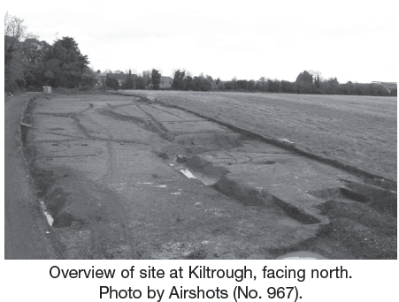
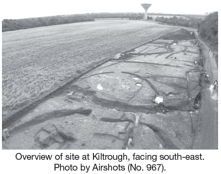
Excavation was undertaken, on behalf of Meath County Council, of sites uncovered during testing of the route of a pipeline associated with the Kiltrough water augmentation scheme. Testing had been carried out by Gill McLoughlin (IAC Ltd) (see No. 966, Excavations 2008). The archaeological remains were excavated within a narrow pipeline wayleave which was c. 30m wide. A number of the features extended outside the limit of the proposed development. The excavation was divided between Area 1 and Area 2.
Area 1 (110m by 30m)
This excavation area revealed a range of features dating from the Bronze Age, early medieval and post-medieval periods. It was located on a gentle south-facing slope.
Prehistoric/Bronze Age
The prehistoric phase included two linear ditches, each 9m long, forming a right angle which may have formed part of an enclosure or a field system. Another ditch orientated roughly east–west, and 28m long, represented agricultural activity of Bronze Age date or earlier. These ditches were the earliest features identified on-site and continued east beyond the limit of excavation.
Just south of the ditches a number of curvilinear slot-trenches were identified. These defined the outline of two structures (A and B), which have tentatively been dated to the Bronze Age. One of these structures had a clear entrance to the south-east. A similar third structure (C) with a southern entrance was located 20m west of these. Each structure had an approximate diameter of 6m, although each had been disturbed by early medieval features and only part of the structures remained. The absence of structural post-holes suggests that the structures were huts or had light roofs. Similar structures were found at nearby Colp West by Linda Clarke and Donald Murphy (ACS Ltd) (Excavations 2001, No. 952, 99E0472 ext.). Structures A and C had a drainage or enclosure trench just south of each structure which was aligned east to west. Structure A had a c. 2m subcircular metalled working platform located 2m from the entrance. A subrectangular cereal-drying kiln was found close to these structures measuring 2.6m by 1.4m by 0.7m. The firing chamber was identified and a metalled surface surrounded the outer end of the kiln.
A ring-ditch was located at the northern end of the site on an area of high ground. It was penannular in shape with a diameter of c. 16m with an entrance in the south-south-east and was associated with multiple post-holes and pits some of which contained prehistoric pottery. The northern half of the ring-ditch had been truncated by part of an early medieval ringfort ditch mentioned below.
Early medieval
The principal activity comprised a bivallate ringfort, with an internal diameter of c. 18m. Four scattered post-holes and a large shallow pit were identified within the interior. The outer ditch was exposed c. 20m to the north and had a causeway at the north-eastern end. There was no return of the outer ditch within the limit of excavation. The ditch was re–cut during a later phase of activity which altered the shape of the ringfort from circular to a much larger sub–rectangular shape. A very large pit (c. 10m diameter) was contemporary with this and had a sunken metalled surface.
A second phase of activity, identified by a recut of the ditch, resulted in the expansion of the ringfort by an extra 14m. The ringfort changed in shape to roughly rectangular with the eastern end extending beyond the limit of excavation. The extension extended across a gentle slope with higher ground to the north. A large sunken pit (4m diameter) with associated metalled surface, surrounded by a number of gullies, was located in the south-western corner of this area. This pit was located to the south of the recut ditch which allowed for the easy flow of water into the pit. A ditch attached to the south of this pit allowed water to drain away to the south. This ditch had a stone sluice gate which facilitated control of the water level within the pit.
A third phase of early medieval activity was identified by a souterrain which was cut into the backfill of the outer ringfort ditch. The entrance was identified at the eastern end, from which a passage was recorded westwards for 9m before turning south for a further 8m, and extended beyond the limit of excavation in this direction. No chambers were identified along the excavated part of the souterrain. The souterrain capstones did not survive in situ and would have been removed or collapsed in antiquity.
Four figure-of-eight kilns were identified across the site, three of which were located close to the souterrain and one located outside the ringfort (Phase 1) ditch. One kiln was set into the abandonment deposits of the entranceway to the souterrain.
A large ditch orientated north–south was identified along the western edge of the site for c. 80m and may be related to the early phase of the ringfort activity. Three enclosure ditches were found to cut this large ditch. The earliest (Enclosure I) was found in the south-west and cut Bronze Age Structure C. It was subrectangular in plan, c. 24m diameter and had an entrance to the north. The ditch was 1.5m wide and 0.5m deep. Enclosure II was similar in size to, and cut, the north-east end of Enclosure I. It was also subrectangular in plan, with an entrance in the south-east corner. Enclosure III was located 5m to the north of this. It was subrectangular in plan, had a diameter of 26m and extended beyond the limit of excavation to the west.
A further enclosure was identified to the north of the site but only part of this feature was within the limit of excavation. It was curvilinear in plan and had a diameter of 30m. The enclosure extended to the north and to the west. Souterrain ware pottery sherds were found in the fill of this ditch. The maximum width of the ditch was 2.5m with a depth of 1m.
In addition to these, c. 30 pits ranging in size from 0.6m to 3m and multiple post-holes were identified across the site. These are hard to date without diagnostic finds but an early medieval date is likely.
Post-medieval
A multitude of linear features associated with post-medieval agricultural activity were identified across the site. In general, these tended to be orientated north–south but a number were orientated east–west.
Finds associated with excavation at this site include several glass beads, souterrain ware pottery sherds and copper-alloy fragments. A small tanged iron knife, a large iron slotted and pointed object, a bone comb, worked flint blades and scrapers and a copper-alloy pin were also identified.
Area 2 (30m by 15m)
This excavation area revealed a burnt mound that comprised two troughs, a well and a number of pits, post- and stake-holes.