2008:961 - GLEBE, Meath
County: Meath
Site name: GLEBE
Sites and Monuments Record No.: ME042–020
Licence number: 07E0922
Author: Denis Shine, Cultural Resource Development Services Ltd.
Author/Organisation Address: Unit 4, Dundrum Business Park, Dundrum, Dublin 14
Site type: Ringfort - rath, Church and Graveyard
Period/Dating: Multi-period
ITM: E 679398m, N 749318m
Latitude, Longitude (decimal degrees): 53.487885, -6.803596
CRDS Ltd have been retained by Meath County Council to act as the archaeological consultants on the bundled wastewater collection system for County Meath, to be carried out in eight towns: Athboy, Donore, Duleek, Kilmainham Wood, Moynalty, Rathcairn, Rathmoylan and Summerhill. This project is expected to continue until 2009.
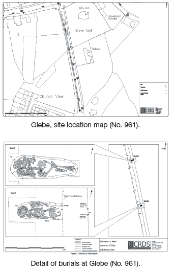
On 3 March 2008, while monitoring next to the existing Church of Ireland church (ME042–020), human remains were encountered. Following a revised method statement, excavations were undertaken from 26 March 2006 to 9 May 2008 along a 220m portion of the development/pipe trench. The trench, which averaged 1.2–1.3m wide and up to 3m deep, requiring shuttering. The archaeological features were confined to the northernmost 150m of the trench.
These features consisted of eight ditches (three of which contained recuts and one of which was revetted), ten furrows or gullies, five pits, two burials, a boundary wall, two post-holes, a possible quenching trench, a probable slot-trench, a hearth, three bowl furnaces and an early modern road surface as well as a range of deposits.
An examination of the finds indicates the features are mainly later medieval and post-medieval in date, with the most common pottery being Leinster cooking ware and Dublin-type ware, dating to the 12th–14th centuries.
The width of the excavation, c. 1.2m, makes its interpretation difficult but it is currently thought that some of the ditches represent a substantive enclosing element around the medieval church and settlement in Rathmoylan. A medieval foundation by the Hospitallers in Rathmoylan is recorded in a letter from Pope Innocent III dating to 26 June 1212 (Sheehy 1965, 148–9). The exact location of this foundation was not previously known, although it was speculated that it could be at the site of the current Church of Ireland structure. The weight of archaeological evidence uncovered at Rathmoylan seems to confirm there was settlement in this area in the 13th and 14th century which could potentially be related to this foundation.
Several of the ditches appear to divide the site into ‘areas of activity’, with possible light industry represented by the slot-trench, hearth, bowl furnaces and quenching trench and cultivation or agriculture represented by two concentrations of furrows and gullies. All these areas are clearly defined and appear to be bounded by ditches. Post-excavation analysis is ongoing but the absence of post-medieval finds from these areas seems to infer that most of these features are later medieval in date.
These features are more likely to represent a mixed-use settlement rather than a distinct ecclesiastical site associated with the Hospitallers. However, in the post-medieval and early modern periods the church precinct was certainly bigger than it is at present. Two intact burials as well as quantities of disarticulated bone were recovered from the pipe trench immediately west of the present churchyard. One of these burials, identified as a female, was buried with a smoker’s kit, including a flint nodule, strike a light and a clay-pipe bowl. This bowl has been dated to c. 1640–1660, probably giving an approximate date for both burials.
In addition to the burials the boundary wall of the graveyard was shown to continue originally west across the current road. A ditch to the immediate south of this wall may have acted as an earlier boundary on the graveyard. An early modern road surface was also recorded in both section faces. This terminated where the southern boundary of the graveyard extended underneath the current road. This appears to correspond to a map produced in 1767 by Bernard Scalé, which seems to show that the road originally only came to the southern boundary of the graveyard before turning east around the church precinct. By 1812 Larkin’s map shows that the current crossroads in Rathmoylan were established and the graveyard had contracted east. It seems likely that this may have happened around 1797, when the current Church of Ireland structure was constructed.
References
Sheehy, M.P. 1965 Pontifica Hibernica: medieval papal chancery documents concerning Ireland 640–1261, vol. 1.
Larkin, W. 1812 A map of the County of Meath in the province of Leinster in Ireland.
Scalé, B. 1767 The glebe of Rathmalion. In A survey of the Lordship of Athboy in the Barony of Lune and County of Meath. The Estate of the Right Honourable John Earl of Darnley.