2008:938 - ATHBOY: Townparks, Meath
County: Meath
Site name: ATHBOY: Townparks
Sites and Monuments Record No.: N/A
Licence number: 08E0865
Author: Denis Shine, Cultural Resource Development Services Ltd.
Author/Organisation Address: Unit 4, Dundrum Business Park, Dundrum, Dublin 14
Site type: Enclosure, Quarry, Field boundary and Burial ground
Period/Dating: Multi-period
ITM: E 672080m, N 763895m
Latitude, Longitude (decimal degrees): 53.619911, -6.910488
CRDS Ltd have been retained by SIAC to act as the archaeological consultants on the DBO contract for the bundled wastewater collection system for County Meath, to be carried out in eight towns: Athboy, Donore, Duleek, Kilmainham Wood, Moynalty, Rathcairn, Rathmoylan and Summerhill. This project is expected to continue until 2009.
Human remains were encountered in Townparks, Athboy, on 18 September 2008 while monitoring the construction of an access road to a new wastewater treatment plant for Athboy, located in Townparks townland (see No. 935, Excavations 2008, 07E0919). Monitoring works for the plant were completed in March 2008 and no remains of archaeological significance were noted. The access road is c. 8m wide and 160m long with a temporary wayleave of 20m. This access road runs from the Trim Road, west down a natural slope, across an area of natural peat up to 1.4m deep, and across the line of the disused railway, to the wastewater treatment plant situated beside the Athboy River. The archaeological remains were exposed at a high point adjacent to the Trim road.
Construction works were stopped in the area of the burials and these were subsequently excavated under a separate licence.
Excavations were undertaken from 6 October to 19 December 2008 by a team of eleven archaeologists. In total 158 features were identified on-site, in four main phases.
Possible prehistoric features
Three pits, a single burnt deposit as well as five hill-wash deposits were recorded located to the west of the site on a west-facing slope of the hill as it approached a bog. These features have been tentatively dated as prehistoric by a single lithic find within the burnt deposit. This deposit was truncated by two smaller pits. A third larger pit, exposed to the south, was truncated by the large adjacent medieval ditch providing some relative dating. However the date of all these pits is speculative in advance of radiocarbon dating. The five hill-wash deposits are truncated by the medieval ditch and may also be prehistoric in date.
Medieval features
Two significant medieval features were exposed: a substantial ditch, most likely an agricultural drainage/boundary feature, and a large pit provisionally interpreted as a gravel/sand extraction pit.
The ditch was exposed at the western end of the site and contained significant quantities of medieval pottery in its fills. It seems likely to have formed a drainage and/or boundary feature, separating the well-drained land of the high ground – suitable for arable agriculture – from the bog/peat areas to the west. The ditch extends to the north and south beyond the limits of excavation but there was no visible sign of it on the ground, in cartographic sources or aerial photographs or in a topographic survey of the field.
The fills of the ditch suggest it remained an open feature for some time, probably being cleared out at regular intervals.
A large irregular shallow pit exposed c. 18m to the east has been provisionally interpreted as a gravel/sand-extraction pit. The primary fills of this pit contained medieval pottery; a stick-pin was recovered from the secondary fills. The pit was cut into the ridge of high ground into a pocket of sand. This suggests its primary purpose was to extract gravel or sand, presumably to make lime mortar. Gravel and sand extraction continued in the area into the historic period: gravel pits are shown on the first-edition OS map directly south of the site. An episode or episodes of burning was identified in the base of the quarry pit, probably from a hearth. The level of vitrification indicates this was not intense or prolonged.
Modern features
A ditch was found beside the Athboy–Trim road; it contained modern pottery. This ditch appears to have been replaced by the current bank and hedge field boundary. A modern ditch was also found next to the medieval ditch separating the low-lying wet ground from the higher dry ground. Both ditches extended beyond the excavation limits, however their line could not be followed on the ground, in aerial photographs or maps or through topographic survey.
Three large modern field boundary ditches were exposed to the west of the excavation during monitoring. Their location corresponds to a field boundary depicted on the 1837 OS map. Fragments of clay pipe recovered within the ditches indicate a late date. These boundaries were subsequently removed to allow the construction of the railway line which opened in 1865.
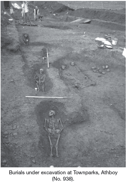
Burials
In total nine burials as well as 29 bags of disarticulated human bone were recovered from the site. All but one of the burials identified were contained within identifiable grave-cuts and backfilled with single fills. All the burials were extended and all were orientated broadly east–west. Finds dated as 18th–19th-century pottery sherds were recovered in association with three of the burials. The burials were concentrated in three groupings of four, three and two individuals. These groupings could represent family groups or different phases of burials. However, it is more likely these groupings are not significant. Only one stratigraphic relationship was recorded where one burial was clearly cut through another.
An osteoarchaeological report is being prepared for the burials. However, it has been provisionally noted that, of the seven burials with an intact skull, all were missing their third molar. Most of the burials appear to be juvenile/young adult and it is not unusual for the third molar not to have erupted at this point. However, the missing third molar can also be a genetic trait, possibly suggesting the burials are related. Only one adult burial was missing its third molar.
The burials on-site were widely spaced. The nearest church site is located 0.63km west of the site and there is no tradition of a burial-ground at the site. It may be that the burials extend beyond the limits of excavation. It seems likely that the burials represent a smaller—possibly family-based—modern cemetery or a small informal burial group, possibly even famine burials. This would help explain the relatively short usage of the site and the fact that it is not definitely demarcated or recorded in any historical records.