2008:825 - DROGHEDA: South Bank Development, Marsh Road, Louth
County: Louth
Site name: DROGHEDA: South Bank Development, Marsh Road
Sites and Monuments Record No.: N/A
Licence number: 08E0031
Author: James Kyle, Irish Archaeological Consultancy Ltd.
Author/Organisation Address: 120b Greenpark Road, Bray, Co. Wicklow
Site type: Religious house - Carmelite friars
Period/Dating: Late Medieval (AD 1100-AD 1599)
ITM: E 709352m, N 775073m
Latitude, Longitude (decimal degrees): 53.713871, -6.343394
The excavations at the South Bank development site took place from April to September 2008 and were carried out as part of Phase 2 of the Scotch Hall project. The earliest element of archaeology uncovered on-site was a substantial east–west-oriented wall, 1.8m in width, constructed of faced, cut limestone blocks bonded by clay mortar and rubble infilling. This wall possessed a substantial sloping batter on its northern face. It was constructed directly onto river silts and present on-site for c. 40m, in varying degrees of preservation due to disturbance of this area during the post-medieval period. It is possible that this wall may have been an extension of a quay wall, or perhaps associated with the medieval town wall, the site of which is located c. 200m to the west.
In the south-east corner of the site, abutting the northern face of this east–west wall, were the remains of a building with possible outlying walls, all of which were constructed on a north–south orientation. This would have possibly led or have been adjacent to the River Boyne. The remains consisted of the ground-floor plan of a relatively complex building, constructed on a multi-phased basis, comprising a small room-like structure, which may have been the base of a tower. This was accessed by a long north–south intramural passageway, with an annexe, which may have been a room in its own right. However, this may have provided access to a potential staircase-type feature, which suggests that this was more than a single storey construction.
Much of the eastern side of the building may have been open at this level, as there was little evidence for a contemporary enclosing wall on this side. Equally the remains of a substantial stone pillar on this side of the building may suggest a vaulted pillar element to the structure.
To the west of the structure were two north–south oriented walls, which may have defined yard areas or gardens associated with the structure. The closest of these again being possibly tied to the structure via a pillar which may have formed an archway or roof support. All of the walls were of similar construction; coursed and faced cut limestone blocks, bonded with clay mortar and rubble infilling. Occupation of this area was clearly problematic due to its proximity to the river, as a clearly contemporary land filling effort was evident within the structure and the surrounding area to raise the ground level above potential water levels. Ultimately this may have been reason enough to abandon the site, which can be at best described as marginal ground.
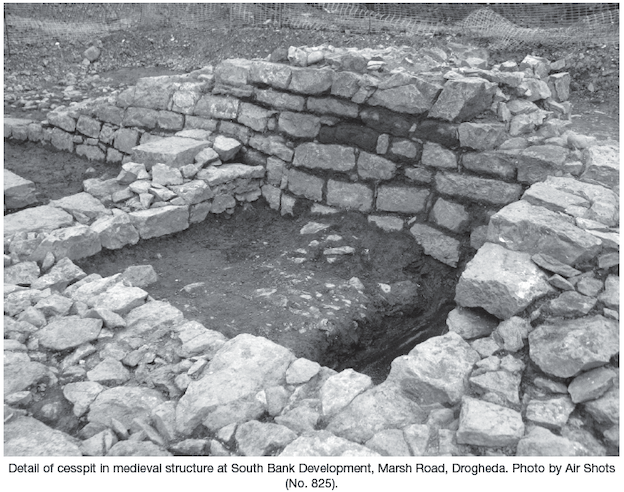
A cesspit was discovered within the south-east corner of the structure. This was fully excavated to reveal deposits containing well-preserved organic remains, including mosses, a wide variety of seeds and preserved timbers and planks. Other finds include a wooden bowl and utensils, a substantial quantity of 12th- to 14th-century pottery imported from Saintonge (south-west France), Bristol (south-west England) and domestic Irish wares with tiles manufactured in the locale of Drogheda. Examples of these have been uncovered on several excavations of ecclesiastical sites in the town and surrounding area.
Whilst the cesspit appeared to be stratigraphically later than the bulk of the structure, it may have been in use close to or immediately after the decline or demolition of this structure. The finds from the cesspit coupled with those from the building itself (most notably a carved wooden stylus and iron key) are suggestive of a religious or relatively high status structure dating to the 13th–15th century. It was difficult to assess the full extent of the structures on-site due to the heavy level of 20th-century disturbance to the north and west and indeed the current site limits to the west.
A full record has been made of the structure and its associated walls and they have now been preserved in situ, whilst more archaeologically sensitive contexts such as the cesspit have been fully excavated. Research with regard to the site and its discoveries is ongoing. The apparent abandonment of the structure and its subsequent demolition or collapse would appear to have taken place prior to the production of Barnaby Goche’s map of Drogheda (1574).
It is tempting to suggest that due to the location of the structure, outside of the town walls, close to the Marsh road and the position of St James’s Gate, this site may represent structures associated with the Priory of St James, a satellite foundation associated with the Abbey of St James. This complex may have been a hospital catering for the sick and the leprous in this area of the medieval town, which would explain its position outside of the walls.
Barnaby Goche’s map of 1574 depicts St James’ Abbey on the southern side of the Boyne within the town walls, located approximately south-west of St James’s Gate. The abbey is depicted as a large east–west-oriented structure with a tower abutting the eastern elevation of the structure. The abbey precinct is enclosed by a rectangular-shaped wall that abuts the western elevation of the eastern town walls.
Kieran Campbell’s excavations at James Street between 1981 and 1984 (Medieval Archaeology 27 (1983), 218–9; 28 (1984), 256; 29 (1985), 214; and Archaeology Ireland 1 (1987), 52–6, E210, E249 and E701) identified substantial medieval structural remains bounded by the line of the medieval town wall immediately east of the site (north of the site of St James’s Gate) and bounded to the west by the older defences dating c. 1186–c. 1215 along the axis of Graves Lane. The supposition put forth based on the excavation of the structural remains and examination of the documentary and cartographic sources led the excavator to suggest that ‘it is not the hospital of the same name referred to in documentary sources from 1476 onwards which was clearly outside the town walls’ (Campbell 1987, 54).
The building and associated walls were heavily disturbed during the 20th century and as such it is difficult to judge the excavated portion in isolation. After the medieval structures on-site are demolished or collapse there appears to have been a further deposition of soil to raise the ground level prior to the later phases of activity on-site. However, it is recorded that the lands of St James’s Hospital were confiscated by the Crown at this time of the Reformation and Dissolution. As such, the structures are unlikely to have been extant at the time of Barnaby Goche’s map as it post-dates the Reformation by nearly 40 years.
However, it may be possible that Goche did not illustrate the building, as it is possible it appears on Newcomen’s map of Drogheda dating to 1657. He illustrates a rectangular enclosure east of the approximate location of the South Bank site entitled ‘Abbey Park’. There appears to be a north–south-oriented structure on the eastern boundary of the Abbey Park, which may be located within the south-east potion of the South Bank site and could be a depiction of the structural remains found on-site.
A second phase of activity occurred to the south of the structure and medieval walls, and this comprised 28 human burials in the Christian tradition, divided into three north–south rows, with 10m between each row. The burials were stratigraphically later than the demolition/collapse of the medieval walling. These were simple, relatively well-organised graves, with some examples having up to three individuals buried in the one grave-cut. Finds retrieved from the graves span the medieval and post-medieval periods and as such are inconclusive as datable evidence as to the age of these burials. Preliminary osteoarchaeological analysis of burials has suggested that they may be of medieval date, but further study is needed and the sample group may only be a small portion of the total cemetery, and as such relatively inconclusive.
A final phase of archaeological activity was present adjacent to the south-west corner of the site along the Marsh road frontage. A large amount of medieval garden soils had been deposited in this area. These were mostly not in situ as there was evidence for 19th-century tanning activities present below the deposition horizon. A complex, area-specific finds retrieval strategy was carried out on the excavated garden soils, which included metal detection followed by manual and finally mechanical finds retrieval. A substantial quantity of medieval pottery, roof and floor tiles, metal objects (including a partial cannonball) and numerous other artefacts were recovered. These predominantly dated to the medieval period with some later inclusions probably relating to the disturbance and movement of these contexts from their original locations.