2008:428 - DUBLIN: 31–36 Ormond Quay Upper/Ormond Place/Charles Street West/Ormond Square, Dublin
County: Dublin
Site name: DUBLIN: 31–36 Ormond Quay Upper/Ormond Place/Charles Street West/Ormond Square
Sites and Monuments Record No.: DU018–020
Licence number: 04E1206 ext.
Author: Teresa Bolger
Author/Organisation Address: 49 Hybreasal, SCR, Dublin 8
Site type: Historic town
Period/Dating: Multi-period
ITM: E 715596m, N 734317m
Latitude, Longitude (decimal degrees): 53.346440, -6.263890
Monitoring and excavation were carried out at a development site at 31–36 Ormond Quay Upper/Charles Street West from January to March 2008, continuing on from an initial programme of works in 2007 (Excavations 2007, No. 495). The site is within the zone of archaeological potential for the historic town of Dublin, located to the south of the medieval suburb of Oxmantown, at the western edge of the confluence of the River Liffey and River Bradogue, in an area referred to during the medieval and early post-medieval period as ‘the Pill’. Extensive redevelopment and land reclamation was undertaken in this area in the late 17th century to create the modern topography and streetscape, including the walling in of the river and the construction of the modern quay-frontage.
Phase I
The earliest activity identified during the excavation was localised in the south-east quadrant of the site at a level between c. –1.2m OD and –1.8m OD, where a timber-laced or reinforced embankment with associated pathway was set into the primary silt deposit.
The main wooden structure extended roughly east-north-east to west-south-west for c. 15m in the south-east quadrant of the site. It extended beyond the limit of the excavation to the east and south. The eastern part of the structure was somewhat wider and disorganised in its build, measuring 5m in width, while the western part, which was narrower and more structured, measuring 3.5m in width. The structure comprised three main elements: long, roughly angled to horizontal sails, horizontal rods and upright pegs. These elements appeared to function as one single build, incorporated into and holding the gravel bank material in place.
The natural river gravel deposits appear to have been simply thrown up to form a low bank at the waterfront, running in a roughly east-north-east to west-south-west orientation. Long wooden sails had then been placed perpendicular to the river frontage atop this small bank, with the northern ends driven into the underlying estuarine silt, spaced some 0.3–0.5m apart; rods had been interwoven throughout the length of the sails, giving the structure the form of a loosely woven wooden mesh. Short wooden pegs were driven through the southern edge (riverside) of the mesh along its length to secure it across the top of the embanked gravel. Another layer of the same gravel material had then been thrown upon the wooden mesh to further add height to it and another layer of sails were incorporated in the same manner as the before. More rods had been interwoven to the south to attach the lower level of wooden sails to the upper level and other rods had similarly been woven into the sails along their lengths. In all, this process appears to have been repeated at least three times to construct the bank with the curvature of the sails and wooden mesh becoming more pronounced through the upper levels. A cross-section of the bank showed the various lenses of built-up bank material with the incorporated sails and rods. It also showed the sails becoming more angled and less horizontal the further up into the bank they have been built, resulting in a northern slope towards the higher ground and a rather straight, vertical edge of sails and rods to the south.
A continuous length of wattle panel/hurdle extended along the base of the embankment on the landward side; it was 6.72m long, extending nearly half the total length of the embankment, and was 1.15m wide.
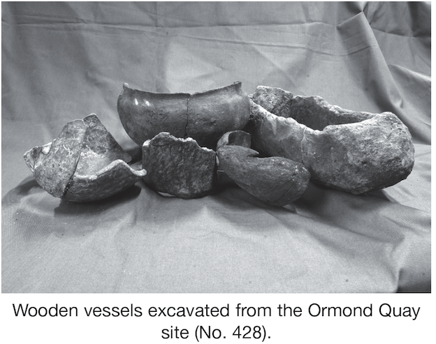
Two lathe-turned bowls were associated with the embankment; both are globular in shape with everted rims. One bowl was found on the north side of the embankment and the other was at the very north-western end of the wattle panel between Sails 24 and 25. These bowls are similar in form to Late Iron Age bronze bowls, such as the bowl from Keshcarrigan, Co. Leitrim (Earwood 1993, 62–4).
The embankment was sealed by later deposits of river gravel and silts.
Phase II
The second main phase of activity at the site was characterised by the construction of a rough brushwood surface, located at c. –0.289m OD in the south-eastern and south central sections of the site. The surface was characterised by a large, east–west-orientated area of partially surviving concentrations of brushwood measuring some 19.24m long, 12.36m wide and 0.15m deep. The wooden surface had been deposited on top of a substantial alluvial deposit and subsequently become sealed by loose orange sandy gravel. The entire surface appears to have been affected by flooding, washing away large segments of the brushwood surface, leaving somewhat scattered and sparse remains. The surviving remains had a mainly east–west orientation located directly north of the River Liffey waterfront. The brushwood was aligned north–south having been placed tightly together to form a flat, coherent surface. At c. 12.5m from the east, the surface appeared to branch off in a concentration of brushwood running towards the north-west, with the individual timbers aligned north-west to south-east.
The timbers themselves ranged in size from as little as 0.06m up to 0.99m long and represented anything from little thin twigs to large branches. Bark, crushed wood and wood chip was embedded in between the brushwood, working as padding material to create an even surface. The main concentration of brushwood was located in the eastern part and along the very southern extent of the development site. The surface appeared to continue beyond the limit of excavation to the south. Incorporated into the brushwood surface were a number of larger timbers. There was no evident pattern to these timbers and they appear to simply be part of the main feature, placed at the base and subsequently sealed and surrounded by smaller brushwood.
Three wooden artefacts were retrieved from within the wooden surface. Two of the finds were identified as wooden vessels, one complete trencher and one partial carved bowl.
The surface was sealed by later deposits of river gravels and silts.
Phase III
Extensive land reclamation had been carried out during the late 17th century. This reclamation was characterised by dark-brown, almost black, clay silt with inclusions of a substantial amount of post-medieval material, at levels between c. 10.4m OD and 11.7m OD. Two distinctive phases of reclamation could be distinguished, an upper and a lower. The lower deposit was much siltier in character and contained mainly unglazed roof tile and only the occasional pottery or clay pipe. The upper level was somewhat more organic in character and contained very little roof tile but frequent amounts of post-medieval pottery and clay pipes.
Phase IV
The fourth phase of activity at the site comprised the structural remains of 18th–19th-century buildings. These remains survived primarily in the southern half of the site. Redevelopment of the site in the late 19th to 20th century had resulted in the removal of most of this material from the northern half of the site.
The basement foundations and floor surfaces were located at c. 11.73m OD cut into reclamation material. When the survey of the recorded structural remains was overlaid onto the first-edition OS map of the block, there was a direct correlation between the surviving remains and structures indicated on the map. Six buildings are shown fronting onto Ormond Quay (Nos 31–36); Nos 32–36 appear to be broadly similar in size with No. 31, only half as wide as the rest. A similar arrangement of plots and buildings is illustrated on Rocque’s map of 1760, suggesting that the Ormond Quay frontage of the block remained largely unchanged. Structural remains associated with each of these buildings were identified during the excavations. The surviving remains of structures fronting onto Charles Street were much less well defined than those fronting onto Ormond Quay. Some structural remains mainly associated with Nos 1 and 2 were identified.
Reference
Earwood, C. 1993 Domestic Wooden Artefacts in Britain and Ireland from Neolithic to Viking Times. University of Exeter Press, Exeter.