2008:405 - DUBLIN: Fishamble Street/John’s Lane South, Dublin
County: Dublin
Site name: DUBLIN: Fishamble Street/John’s Lane South
Sites and Monuments Record No.: DU018–020–077
Licence number: 08E0042
Author: Linzi Simpson, Margaret Gowen & Co. Ltd.
Author/Organisation Address: 27 Merrion Square, Dublin 2
Site type: Historic town
Period/Dating: Multi-period
ITM: E 715210m, N 734078m
Latitude, Longitude (decimal degrees): 53.344372, -6.269771
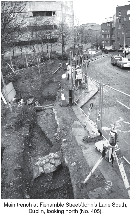
Monitoring and excavation took place at the junction of Fishamble Street and John’s Lane South (within the grounds of the Dublin Civic Offices) to facilitate emergency works after a main water pipe unexpectedly burst. This area is centrally located within the medieval town of Dublin forming the port area from the late 12th century onwards. John’s Lane South represents an original medieval lane which ran along the northern side of Christ Church, the medieval cathedral within the city walls. The medieval church and graveyard of St John was located at the top of Fishamble Street, on John’s Lane South, and was an important parish church throughout the Middle Ages. It was only demolished in the 19th century, although it had undergone several rebuilding phases including the addition of a fine Palladian façade in the 18th century. After the works described here were completed, the church foundations were carefully backfilled, protected and left in situ.
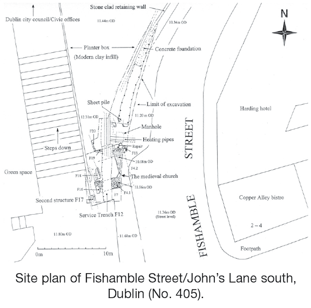
The monitoring and excavation at the top (southern end) of Fishamble Street exposed the remains of a masonry build thought to be part of the medieval church. The extant remains consisted of a well-built rectangular structure measuring externally 6.3m north–south by 5m wide with evidence of a rebuild in the medieval period. The walls measured 1.5m in width by between 0.75m and 0.2m in height. This structure had been exposed previously as part of the Wood Quay archaeological campaigns in the 1980s but had been carefully backfilled and sealed. Despite this, the remains were badly damaged by the insertion of various services throughout the years.
The structure only survived as foundations and was composed of mortared limestone block, the natural bedrock in Dublin. There was a small projection at the exposed eastern end of the build and this resembled some sort of anta, although it was not flush with the corner and there was also evidence of a post-hole. In addition to this, the corners were rebuilt at some stage in the medieval period, possibly during the documented programmes in 1350, 1477 and 1589.
The general external width of 6.3m suggests that this build may represent the eastern end of a small church, possibly a two-cell structure comprising a nave and a smaller chancel at the eastern end. Thus the square build was probably the chancel. A similar small church was located during the excavations at St Audoen’s Church, Dublin, which was built a short distance to the west in c. 1200 (Mc Mahon 2006, 86). St Audoen’s had a long nave, measuring 15.5m long by c. 8m in width, but with a smaller chancel at the eastern end, measuring c. 6.5m in width (ibid. 88). Alternatively, the square may also have been a tower on the medieval church as there is a record of a tower in the 17th century at the eastern end, which held a clock in the 18th century (Pearson 2002, 243). However, the cartographic sources (Speed 1610 and De Gomme 1678) suggest that this was at the western end, which is the normal location for such a tower.
The square structure was demolished in the 18th century and at least two walls were subsequently built, which can probably be identified with this phase of the works, although both walls were very different in type. The demolition was carried out as part of the rebuilding of the church under George Ensor, who constructed a fine Palladian façade, which fronted on to Fishamble Street. These works evidently disturbed human remains from the graveyard on the northern side of the church but these bones had been carefully collected and placed against the south wall of the church in antiquity. A large amount of disarticulated human remains were also found within the rubble deposits inside the church, probably originally from the medieval graveyard. This graveyard was located on the northern side, as depicted by Rocque in 1756, and is mentioned in the historical sources throughout the medieval period; this graveyard was preserved in situ during the Wood Quay campaigns and is currently a green space, outside the Fishamble Street entrance to the Civic Office. The church was finally demolished in 1877 and demolition deposits spread over the foundations which were left in situ. However, there is photographic evidence to suggest that the main western wall was left standing, as it abutted terraced houses, and was subsequently reused as the main wall when the Mission Hall was built. This building was only demolished in the 1960s.
References
McMahon, Mary 2006 St Audoen’s church, Cornmarket, Dublin: archaeology and architecture. Dublin.
Pearson, Peter 2002 Heart of Dublin: resurgence of an historic city. Dublin.