2008:125 - GLENINAGH SOUTH, Clare
County: Clare
Site name: GLENINAGH SOUTH
Sites and Monuments Record No.: CL002–076001
Licence number: 08E0685
Author: Christine Grant, DoEHLG
Author/Organisation Address: Plaza Offices, Headford Road, Galway
Site type: Hillfort
Period/Dating: Prehistoric (12700 BC-AD 400)
ITM: E 519182m, N 709118m
Latitude, Longitude (decimal degrees): 53.126478, -9.207544
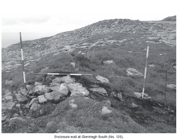
Research excavation was undertaken on a hilltop enclosure located on Ceapagh an Bháile hill on the Burren uplands, to the west of Ballyvaughan village. The monument consists of a series of discontinuous banks that enclose the top of the hill on different levels. It encloses an area of c. 150ha in extent, making it one of the largest enclosures in the country. The enclosure does not conform to the usual hillfort classifications. A preliminary survey has shown its form to have more in common with the Neolithic banks on Knocknarea, Co. Sligo (Bergh, Archaeology Ireland, Vol. 52). It is strategically placed overlooking the coastal zone and the high pastures of the Burren plateau. The purpose of the excavation is to identify and record the structural elements of the bank for comparative purposes and to retrieve dating evidence. This will facilitate a strategy for future research at the site. A preliminary survey of the enclosure was completed in 2008. The excavation area was surveyed in detail. Two small cuttings were opened in August 2008. The excavation was undertaken by hand and all excavated material was sieved.
Cutting 1 was excavated across the width of the enclosure bank. This cutting was 3m long by 1m wide. The remains of a low wall of limestone were exposed beneath the grassy bank. The wall remains are c. 1.3m wide and 0.4m high. However, the extent of the wall has not yet been fully determined. Excavation was not completed due to unusually inclement weather and time constraints. It is intended to complete this cutting in 2009.
Cutting 2 was excavated on the interior of the enclosure within a hollow. The hollow lies immediately adjacent to the bank. It may be a natural hollow or may have resulted from quarrying of stone for the bank. It was explored on the basis that it may have been used as a working area or have had material remains associated with the construction of the bank. The hollow is 4m in overall diameter. The cutting was opened at the east side of the hollow against a natural rock terrace. This cutting was 1m2 in extent and was archaeologically sterile.