2008:022 - CARICKFERGUS: Methodist Church, Antrim
County: Antrim
Site name: CARICKFERGUS: Methodist Church
Sites and Monuments Record No.: N/A
Licence number: AE/08/164
Author: Colin Dunlop, Northern Archaeological Consultancy Ltd.
Author/Organisation Address: 638 Springfield Road, Belfast, BT12 7DY
Site type: Church and Town defences
Period/Dating: Multi-period
ITM: E 741121m, N 887383m
Latitude, Longitude (decimal degrees): 54.714705, -5.809715
The site was occupied by the existing church and halls, built in 1883 and 1969 respectively. These were demolished prior to monitoring beginning on the site. Monitoring of the level reduction and excavation of pile caps and beams revealed archaeological material dating from the Mesolithic through to the post-medieval period. The archaeological material within Areas 1 and 2 was fully recorded under the remit of this licence. The material within Area 3, comprising the medieval and Elizabethan defences, was partially excavated under this licence, with the siteworks to be completed by the CAF under a separate licence during 2009.
The development site was situated on the corner of West Street and Albert Street, in the modern town of Carrickfergus, without the medieval walled town but within the later 17th-century walls.
Three areas of archaeological material were uncovered: Area 1 was to the east of the site, Area 2 to the west and Area 3 running through the centre. In addition to these three areas, several Mesolithic knapped flints were recovered from the raised beach deposits which covered much of the southern half of the site.
Area 1 contained two layers of medieval material, the remains of the 1810 Wesleyan Methodist Chapel that stood on the site until a larger Methodist church was built in 1883, a small remnant of the foundation for a building which lay immediately north of the chapel and a layer of cobbles which lay south of and abutted the south wall of the chapel.
Area 2 contained two layers of probably 18th- to early 19th-century cobbles, a late 19th-century drain and a late 19th-century wall. These features were cut by two modern sewerage pipes.
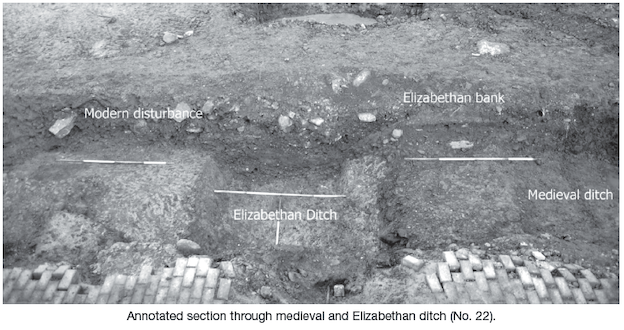
Area 3 encompassed the medieval and Elizabethan defences of Carrickfergus. The ditches ran north to south across the site, with the bank of the Elizabethan ditch partially overlying the medieval ditch. The Elizabethan ditch was c. 4m wide and survived to a depth of 1.2m; its bank was 3m wide and 0.5m deep. The medieval ditch was c. 1m wide and 0.4m deep. The east side of the medieval ditch was destroyed by the later insertion of drainage pipes, while the west side was truncated by the Elizabethan ditch, which may account for the relatively small size of this ditch. Four trenches were opened across the line of these ditches; these corresponded to the pile cap positions and were labelled Boxes 1–4.