2007:1625 - CASTLECRANNA, Tipperary
County: Tipperary
Site name: CASTLECRANNA
Sites and Monuments Record No.: N/A
Licence number: E003264
Author: Margaret McNamara, TVAS (Ireland) Ltd.
Author/Organisation Address: Ahish, Ballinruan, Crusheen, Co. Clare
Site type: Enclosure
Period/Dating: Post Medieval (AD 1600-AD 1750)
ITM: E 578540m, N 672405m
Latitude, Longitude (decimal degrees): 52.802213, -8.318246
This site was excavated in advance of the N7 Nenagh to Limerick road project at Chainage 20520–20960. Excavated sites E3265, Gortmore (pits, burnt-stone deposits, No. 1673 below), and E3266, Kilnacranna (multi-phase enclosures, cremation burials, corn-drying kiln, metalworking, pits, post-holes, linear features, No. 1696, Excavations 2007), were located to the north-east and the south-west respectively. Cranna House is located to the north-west while Cranna Castle is an unlocated site recorded in the Civil Survey. Excavations were carried out between 23 April and 29 June 2007. The new N7 traverses a gently undulating landscape of lowland pasture broken only by an area of peat basin straddling the border between counties Limerick and Tipperary. The region is overlooked by the Silvermines Mountains to the east and the Arra Mountains to the north and west. Specifically, these sites were located on flat pastureland between the two mountain ranges with particularly impressive views of the Silvermines.
Four separate areas (A–D) were excavated, totalling 7224.3m2. Due to the discovery of coins during both the testing stage in 2006 and initial cleaning of Area D, it was decided to scan all of the areas with a metal detector, enhancing the recovery of metal artefacts. Post-excavation analysis is at an early stage and the number of artefacts is likely to increase once samples have been sieved and all metal-detecting finds have been catalogued.
Area A
This area covered 553.4m2. Although a number of features were noted in this area at the testing stage, no archaeological deposits were revealed during excavation. Metal detecting of the spoil yielded three finds: a silver 1866 Victorian halfpenny, a much-corroded coin with possible harp depiction and a metal bar.
Area B
This site covered an area of 292.2m2. Four cut features (three pits and a post-hole) and seven deposits (pit fills, post-hole fills, burnt clay deposits, redeposited material) were recorded here. Two pieces of flint and sherds of glazed post-medieval pottery were retrieved from surface cleaning.
Area C
This site covered an area of 850.2m2. In total, 21 cuts and 43 deposits were recorded here. The cuts were sixteen pits, two pit/post-holes, two slots excavated through furrows and a post-hole or root hole. The deposits included pit, post-hole and furrow fills and disturbed deposits. Three finds were recovered from this area: a fragment of a clay tobacco pipe bowl from surface cleaning, a metal button discovered during metal detection of the spoil and a piece of slag from one of the pits.
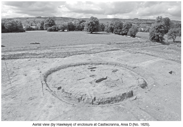
Area D
This was the largest of the excavated areas and covered 5528.5m2. The site was dominated by a subcircular enclosure with internal and external features.
The enclosure was defined by a ditch, on average 2.5m wide and 1.5m deep, filled with redeposited natural, natural silting, slippage (bank material?) and stone deposits (remains of a wall?). The ditch was steep-sided and the base was flat. Some post-holes or animal burrows were cut through the lower fills and into the base along the inner side of the north-east portion of the ditch. The ditch was respected by discontinuous narrow internal and external gullies or possible beam slots that were 0.2m wide and 0.12m deep. A small number of finds were retrieved from the ditch, including some chert (possibly struck), bone and a few unclassified metal objects.
The ditch enclosed an internal area of c. 27m by 24m. Access to the interior was gained from the south-east through a 2.5m entrance gap. A number of cut features located at the entrance may have formed a porch. These features include a short gully/slot, post- and stake-holes.
Internal features included a trapezoidal structure, gullies/slots, several pits, post- and stake-holes. The trapezoidal structure was located in the western half of the interior of the enclosure and was defined by shallow slots enclosing an area c. 3.5m by 2m. The structure contained a central post-hole and two stake-holes whilst possibly related external features include two post-holes and three short gullies or slots.
A sub-oval pit, measuring 5.5m by 1.8m and 0.95m deep, was located west of the trapezoidal structure. The pit fills comprised silty and sandy deposits with charcoal and animal teeth, bone and burnt-bone inclusions. It would appear that opposing stakes were driven horizontally into the sides of the pit at its south-west end. A vertical stake-hole was noted at the base directly beneath one of these stake-holes. The north-east end of the pit had two opposing vertical post-holes located at the point where the base and sides met. Two shallow irregularly shaped pits were located south and south-west of this pit.
In the space between these features and the gully/slot, which respects the north inner edge of the ditch, were two more pits. One of these pits had an irregular curving shape, measured 3.5m by 1.5m and was 0.2m deep with a charcoal-rich and burnt-bone-flecked fill. The base of this pit showed evidence of in situ burning.
To the north-west was another sub-oval pit, measuring 1.9m by 1.4m and 0.6m deep. The fills were mostly sandy with some charcoal noted at lower levels. A regular shallow circular cut/depression with a charcoal-rich fill was noted at the base of this pit. This occurrence was interpreted as an earlier phase of activity within this pit or the remains of an earlier feature. A cluster of features including small pits (one of which contained a small amount of slag), post- and stake-holes were located south of this pit.
A large sub-oval pit, measuring c. 6m by 3m and 1.15–1.3m deep, was located close to a short section of gully/slot respecting the north-west inner edge of the enclosure ditch. The fills of this pit were silty, sandy, silty clay, clayey sand and clay deposits with some charcoal inclusions. Two rounded stones (possible hammer/grinding stones) were retrieved from the upper pit’s fills. This feature was cut by a small curving gully or slot with stake-holes cut into its base. The gully was in turn partially truncated by a D-shaped pit.
A number of post-holes excavated in the south-west area of the enclosure interior may represent a small building. Apart from these post-holes and a short section of interior gully/slot respecting the inner edge of the ditch, the south and south-west part of the interior was free of features.
Features outside the enclosure include a possible structure or working area comprising closely situated stake-holes, post-holes and pit(s) located outside the enclosure and to the north of it. There was also an irregularly shaped pit located east of the enclosure. A number of other, less significant, features were scattered throughout the site. These included stone-lined drains which crossed the area south-west of the enclosure, one of which partially truncated the exterior edge of the ditch, and a series of undated furrows crossing the area east and north-east of the enclosure.
A number of interesting finds were encountered during surface cleaning of the site and subsequent metal detecting of spoil. A total of 156 finds have been recorded to date, most of which are metal. The list presently includes eight coins – a King John silver coin (early 13th century), three Elizabeth I silver shillings (1560–1), a possible Spanish silver ‘piece of eight’ (1572–1778), a Charles I silver coin (pre-1649), a Victorian sixpence (1878) and a corroded coin (with possible harp depiction)—seven metal buttons, six musket balls, numerous metal objects including bars, pins, possible hooks, nails and pieces which may derive from side-arms, eleven stone items including possible flint and chert lithics and two possible grinding stones, a possible bead/disc button, bone (burnt and unburnt bone, animal teeth), five pottery sherds (glazed and unglazed, nothing that appears prehistoric) and a small amount of slag.
An initial examination of the musket balls was undertaken by Damian Shiels (Headland Archaeology Ltd), who suggests that they are of mid- to late 17th-century date, probably associated with the Eleven Years War (1641–52) or the War of the Two Kings (1688–91). It would appear that the assemblage consists of both fired and unfired material, indicating the locality was the scene of either an engagement during the above-mentioned conflicts or was used as a training area for troops. Further analysis is required to confirm what weapons may have been utilised at Castlecranna. If other, as yet unidentified, objects from the site are confirmed as being military in nature, it would indicate the site is an important discovery for the archaeological identification and interpretation of small-scale conflict sites from this period in Ireland (D. Shiels, pers. comm.).
The coins, dating to the medieval and post-medieval periods, coupled with the occurrence of possible gun parts, musket balls and good-quality buttons, lends credence to the suggestion that nearby Cranna House was the site of the castle that is indicated by the townland name. It could be that the subcircular ditch is associated with the castle and may even be a precursor to it. Unfortunately only a handful of unidentifiable metal finds (probably nails and from late deposits) came from the ditch fills or other features. The coins, musket balls, etc., simply reflect the passage of people through the townland over a number of centuries and general Plantation activity in the area.
Further discussion of this site is not possible at present as post-excavation work is ongoing and specialist analysis has yet to be carried out.