2007:1588 - BALLYWILLIAM, Tipperary
County: Tipperary
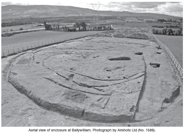
Site name: BALLYWILLIAM
Sites and Monuments Record No.: N/A
Licence number: E002479
Author: Kate Taylor, Margaret McNamara and Edel Ruttle, TVAS (Ireland) Ltd.
Author/Organisation Address: Ahish, Ballinruan, Crusheen, Co. Clare
Site type: Enclosure, House - prehistoric, Fulacht fia and Pit
Period/Dating: Prehistoric (12700 BC-AD 400)
ITM: E 579425m, N 674339m
Latitude, Longitude (decimal degrees): 52.819635, -8.305247
This site was excavated in advance of the N7 Nenagh to Limerick road project at Chainage 22660–23450. Ten separate areas (A–J) were investigated over an 800m-long stretch of the road-take on the east-facing lower slopes of the Arra Mountains, overlooking the Kilmastulla Valley. Areas A and H were adjacent to each other, Area C was amalgamated into Area F and Areas B, G, I and J did not contain convincing archaeological features. Areas A–E were excavated between 14 September and 15 December 2006, while Areas F–J were excavated between 2 February and 28 April 2007.
Areas A and H
Nine pits, ten post-holes and nine stake-holes were excavated in these co-joining areas at the northern end of the site. No obvious pattern was visible; however, the area had been badly disturbed by the laying of a carpark and by root activity and although the features did not appear to represent a structure there may have been one present originally.
The pits were generally oval in plan, 0.8–2.58m long and 0.18–0.6m deep. One of the pits showed evidence of in situ burning and others had small amounts of charcoal incorporated into their fills. In a disturbed corner of the largest feature was a small deposit of charcoal and cremated bone; however, as this has not been identified to species it is not possible to determine if this represents funerary activity.
The post-holes were generally circular in plan with vertical sides and flat bases. The more substantial examples were 0.2–0.36m deep. The stake-holes were small and not obviously related to the other features.
The only artefact recovered from the area was a possible grinding stone. The activity is therefore at this time undated.
Area D
This trench contained an irregularly shaped burnt-stone spread and associated features located on flattish ground which gradually rose to meet the plateau on which the Area F enclosure was located. In total, twenty cuts and 54 deposits were recorded. The cuts consisted of slots through the burnt-stone spread, four pits, ten stake-holes and slots through five linear features.
The burnt-stone spread was badly disturbed by modern drainage activity and also seemed to have been flattened. It was therefore difficult to determine the sequence of burnt-spread activity. The spread contained a variety of deposits, including in situ and disturbed burnt-stone deposits, charcoal-rich clay and sand deposits, redeposited sand, heat-affected natural, redeposited natural, ancient topsoil and peaty deposits. The burnt-stone deposits were composed of moderately compact black (dark-grey hue) silty clay containing heat-affected stone and charcoal.
One of the peaty deposits contained three fragmented and possibly worked timbers that were 0.8–1.4m long and 0.2m wide. This deposit overlay burnt-stone material at the north-east edge of the spread. These timbers may represent the remains of displaced trough/platform timbers.
A trough-like pit was located beneath the burnt-stone spread at its northern edge. This pit filled naturally with water. In antiquity the burnt-stone deposit slipped into the trough forming its primary fill. This fill was in turn partially sealed by a clay deposit. No lining was evident in this trough nor were any post- or stake-holes detected. The trough was subcircular in plan, bowl-shaped in profile, measured 1.31m by 1.16m and was 0.46m deep.
Two irregularly shaped pits were located near to the trough. One of these features measured 1.24m by 0.9m and was 0.35m deep while the other measured 2m by 1.8m and was 0.35m deep. One of the pits contained several clayey fills with wood and stone inclusions, the other sandy fills that produced two pieces of possibly worked stone, overlain by clay and peat.
A second possible trough was located 3m west of the edge of the burnt spread. This pit was very different to the main trough and may therefore have fulfilled a different function. It had a subrectangular shape with a shallow profile and generally flat base. The pit measured 1.11m by 0.8m and was 0.12m deep. The theory that this feature operated as a trough is supported by the fact that the pit filled naturally with water. The pit was filled with waterlogged soft light-grey silty clay with frequent stone content and occasional charcoal inclusions and was surrounded on three sides by eight stake-holes. One of the stake-holes cut the southern edge of the pit. These stake-holes may have supported a spit-like arrangement, canopy or windbreak.
Area E
Area E contained a fulacht fiadh, five deposits associated with the fulacht fiadh and five pits. The area was bounded to the north-east by a stream and an old streambed was revealed in the excavation. All the features where heavily truncated by agricultural activity.
The fulacht fiadh was horseshoe-shaped in plan, 14m long and formed a shallow mound. Three deposits made up the main body of the fulacht. The primary deposit was black sandy clay with burnt sandstone pieces and an oxidised deposit overlay this. The main deposit was dark-brownish-black sandy silty clay with >65% burnt stone and charcoal present throughout. A similar shallow deposit lay to the east of the main mound.
A trough pit was located roughly at the mid-point of the arc of the horseshoe shape and was facing the water source. The trough pit was subrectangular in plan, measured 1m by 0.73m and was 0.2m deep with a flat base The trough contained two fills: the primary fill was a brown organic deposit found only in the north-west side of the base of the cut, whilst the main fill was compacted brown to black sandy silt containing >50% small to large angular burnt sandstone pieces and some charcoal. The presence of the organic deposit might suggest an attempt at lining the trough. There was a lot of root activity to the west of the trough and burnt-stone material accumulated here butting the trough cut.
Two other pits were excavated in relation to the fulacht fiadh. One pit, wholly under the main burnt-stone deposit, was oval in plan, measured 2m by 0.8m and was 0.3m deep. Another pit was just partially under the burnt stone. This elongated pit was flat-based, measured 3.3m by 1.1m and was 0.27m deep.
West of the fulacht fiadh lay a deposit of greyish-black silt with a small amount of burnt sandstone and charcoal. Two pits were exposed after this deposit was sectioned. The two pits were subcircular and measured 0.7m by 0.6m and 0.12m deep and 1.5m by 0.6m and 0.26m deep.
Areas F and C
This area was the largest and contained the most significant remains, a large ditched enclosure with internal features, a round house and several pits containing prehistoric pottery.
The enclosure was located on the edge of a plateau with the land dropping away to the east and south. The southern side of the enclosure was truncated, probably as a result of erosion of the natural sand deposits on the sloping hillside, and furrows were seen across the entire site, the result of modern ploughing. Almost the entire enclosure lay within the road-take, with just the extreme north-western edge extending into the adjacent field. It is recommended that the remainder of the enclosure outside the CPO be entered into the RMP for County Tipperary.
The enclosure was somewhat D-shaped with a straight edge on the south side; it measured 49m across internally and had a south-east-facing entrance that was 4m wide. The ditch was 1–2.5m wide and 0.36–0.99m deep with a U-shaped profile.
Within the enclosure were at least three partial gullies, possibly indicating internal palisades, only surviving on the better-preserved northern side of the monument. At the enclosure entrance one of these features deepened to form a trench that contained packing stones at either end, presumably marking the location of large entrance posts, perhaps indicating a gate in the palisade.
Internal features included a 5.7m-long stone-lined corn-drying kiln, the ephemeral remains of a circular building with a diameter of c. 6–7m and a very large pit (6m by 2.75m and 1.42m deep), the function of which is unknown, although it did contain a number of quern fragments within its sterile sandy fills. Numerous smaller pits with charcoal-rich fills indicate domestic or industrial activity, and several substantial post-holes and short lengths of gully may represent other structures.
Between the enclosure ditch and the nearest palisade gully, on the north side, were eleven parallel elongated pits, typically measuring 2m by 0.45m. These features may possibly have been graves; however, due to the acidic nature of the soil, no bone survived. Two pits containing cremated bone may also be burials, although the bone has not yet been identified to species. One of these pits truncated the internal edge of the enclosure ditch and also produced a fragment of lignite bracelet, whilst the other contained a number of corroded iron objects.
To the north of the enclosure were a round house and several pits, some of which contained substantial amounts of prehistoric pottery of a variety of types, over 100 sherds in total.
The round house was defined by a penannular gully with an internal diameter of 6.5m and a 0.8m-wide south-east-facing entrance. Post-holes were located at either side of the doorway and a number of internal post- and stake-holes were recorded. The structure was badly plough truncated and cut by a large pit on the southern side.