2007:1587 - BALLYNAHINCH, Tipperary
County: Tipperary
Site name: BALLYNAHINCH
Sites and Monuments Record No.: N/A
Licence number: E002552
Author: Kate Taylor, TVAS (Ireland) Ltd.
Author/Organisation Address: Ahish, Ballinruan, Crusheen, Co. Clare
Site type: Flat cemetery, House - prehistoric, Fulacht fia, Burnt spread, Enclosure and Field system
Period/Dating: Multi-period
ITM: E 573256m, N 667841m
Latitude, Longitude (decimal degrees): 52.760958, -8.396231
This site was excavated in advance of the N7 Nenagh to Limerick road project at Chainage 13520–14100. Excavations were carried out between 16 October 2006 and 30 January 2007. Seven separate areas were excavated along a 580m length of the road route. The site was located on the slopes of a south-facing hillside and in the base of a valley, between the villages of Birdhill and Ballinahinch. To the east the land rises steeply into the foothills of the Silvermines Mountains and to the north-west a small rocky outcrop overlooks the excavation areas. The southern four areas were in low-lying marshy ground through which a steep-sided stream flowed.
Area A
This was the largest area, encompassing over 1.8ha. The site sloped down from 107m OD at the north to 100m OD at the south. Excavated features covered a range of types and periods.
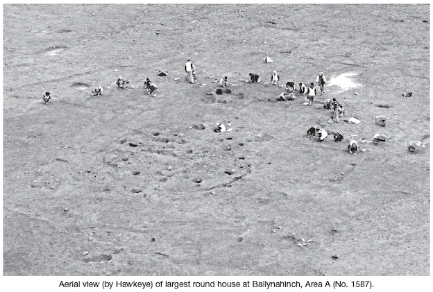
At least five round houses were investigated. One of these buildings produced prehistoric pottery and it is likely that the different structures are all of a similar date. The most substantial house was formed by a penannular gully with an internal diameter of 9.4m and a south-east-facing entrance. Inside the ring gully were four pits, 23 post-holes and at least 800 stake-holes. The post-holes form a circuit, presumably representing roof supports. Some of the pits were located immediately inside the ring gully; i.e. against the wall of the house. As these features contained evidence of burning it is not clear how they were used without setting fire to the building. The stake-holes are difficult to interpret as their sheer number makes the identification of individual structures such as internal partitions or furniture almost impossible.
Although one of the other round houses had a partial ring gully, they were generally represented by circuits of post- and stake-holes. These buildings were smaller than the above example, with internal diameters of 1.8m, 2.4m, 4.2m and 4.6m and, where visible, south-east-facing entrances. In addition a small arrangement of post- and stake-holes, 7.2m across, may represent an animal pen.
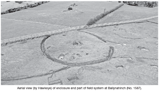
An undated ditched enclosure was excavated on the north-western edge of the area, close to the northern end, on a slight knoll. Almost the entire monument lay within the road-take. The enclosure was circular in plan with an internal diameter of 25m and a 3m-wide east-facing entrance. The enclosure ditch was 1.1–1.85m wide and 0.55–1.15m deep with a variously V-shaped and U-shaped profile. No evidence of a bank survived. There were few internal features associated with the enclosure, a small number of pits containing burnt material and a large pit with a number of incised stones. The enclosure may represent an early medieval ringfort, although prehistoric barrows are also known in the immediate locality.
Two small parallel ditches formed a droveway 5m wide and over 150m long that snaked across the site, joining the edge of the enclosure for part of its route. Other ditches appear to be related and may form part of a large field system contemporary with or later than the enclosure.
The northern part of the site contained evidence of post-medieval occupation and agricultural activity in the form of a cobbled surface and a number of ditches that formed a rectangular field system. At least four small paddocks or haggards (on average 20m by 15m) were recognised, in addition to larger fields. Some of these post-medieval ditches respected the enclosure, suggesting that it had some aboveground expression into at least the 19th century, although it is not indicated on the first-edition OS map, surveyed in 1840.
A large number of other features such as pits and post-holes and at least one cremation burial were excavated across the site. The pits included a concentration in the vicinity of the southernmost round house. These pits had diameters of 1.8–2.4m and were typically 0.2m deep with charcoal-rich fills; two also contained large stones at the base, perhaps suggesting an industrial function. These features presumably relate to the various phases of activity described here.
Area B
This area was located on flat ground at the base of the hill, immediately adjacent to the road. The underlying geology was clay with stones and the site flooded frequently, demonstrating that the pits were naturally fairly watertight.
A fulacht fiadh was composed of a mound made up of fourteen burnt-stone deposits, a large trough with twelve stake-holes, a post-hole and five other pits. The low mound was amorphous in plan, measured c. 16m by 14m and was up to 0.35m thick with the trough a little off-centre. The deposits were dark-brown or black silty clays with high charcoal content and up to 40% burnt-stone fragments. There was no evidence of a hearth.
The subrectangular trough measured 2.4m by 1.8m and was 0.42m deep with steep sides and a flat base. The twelve stake-holes did not form a clear pattern but were clustered at either end of the trough, whilst the post-hole was located on the edge of the pit at the west. The trough was filled by several of the burnt-stone deposits that also formed the mound. The five other pits beneath the mound varied in size and shape.
Fifteen pits were excavated elsewhere in the area. These features were typically oval in plan, were 0.9–2.25m long and 0.12–0.44m deep with various profiles, some with vertical side and flat bases, others more concave or irregular. Two stake-holes were recorded in the side of the largest pit. Ten of these pits contained burnt-stone and charcoal-rich fills, whilst a further two contained deposits of stones. No artefacts were recovered.
Area C
A small cremation cemetery containing seven burials and three other pits was excavated in a 975m2 area on flat ground at the base of the hill, south-east of the fulacht fiadh in Area B. The site was very badly disturbed and most of the features were almost completely truncated. The burial pits, as they survived, were subcircular in plan, 0.13–0.8m wide, 0.04–0.2m deep, and had steep sides and flat bases. The main pit fills were black charcoal-rich deposits containing large fragments and small flecks of cremated bone. The two best-preserved examples showed evidence of a sealing layer of redeposited natural overlying the burnt material and it is possible that all the burials originally had similar stratigraphy. No finds other than cremated bone were recovered from the pits.
Area D
This area was immediately adjacent to a stream and was severely flooded during excavation. A small spread of black burnt-stone material, that measured 11.3m by 7.2m within the road-take, continued into the adjacent field to the south-east. The deposit was up to 0.5m thick and was truncated in part by a ditch, presumably an agricultural field drain. No cut features such as troughs were discovered in the excavated portion of the site.
Area E
A small fulacht fiadh consisted of an oval spread of burnt-stone material and a trough. The amorphous spread of loose black sandy silt with burnt sandstone measured 12m by 8.8m and was up to 0.65m thick, filling a natural hollow and also covering and filling the trough. The unlined trough was oval in plan, measured 3m by 2.55m and was 0.4m deep with steep edges on three sides and a more gradual sloping edge on the fourth. A nearby oval pit measuring 1.8m by 1m and 0.3m deep with steep sides and a concave base contained burnt-stone material similar to the spread.
Area F
The features in this area proved to be non-archaeological.
Area G
A large fulacht fiadh-type monument was excavated on the south-east bank of the stream that flowed in a deep channel through the southern end of the site. The stream appeared to have been mechanically deepened, possibly to prevent flooding of the properties that backed on to it. The mechanical work has probably truncated some of the archaeological deposits outside the excavated area.
Three deposits of burnt-stone material covered an area 35m by 10m and filled a hollow at the stream edge that was up to 1.2m deep. The hollow was probably originally a natural feature but may have been deliberately enhanced, as some of the edges were fairly steep.
At the base of the hollow, beneath the burnt-stone deposits, was a small subrectangular trench perhaps 2m by 1m and up to 0.7m deep that contained four stone slabs set on edge in a 1.7m long line along one side. It is possible that this was the original trough and that further stones were removed in antiquity.
A single small pit with a burnt-stone fill was located some distance from the main activity.
The burnt-stone spread was cut by large field ditches, thought to be post-medieval in date. In addition, a line of large stones cut into the top of the deposit probably represent a collapsed field wall. A further ditch was also investigated on the eastern side of the site. It is recommended that those portions of the site outside the CPO be entered into the RMP for County Tipperary.