2007:1568 - ANNAHOLTY, Tipperary
County: Tipperary
Site name: ANNAHOLTY
Sites and Monuments Record No.: N/A
Licence number: E003530
Author: Kate Taylor, TVAS (Ireland) Ltd.
Author/Organisation Address: Ahish, Ballinruan, Crusheen, Co. Clare
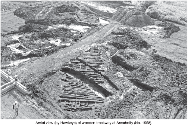
Site type: Road - class 1 togher
Period/Dating: Iron Age (800 BC-AD 339)
ITM: E 568342m, N 663577m
Latitude, Longitude (decimal degrees): 52.722369, -8.468622
This site was excavated in advance of the N7 Nenagh to Limerick road project at Chainage 6810. Excavations were carried out between 25 June and 9 August 2007. A wooden trackway was discovered during monitoring of excavation works within Annaholty Bog (E3462, see No. 1558, Excavations 2007). The bog covers a large area straddling the Limerick–Tipperary border between Castleconnell village and the Silvermines Mountains.
The trackway had been truncated by a bog road, a machine-cut drain and by some of the groundworks for the road construction but survived in the sections between the truncations. The timbers were located 0.4–0.8m below the modern bog surface, and the level of preservation varied along the length of the track, depending on depth.
The trackway ran south-west to north-east between two gravel islands within the bog, essentially connecting two areas of dry ground. The largest of these is Toreheen island, at which a bronze spearhead (1947:228) was found in the 1940s. The bog at Annaholty has itself produced a number of archaeological objects from unknown findspots including a leather shoe and stone spearheads. Unfortunately neither end of the trackway was revealed, both having been destroyed by construction work. It is possible, however, to estimate that the trackway would have been 65–70m long in order to reach dry ground at both ends. The surviving portion was 55m long (with sections missing within this length).
At 7m wide this was a particularly large example of a timber trackway. The method of construction was the same as that of the renowned Iron Age trackway at Corlea, Co. Longford: two lines of roundwood runners were laid along the length of the track and large planks were laid side by side on top, held in place by pegs. Towards the centre of the site, halfway between the dry islands, the underlying peat was wetter and softer. In this area several layers of roughly parallel timbers underlay the main planks and patches of brushwood were also used as a foundation layer.
Immediately beneath the trackway at the north-eastern end of the surviving portion was a perpendicular arrangement of irregularly laid timbers, largely roundwoods. It is not clear if these timbers related to an earlier structure or if they were part of the trackway widening where it met dry ground.
At the south-western end four patches of timber were found beneath the trackway. These features were clearly not related to the main site as they were up to 0.5m below the planks, sealed in peat. The patches may represent small platforms or parts of earlier trackways.
A total of 1112 pieces of wood were recorded and lifted from the site. Of these, over 350 were obviously worked. The worked pieces included some of the planks that had mortice holes at the ends for the pegs, the pegs that had finely sharpened points, numerous cut branches and logs and a number of wooden artefacts. The artefacts included several vessel fragments, a barrel-stave and a number of larger items that have not yet been identified but may be part of a cart or some piece of agricultural equipment.
It is anticipated that dendrochronological dates will be obtained; however, at the present time the trackway is undated. It is thought, however, based on initial observations (C. Moore, pers. comm.), that some of the toolmarks on the stakes indicated use of iron woodworking tools, providing a terminus post quem for the site. It is possible, however, that some of the underlying wooden features could be of an earlier prehistoric date.
It is likely that the narrow crossing point between Toreheen island and the adjacent gravel mound would have been a focus of activity throughout the prehistoric and historic periods, and indeed the presence of the modern bog road that crossed the site demonstrates the importance of these natural routeways.
To ascertain more data about the bog and its relationship with archaeological sites in the area, a programme of palaeoenvironmental coring will take place in Annaholty in 2008–9.