2007:1268 - BOYERSTOWN (1), Meath
County: Meath
Site name: BOYERSTOWN (1)
Sites and Monuments Record No.: N/A
Licence number: A008/013
Author: Kevin Martin, Archaeological Consultancy Services Ltd.
Author/Organisation Address: 21 Boyne Business Park, Greenhills, Drogheda
Site type: House - medieval, Field boundary and Pit
Period/Dating: Medieval (AD 400-AD 1600)
ITM: E 683514m, N 765822m
Latitude, Longitude (decimal degrees): 53.635531, -6.737194
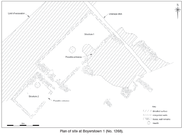
This site was located within Contract 3 (Navan bypass) of the proposed M3 Clonee to North of Kells motorway, was identified during testing by Nigel Fairburn in 2004 (Excavations 2004, No. 1190, 04E0580) and was excavated between May 2006 and April 2007. The archaeological remains on the site extended over an area measuring 300m by 50m. The remains of two drystone-built adjacent structures, constructed directly on the natural surface, and associated wall remains which were previously demolished and levelled were uncovered and excavated. The houses are likely to have been contemporary. Their remains survived to a wall height of up to two courses, c. 0.5m. House 1 measured 13m by 5.5m; House 2 measured 6m by 4.5m. Owing to the numbers of iron nails of varying sizes found within and in proximity to the structures, it has been suggested that the buildings may have had wooden upper storeys, or were part wooden construction. No internal partitions were evident during excavation although the possibility of the use of wooden partitions should be noted. Each structure had a hearth area located towards its centre. Numerous sherds of medieval pottery and metal artefacts including iron nails, copper-alloy pins and a decorated ring brooch were recovered in this area during the excavation, indicating a date of approximately 12th–14th century for occupation of this part of the site.
The area around the structures was characterised by a series of interconnecting metalled surfaces which abutted the stone walls. These were in places cut with linear drains in order to drain water away from around the area of the houses. The fragmented remains of a human skull were found in a well-cut pit nearby to the house area.
The south-eastern and eastern area of the site contained a significant amount of mostly parallel linear furrow features and occasional pit features. The furrows were hand-cut, single-filled and contained medieval pottery. They were evenly spaced and provide evidence for the practice of ridge and furrow activity on the site. A large, deep well/pit was located in this area. This pit is likely to have been the main water collection point for the occupants of the site and occasionally functioned as a dumping pit for domestic refuse.
The structural and metalled area remains were bounded by two large east–west-running ditches which extended the full width of the land-take. A number of smaller drainage ditches were cut into the surrounding area. Most of the linear features excavated, including the large ditches, contained medieval pottery and so were likely to be contemporary with the structural elements of the site.
Beyond the area of the east–west drainage ditches towards the north-east the site extended and was characterised by further metalled areas, ditches, pits, and drains. The remains of an extended, articulated, supine burial were found in the base of a large ditch in this area. Stratified pottery found in the ditch suggests a medieval date for this burial.
The artefact count from the excavation at Boyerstown 1 was approximately 10,200. This number is mostly made up of medieval pottery, mostly Leinster wares, and also includes imported wares. Other artefacts include fragmented quernstones and medieval coins. Given the quantity and quality of the pottery assemblage and the fact that a number of the metal finds included fine jewellery pieces (brooches, rings, belt-buckles, and pins), this would indicate that the previous occupiers of the site were quite wealthy and of high status. The site was most likely occupied for approximately 200 years before being abandoned.