2007:1265 - RATH MAEVE, BELPERE and ODDER, Meath
County: Meath
Site name: RATH MAEVE, BELPERE and ODDER
Sites and Monuments Record No.: ME037–008
Licence number: C228; E3465
Author: Finola O’Carroll and Mandy Stephens, CRDS Ltd.
Author/Organisation Address: Greenanstown, Stamullan, Co. Meath
Site type: Henge
Period/Dating: Prehistoric (12700 BC-AD 400)
ITM: E 692134m, N 758308m
Latitude, Longitude (decimal degrees): 53.566577, -6.609111
A programme of survey, field-walking, investigation and restoration was carried out on behalf of the National Monuments Service, DoEHLG, in July and August 2007 at Rath Maeve (ME037–008; ME031–033). Rath Maeve is a national monument in private ownership, part of which is subject to a guardianship order. The monument is located in the townlands of Belpere and Odder in the Barony of Skreen, Co. Meath. It is one of a group of Late Neolithic/Early Bronze Age embanked enclosures in the Boyne region. These enclosures or henges tend to occur in clusters and in association with passage tombs (Stout 1991, 245). The site is located at the southern end of the Hill of Tara and is a component of the Tara complex.
The monument was constructed around a hill at the south end of the ridge. The size of its flat-topped earthen bank is accentuated by the topography (Stout 1991, 257). Even in its current denuded state, the bank is impressive and estimated to measure up to 10m wide and 5m high (Newman 1997). It was constructed by means of scarping up to 25m of the interior from the base of the bank to provide construction material.
A visit was carried out by Mandy Stephens on behalf of the Minister on 3 May 2007, in order to halt agricultural clearance works being carried out in contravention of Section 12 (3) of the National Monuments Act 1994. A subsequent assessment of the damage was undertaken by Tom Condit of the National Monuments Service and also by CRDS Ltd. The monument has suffered disturbance and damage since at least 1910, when the second edition of the 6-inch OS map of the area was published. The most recent damage consisted of further removal of the monument’s bank in the southern sector and damage caused by the passage of machinery through a gap in the south-east quadrant of the monument, which allows access to the adjoining field.
The project subsequently undertaken at Rath Maeve consisted of a programme of survey, field-walking, limited investigation and recording, followed by limited repairs to the recently damaged sections of the monument’s enclosing bank. The investigative works were carried out between 20 and 29 August 2007 by a team of three archaeologists, one supervisor and one director. All excavation was carried out by hand.
Investigation
Excavation and investigation was limited to a small portion of the bank, but a significant amount of information was recovered. A stepped section and a sondage were cut into the damaged face of the gap in the bank (termed Gap 9) on the south-east of the monument. Plans and profiles were recorded at intervals along the recently damaged portion of the bank, a stretch of about 75m. No excavation was attempted in this area and recording was limited to exposed deposits.
Gap 9 appears on the second-edition OS map; the entrance gap ran downslope from the interior to the exterior, from 141.38m OD to 140.01m OD. The difference in height is slight in this area in comparison to the western and northern parts of the monument. A stepped section was cut into the damaged face of the south-facing section of the bank. The upper section (section D-D1) measured 5.8m in length and 0.6m in height. The lower section (C-C1) measured 5.4m by 0.4m. Due to the slope of the ground, the lower section was continued west by means of a staggered sondage which measured 14m by 0.75m and ran north-west/south-east along the base of the bank from the interior of the monument downslope through the gap.
The purpose of the excavation was threefold: to determine the full depth and nature of the bank deposits; to determine the natural slope of the ground; to identify whether the bank was constructed with material scarped from the interior of the monument or with upcast from an internal or external ditch
A total of 47 features were identified and these were numbered consecutively from 1 to 47. Features identified were primarily deposits forming the bank, a scarp cut, slump deposits associated with the bank, at least two modern drains and a number of modern agricultural furrows. Written, drawn and photographic records were made of all features and a selection of the bank deposits was sampled. Only two finds were recovered, both pieces of struck chert.
Stout’s hypothesis (1991, 246–8) on the scarping of the interior of the monument in order to derive material for the bank construction has been confirmed. Stone revetments F5 and F6 were used to stabilise the bank and a series of stone slump deposits, F29 and F32, suggest the bank may have been faced. Tip lines identified in the sondage suggest that derived material was redeposited to form the base layers of the bank by ‘tipping’ it downslope sequentially. The formation of these strata became increasingly horizontal as construction continued upwards, suggesting that material was tipped to form a level foundation for the upper layers. Interior revetment F5 was laid on a ‘pad’ which appeared raised by reason of the scarping on its west side. The exterior revetment F6 did not appear to reach original ground level. A stake-hole, F43, may represent a peg for setting out the bank or demarcating the scarp and bank.
A layer of sandy clay, F30, with a high stone content, which directly overlay scarp cut F47, may belong to the construction phase of the monument rather than the later stages of slump and slippage. As this was a compacted layer it is possible that it was deliberately laid as a ramp over the face of the scarp, which would otherwise have been quite slippery underfoot.
At some point post-construction, the bank began to ‘slump’ down over its internal footing and revetting material F5. The slump lines were visible in primary and secondary ‘wedges’ of material, suggesting two major phases of slippage. The primary slump material, composed of two layers of small to medium angular stones, F29 and F32, suggests the bank may have been faced with stone. The later phase of slippage would appear to have been a more gradual process of slump and accumulation.
Assessment of the damaged bank between Gap 8 and Gap 9 suggests the damage is much more extensive than previously thought. A stone deposit which ran much of the length of the damaged section is likely in some places to represent the external revetment and not the rubble core as initially suspected. This represents the almost complete destruction of the southern bank of Rath Maeve. Investigation of the bank between Gaps 8 and 9 was limited to recording the exposed deposits only; further excavation was not attempted.
Field-walking
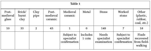
Field-walking took place on 20 and 21 June 2007, in the field south of and adjacent to Rath Maeve. A temporary grid was set up dividing the field into 10m-wide lanes east–west and north–south. Setting out of the temporary grid was undertaken to analyse locational density of recovered objects. The retrieval strategy required collecting all objects to avoid bias in the record. A total of 269 objects were recorded. Analysis of these is pending completion of the field-walking phase of the project, which will happen when the interior of the monument is ploughed. Objects are listed by type and category in Table 1.
A total of 156 pieces of stone were collected and of these only seven showed any evidence of being worked. The worked stone includes two potential scrapers and five pieces which may have been struck, and are possible cores or debitage. Specialist advice will be sought on these pieces. The majority of the diagnostic collected objects were post-medieval. A single sherd of medieval ceramic was collected. Of the metal objects, only one is of interest, a copper-alloy coin of uncertain date. The field-walking provided few objects which could be associated with the monument. However, this is consistent with other field-walking studies adjacent to similar monument types (G. Cooney, pers. comm.) and suggests space adjacent to these monuments was possibly excluded from general use. The study has added a small number of artefacts to the total of one for the townland of Belpere, listed in the NMI topographical files.
Field-walking in the interior of the monument is to take place after ploughing and harrowing to return the field to usable pasture after its use as a potato field. This has not yet happened, so this phase of the field-walking programme has been deferred until that work is done.
Survey
The monument was surveyed using a combination of GPS and total station to record the condition of Rath Maeve prior to restoration and post-restoration, to provide a record of the remedial works. The survey will complement work previously carried out by the Discovery Programme. Comparative analysis of the two surveys should provide information on any increase in recent years in damage to the banks or alteration to the interior levels of the site.
References
Newman, C. 1997 Tara: an archaeological survey. Dublin.
Stout, G. 1991 Embanked enclosures of the Boyne region. In RIA Proceedings, xci, C, 245–84.