2007:970 - KILKENNY: Rothe House Garden, Rothe House, Parliament Street, Kilkenny
County: Kilkenny
Site name: KILKENNY: Rothe House Garden, Rothe House, Parliament Street
Sites and Monuments Record No.: KK019–026
Licence number: 05E0598 ext.
Author: Cóilín Ó Drisceoil, Kilkenny Archaeology
Author/Organisation Address: Unit 11, Abbey Business Centre, Abbey Street, Kilkenny
Site type: Designed landscape - formal garden
Period/Dating: Medieval (AD 400-AD 1600)
ITM: E 650359m, N 656173m
Latitude, Longitude (decimal degrees): 52.654412, -7.255689
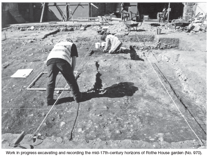
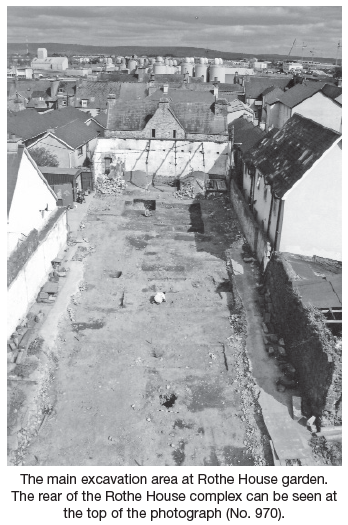
Excavation was carried out in February–May and August 2007 within the garden of the historic Rothe House, Parliament Street, Kilkenny. Rothe House is positioned in the historic core of the walled medieval town of Kilkenny and is a national monument and protected structure within the Kilkenny city area of archaeological potential.
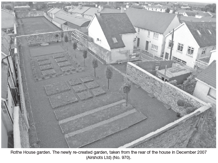
The site has a rich history spanning some 800 years and today is Ireland’s best-preserved example of an urban mansion of the Irish Renaissance period (c. 1560–1650). Since 1962 it has been the subject of ongoing restoration and conservation works by the Kilkenny Archaeological Society and in 2002 a conservation plan for the historic property was completed. A key objective of the plan was to re-create the original gardens within the burgage plot to the rear of the house. The project was funded primarily by Fáilte Ireland. Central to the re-creation process was the archaeological excavation that took place within the garden site.
To ascertain the horizontal and vertical extent of archaeological stratigraphy that survived within the site and to inform the research design for the project, seven test-pits were excavated across the site in July 2005 (Excavations 2005, No. 821). This determined that archaeological soils endured in two separate locations in the east and west ends of the plot, with the intervening area having been scarped to subsoil when the garden was modified as a working yard 1968–74. It was also determined that sections of the foundations of the southern garden walls survived in the west end of the plot.
Ian Elliot of Irish Geophysical and Archaeological Surveys undertook earth resistance and magnetometry surveys within the site in February 2007, following the removal of modern overburdens. This survey indicated that substantial disturbance had occurred throughout the plot, though at the eastern end square anomalies, reminiscent of ‘planting beds’, were identified. Further anomalies indicated pitting and linear features.
Fifteen archaeological cuttings were opened within the site, a total area of 380m2 or 23% of the garden.
The medieval garden c. 1210–1541
The earliest archaeological evidence encountered was typical of Kilkenny’s medieval burgage plots, being in the form of refuse pits and remnant horticultural soils. There was also evidence for a burgage fence that preceded the Rothe plot, the Rothes having subsumed two narrower plots to form their 15m-wide (3-perch) garden. In addition, an 8m deep stone-lined well was dated by associated ceramics to the 13th–14th centuries. This phase of activity relates to when the site was occupied by a townhouse for the Cistercian abbot of Duiske Abbey, Graiguenamanagh.
The Rothe garden 1541–1654
Following the Dissolution of the Monasteries the Cistercians lost their townhouse and it passed to the Rothe family, who in the early 1590s began construction of an elaborate Renaissance-style mansion with gardens to its rear. The only surviving contemporary allusions relating to how these gardens appeared are to be found in the will of John Rothe (1619) and the Civil Survey (1650). It is possible from the two documents to determine that the burgage plot was occupied by a large orchard within which were a dovecote and a summerhouse. The orchard backed on to the town wall and was divided from a lower garden and yard that extended from the rear of the house complex.
The best-preserved section of the Rothe family garden was found sealed beneath an 18th-century gardening horizon in the part of the plot nearest the house. No archaeological material could be identified for the half-century after the Rothes gained possession of the property in 1541. Instead, the earliest phase of activity was represented by the excavation and subsequent backfilling between c. 1590 and 1601 of two large quarry pits in the east of the site. The pits may be related to the extensive construction activities that were occurring within the house complex at this time.
The construction of the stone burgage walls, the importation of soils and the laying out and use of a garden is attributed to the period c. 1601–1654. The beginning of this phase is based on associated coin evidence; the end relates to the date when the Rothes lost possession of the property. The construction of the stone walls and an internal cross-wall that divided the orchard and kitchen garden is assigned to this phase of activity. At this time a kitchen garden (‘potager’) was also laid out over the backfilled quarry pits. Within this it was possible to distinguish a series of square and rectangular sunken planting beds, tree pits and a series of grassed paths. Coins dating to 1601 were recovered from an associated sod layer, providing a terminus post quem for its construction. Remnant deposits from the orchard were also recorded near the town wall.
This archaeological evidence provided important new information regarding the framework and arrangement of the garden. It suggests that the Rothes utilised elements of both the formal English-style ‘Renaissance’ gardening they would have been familiar with from places such as Bristol—it was partially a pleasure garden with a summerhouse and formal orchard. On the other hand they also retained elements of the earlier local medieval gardens—it was walled and not integrated as a single design with the house. Such a garden very much reflected the ‘Old English’ outlook of the Rothes.
In March 1654 the Order of Confiscation was issued to clear the city of the ‘Old English’ families who had been marked men as a result of their support for the Confederate government. At this moment the Rothes lost everything and they were forced out of their house and out of the city. There is some slight evidence they may have returned to the property following the Restoration in 1660 but they never regained the power and influence they had had in earlier years. By the early 18th century the house was in the possession of the Butler Ormondes and this dynasty held it until 1811.
The 18th–20th-century gardens
The archaeology of the post-Rothe garden site is extremely complex. During this time the garden appears to have remained relatively intact, apart from at its west end, where extensive quarry-pits were dug in the early to mid-18th century. In the east of the site, nearest the house, a new garden of completely different design to that of the Rothes was laid out in the early to mid-18th century. This new garden sealed the earlier Rothe one beneath it and comprised a series of long north–south rectangular planting beds that were divided by narrow grass paths. In the late 18th century the town wall at the west end of the plot was demolished and replaced with a flimsier stone wall construction on the same line.
In the late 19th century the garden was broken up into four separate units and at roughly the same time an arcaded coach house was constructed against the former town wall. Concurrently, sections of the stone garden walls were renewed in the west and north-east of the site.
Before 1946 a slaughterhouse was constructed against the eastern dividing wall with the house complex and in the early 1950s the west of the site was transformed into a timber yard and the former coach house buildings were modified accordingly. The remainder of the site appears to have continued in use as a vegetable garden and orchard until the late 1960s when the Office of Public Works began construction for a works depot.
The finds
Over 2000 finds were discovered during the excavation. Most of these items may have originated within the homestead but later found their way into the garden when the house midden heap was spread out as fertiliser. Ceramics formed the bulk of the assemblage and included a range of exotic items that underlined the status of the family as wealthy merchants: Westerwald, Frechen, Seville olive jars, fine tin-glazed earthenwares. Sherds of German table glass were also recovered. A large number of hairpins, a bodkin, shoe buckles and coins that were found in the planting beds were probably lost by the servants as they tended the vegetables and herbs. A rare find was the handle of an ‘apostle spoon’ that would probably have been given to one of the Rothe children when they were christened.
Plant remains
Especially important for the project was the analysis of ancient plant remains. At the time of writing the analysis of charred seeds and charcoals is under way. The analysis of pollen from the Rothe-period planting beds resulted in the identification of a wide variety of plant species including oak, alder, birch, hazel, cabbage, chicory, plantains and Apiaceae flowers. There is, however, some difficulty in extricating from the site’s botanical record the evidence that relates directly to the plants that were growing within the Rothe garden.
Animal bone
Eleven animal species were identified in the assemblage of 2089 bones. These included cow, sheep/goat, goat, pig, dog, horse, red deer, cat, rabbit, rat and mouse. The identification of fish and animal bone is being undertaken at the time of writing.
Conclusion
This was the first time the garden archaeology of an early townhouse had been comprehensively investigated in Ireland. The results of the excavation proved to be of critical importance for understanding the evolution and topographical development of the site and they formed the basis for the re-creation project that was officially opened by President Mary McAleese in April 2008.