2007:967 - KILKENNY: Talbot’s Tower, Ormond Road, Kilkenny
County: Kilkenny
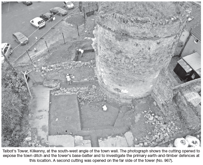
Site name: KILKENNY: Talbot’s Tower, Ormond Road
Sites and Monuments Record No.: KK019–026
Licence number: E3646; C240
Author: Cóilín Ó Drisceoil, Kilkenny Archaeology
Author/Organisation Address: Unit 11, Abbey Business Centre, Abbey Street, Kilkenny
Site type: Town defences
Period/Dating: Multi-period
ITM: E 650439m, N 655653m
Latitude, Longitude (decimal degrees): 52.649732, -7.254586
During October–December 2007 excavation was carried out at the medieval town wall at Talbot’s Tower, Ormond Street/New Street, Kilkenny. Talbot’s Tower guards the south-west angle of the city’s Hightown fortifications. The excavation was a research exercise which formed part of a programme of conservation measures for the walls that are being guided and developed by the Kilkenny City Walls Steering Committee and funded by the Irish Walled Towns Network Fund and Kilkenny Borough Council. The excavations occurred in tandem with an archaeological building study undertaken by Ben Murtagh.
The excavation at Talbot’s Tower provided important new evidence regarding the topography and development of the town wall at this location and clarified the sequence and chronology of the fortification’s construction. The key discovery, however, was the confirmation of the existence on the site of the earliest Anglo-Norman earth-and-timber defences. Such a survival is quite uncommon and their archaeological excavation a rare event.
Fortuitously preserved beneath the earthen embankment were the remains of the pre-Anglo-Norman ground level, the earliest activity encountered during the excavation. Before the bank was raised the sod had been stripped from this layer, leaving behind the underlying ‘B-horizon’.
The primary defences were probably constructed c. 1200 and comprised a ditch, the excavated material from which was piled in a structured manner on the town side to form a bank c. 1.6m high by 4.5m wide. This was probably topped with a timber palisade and the corner where Talbot’s Tower now stands defended with a wooden brattice.
In the latter half of the 13th century the replacement in stone of the earth-and-timber fortifications commenced. The base-batter and footings for a stone corner tower were inserted into the embankment and the bastion raised. At the same time the inner edge of the town ditch was revetted in stone and the curtain wall erected. Extensive sections of the town wall were thus defended. The town ditch at this time was 1.3m deep, flat-bottomed and probably c. 5m wide. Later activity had altered and possibly widened its outer edge, making reconstruction of its original width impossible. The town ditch of the southern defences may have been considerably wider, perhaps c. 7m.
There appears to have been a slight time lag between the completion of the tower and the curtain wall, as evidenced by the development of a sod level which overlay the turret’s footings but on to which the curtain wall was built. The recovery of Kilkenny-type pottery from this layer provides a terminus post quem of c. 1250 for the wall’s construction. No direct dating evidence was obtained for the tower’s construction.
No medieval stratigraphy survived within the town ditch, as a consequence of their scouring presumably in an attempt to refortify the fosse. This probably occurred in the run-up to the Williamite wars. Following this the town ditch was rapidly backfilled with the massive dumping of redeposited ‘topsoil’, probably sourced during the construction of ‘New Street’ to the west. Ceramics and a 1683 coin from its primary fills suggest this occurred in the late 17th/early 18th century. By mid-century the ditch was completely filled in and it is shown as such on Rocque’s 1758 map.
Extensive reorganisation of the area occurred in the early to mid-19th century with the construction of Ormonde Road and the National Model School. The area outside of Talbot’s Tower became the rear of a formal garden for the ‘Rose Cottage’ on New Street and landscaping works for the Model School led to the lowering of the ground level and the modifications to the curtain wall. Probably at the same time, large borrow pits were dug into the backfilled town ditch to extract the facing stones of the ditch revetment and to rob-out substantial sections of the curtain wall on either side of the tower.
The Kilkenny City Walls steering group will use the results of the excavation to inform the presentation of the town and its environs to the general public.