2006:2194 - WICKLOW: Wicklow Port Access Town Relief Road, Wicklow
County: Wicklow
Site name: WICKLOW: Wicklow Port Access Town Relief Road
Sites and Monuments Record No.: N/A
Licence number: 06E0091
Author: Edmond O’Donovan, Margaret Gowen & Co. Ltd.
Author/Organisation Address: 27 Merrion Square, Dublin 2
Site type: Fulacht fia, Hut site, Church, Graveyard, Field system, Habitation site and Brickworks
Period/Dating: Multi-period
ITM: E 731222m, N 694127m
Latitude, Longitude (decimal degrees): 52.981804, -6.045831
Test excavation and subsequent full excavations were carried out along the route of the Wicklow Port access town relief road. A total of 12,984 linear metres of test-trenches were excavated, with a centreline trench excavated along the axis of the road and offset trenches located at 10m intervals. During the test excavation, 39 new sites of archaeological potential were identified. Of these, three principal sites were discovered: a Bronze Age cooking place or fulacht fiadh associated with a hut site; an early medieval church and graveyard associated with a medieval field system and settlement activity; and an 18th-century brick-manufacturing site. In addition, a series of field drains and isolated pits filled with charcoal and burnt stone were located throughout the scheme.
Bollarney South, 18th-century brick-manufacturing or ‘brickfield’ site
Deposits of ash, brick and burnt clay were uncovered over a large area overlooking the Murrough, north of Wicklow town. The features excavated on the site provided evidence of red-brick production in the area. The present-day Brickfield Lane, located on Church Hill, originally led to the site; Church Lane is separated form the site by the railway, which was built in the late 19th century.
The extraction of suitable clay is a primary step in the production of bricks. A large pit was found at the western end of the site. This pit had a diameter of 10m and an approximate depth of 1.6m and was cut through a thick mid-brown clay. It is probable that the clay from this pit was moulded and fired on site.
The largest feature on the site was a rectilinear feature filled with crushed red brick and rubble. It was orientated north-east/south-west and measured 33m long, 6.8m wide and 0.55m deep. A rectangular spread of charcoal was located 4.5m to the east. It measured 19m north-east/south-west by 5m. The deposits were 0.2m deep. This was probably the result of burning associated with brick manufacturing on site. There were a series of later plough furrows cutting through the surface of this feature.
A sunken red-brick surface was excavated in the centre of the site. This was the only evidence of a structure on site. It consisted of a simple rectangular pit measuring 3.7m by 2.7m cut 0.7m into the ground surface, baselined in red brick. It is suggested that the sunken surface was an area where clay and temper were mixed with water to manufacture the basic unfired clay prior to it being placed in moulds before firing.
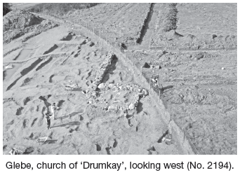
Glebe, early medieval and later church and graveyard, medieval settlement and occupation (in the vicinity of WI025–011)
A significant excavation was undertaken in Glebe townland under Knockrobbin Hill. A previously unlocated church and cemetery site was discovered adjacent to the Rathnew/Wicklow town road. A total of 191 burials were uncovered, enclosed within a series of ditches. The burials date from the early medieval period (c. AD 600) and appear to continue in an unbroken sequence up to at least AD 1600. The foundations of a stone church were also recorded during the excavations. It is suggested that the discovery is the church site of ‘Drumkay’. Previous documentary and cartographic evidence suggested that the site was located c. 400m to the north-east.
The church, Phase I
The foundations of a substantial stone church were uncovered in the centre of the site. The primary church building measured 14.65m east–west by 7.3m externally. The walls were between 1 and 1.3m wide with an interior space of 12.35m east–west by 5.18m.
The southern wall of the church was orientated east–west (280°W, 100°E). It was c. 15m in length, with the south-west corner located beyond the limit of excavation. It survived to a maximum height of 0.85m. The wall was constructed with roughly hewn limestone blocks, light to mid-grey in colour. The size of the stones varied considerably, with the largest measuring 0.69m by 0.34m by 0.12m and the smallest 0.22m by 0.12m by 0.04m. It appeared to be constructed of random coursing. This wall turned north at the east end and continued for c. 3.7m, where it was removed by later phases of activity.
The church, Phase II
The east wall of the church was clearly removed at some point. A new east wall was constructed 1.6m to the west. Thus the remodelled church (Phase II) was shorter than the original building. The Phase II structure measured 12.05m east–west by 7.3m externally. The walls were once again between 1 and 1.3m wide with an interior space of 9.35m east–west by 5.18m.
The new east wall was 5.1m long. It is probable that this wall abutted the northern wall of the church, which was visible in test-trenches located outside the road-take. The wall survived to a width of 1m at its south end and widened to 1.5m to the north. It was constructed of very mixed masonry. Four large granite boulders formed the core of the wall. Three of these were of a similar size and measured c. 0.74m by 0.61m by 0.51m, while the fourth was approximately half that size. The rest of the masonry consisted of a mix of limestone and shale. There was no evidence of mortar, but clay had been packed between the stones as a bonding. There was no obvious coursing. There was some evidence of facing on the east side, but this was not substantial. The wall survived to a maximum height of 0.58m, with some sections as low as 0.13m.
The church, Phase III
A walled annexe or ancillary building was added to the eastern end of the church. The annexe measured 4.2m east–west by 5.5m externally, with internal dimensions of 3.5m east–west by 4m.
The east wall of the annexe building (F841) was 4m to the east of the Phase II church and parallel to the earlier east wall. The annexe wall was built from rubble. It was clearly later than the Phase I and Phase II building, as the base of its foundation was higher than the bases of the other walls; it was also stratigraphically above the east end of the Phase I church wall. It measured 5m long and survived to a width varying between 0.2 and 0.51m. It was of mixed rubble construction, which included limestone, granite, sandstone and a small amount of mudstone. A number of burials were interred over this wall, including Burial XXX, which was directly over it. The wall was robbed-out in places, with a gap where a later burial cut through it. A large sandstone boulder (0.55m by 0.59m by 0.29m) at the north end of F841 marked the corner between it (F841) and the north wall (F776) of the annexe.
The north wall ran east–west. It survived only to a height of one to two courses and was constructed of smaller stones than the rest of the walls associated with the church, with a mixture of sandstone, limestone and mudstone. The stones varied from 0.15m by 0.08m by 0.08m, to 0.36m by 0.26m by 0.06m. This may suggest that it was associated with a separate phase of construction, probably contemporary with F841. F776 survived to a total length of 3.75m (including the sandstone boulder linking F776 with F841). It measured 0.47m in width at the western end, widening to 0.61m at the point where it turned to join the east wall (F841).
Ditches and boundaries
The church was surrounded by three enclosure ditches and a fourth post-medieval field boundary. The earliest of these was also the innermost ditch, which was located at the brow of the hill. It was excavated to a length of 26.5m and continued under the western baulk of the site. The terminal of the ditch was quite ephemeral and appeared to slope gradually upwards to the east. This ditch had a maximum depth of 0.75m and contained two fills. The lower fill was a mid-brown silty clay, with moderate inclusions of small stones (c. 0.05m in diameter) and a maximum depth of 0.34m. The upper fill was mid-orangey-brown silty/sandy clay with similar inclusions to the lower fill. This fill had a depth of 0.24m. There were no finds from this ditch.
It was cut on its southern side by the second ditch. This was recorded over a 19m length, with a maximum depth of 0.6m and width of 2m. No definitive terminus was identified and it gradually petered out to the east. The basal fill consisted of a mid-orangey-brown sandy clay. The secondary fill consisted of a brown silty clay. A stone perforated pendant was found within this fill. The upper fill of the ditch was a mid-brown silty clay with some sand and occasional mottling of yellow clay.
The second ditch was in turn cut by a later ditch located immediately outside it. The third ditch had an excavated length of 32m, with a maximum depth of 0.9m and a maximum width of 2.4m. It had a maximum of six fills, with only three visible in some sections. The lowest fill was a clayey silt that was very similar to the surrounding natural. It is probable that this was a natural silting of the ditch. The remaining fills consisted of a clayey silty sand and silt.
The three enclosure ditches followed the same course on the site, along a break of slope roughly parallel to the wall of the church. A fourth ditch of post-medieval date cut across the earlier enclosures at a different angle. It appears that the later post-medieval ditch followed the line of the earlier enclosing elements of the site and removed evidence for them as it continued north-east and north.
The enclosure ditches mirror the orientation of the church walls marking the limit of the burial-ground. The burials were mainly contained within the line of the two inner ditches. Three burials (Burials I, LXXV and LXIV) were within the upper fill of the two innermost ditches. This supports the interpretation that the ditches were not contemporary and were realigned as the cemetery expanded. The overall dimensions of the enclosing ditches, including the extents uncovered within the test-trenches, surround a site c. 33m north–south by 47m.
Burials
A total of 191 burials were excavated on the Glebe site. This number includes truncated burials, where later activity (often burial) removed part of the earlier burial, and burials where some or all of the bone has degraded. In cases where bone has completely decayed, evidence for the presence of a burial was recorded through the observation of a visible grave-cut into the boulder clay. Fifteen infants, 48 juveniles and 120 adults were excavated on the site. There were eight empty grave-cuts, where the skeletons had disintegrated completely. Additional burials are likely to have been interred at the site where neither the bone nor grave-cut has survived.
The predominant burial rite was extended inhumation in the supine position, while a small number had flexed limbs. The majority of the burials were orientated east–west, with the skull to the west, indicating a Christian tradition. They were tightly clustered within and outside the walls of the church. The burials varied in date, with some pre-dating the church, such as the lintel grave (Burial CLX) which ran under the southern wall of the church. Burials XC and LXXXIII ran under the north–south wall of the church and were therefore earlier than the church structure. Burials such as CXXXIV and LVI were more accurately orientated in line with the church than others, such as Burial LIX. This would suggest that some individuals were buried in a period where the orientation of the church was less influential, perhaps pre-dating the church, or from a period after it fell out of use. Other burials, such as Burial XXX, which lay directly over the stones of the north–south wall, clearly post-date the building.
A series of later medieval ditches and a house site were also uncovered 100m to the east. It is clear that the ditches were field enclosures dating from c. AD 1200–1500, although some of the features represented pits and other settlement activity.
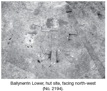
Ballynerrin Lower, fulacht fiadh and hut site
The fulacht fiadh consisted of a spread of burnt stone and charcoal measuring 9m in diameter. The fulacht fiadh mound was composed of a mixture of sandstone and a local shale. A rectangular trough was identified under the northern side of the burnt mound and was partially covered by the burnt-stone deposits. The trough measured 1.95m by 1.5m and was 0.32m deep. There was some evidence for a wooden plank lining at the base and sides, which survived as charcoal staining in the soil. Four large stake-holes were cut into the base of the trough, one in each corner. These appeared to have functioned as posts retaining a plank lining of the feature. The average dimension of the stake-holes was 0.2m in diameter and 0.2m in depth. A large pit was located 0.1m to the west of the trough. It measured 3.25m by 2m, with a depth of 1.2m. It quickly filled up with water during excavation and was interpreted as a water source for the trough.
A layer of grey ashy silt (F10) was identified beneath the mound. This was interpreted as a sod layer altered by the heat of the fulacht fiadh. The ash deposits measured 11m east–west by 9m, with a depth of 0.15m. A group of stake-holes were cut into F10, but no discernible pattern was identified. The stake-holes varied in dimensions from 50mm by 50mm by 50mm to 120mm by 80mm by 150mm and contained a charcoal-rich fill. The stake-holes were not visible on the surface of the mound, due to the similarity of the soil types, but were clearly cut through the fulacht fiadh in section.
A U-shaped hut structure was identified to the south of the fulacht fiadh. It survived as a foundation trench, with a double-row of stake-holes cut into the base of the trench. A number of finds came from this feature, including a flint scraper and a quartz hammerstone. The internal dimensions of the hut were 1.4m by 2m. The foundation trench consisted of four separate interlocking features/depressions (F37, F35, F4 and F46). The northernmost feature (F37) measured 1.6m east–west by 0.8m and was 0.23m deep. F35, to the west, measured 1.1m by 0.73m with a depth of 0.15m. The pit to the east (F4) measured 1.88m by 0.76m with a depth of 0.25m. There were a series of stake-holes cut into the base of the foundation trenches, suggesting that there may have been a wattle woven wall surrounding the hut.