2006:2150 - MACREDDIN BROOK GOLF CLUB: Ballycreen Lower/Cronawinnia/Macreddin East/Macreddin West/Sheenabeg (Robeck)/Sheenabeg (Whaley), Wicklow
County: Wicklow
Site name: MACREDDIN BROOK GOLF CLUB: Ballycreen Lower/Cronawinnia/Macreddin East/Macreddin West/Sheenabeg (Robeck)/Sheenabeg (Whaley)
Sites and Monuments Record No.: WI034–010 and WI034–009
Licence number: 05E0846
Author: Emer Dennehy, for Margaret Gowen & Co. Ltd.
Author/Organisation Address: 27 Merrion Square, Dublin 2
Site type: Charcoal-making site and Kiln
Period/Dating: Multi-period
ITM: E 712411m, N 682379m
Latitude, Longitude (decimal degrees): 52.880542, -6.329880
Monitoring of all ground-disturbance activities associated with the construction of Macreddin Brook golf club was undertaken between September 2005 and June 2006. The golf-course encompasses a 95.02ha site surrounding the Brooklodge Hotel, Aughrim, Co. Wicklow, and is divided in two by Ballycreen Brook. It surrounds two RMP sites—WI034–010, the site of the military village of Carrysfort, and WI034–009, Macreddin graveyard. No aboveground remains of Carrysfort village survive, but the graveyard is still in use today, defined by an earthen field boundary in the east and a breezeblock wall in the north, south and west. A large granite baptismal font/stone basin is also present within the graveyard and this has been incorporated into a makeshift altar, presumably used for the celebration of pattern masses and funeral services. A geophysical survey of ‘Castle Field’ was undertaken and several anomalies were identified. This field is believed to mark the location of Carysfort Castle and was excluded from the development.
Three features of archaeological interest were identified upslope and to the north of Ballycreen Brook, in the townland of Macreddin. These features consist of a kiln and two charcoal-production pits.
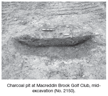
Pit I (NGR 12977 82480; OD 11.2m) is the largest of the three pits and appears to have been used in the production of charcoal. The cut was oval in plan with a concave profile and measured 1.7m east–west by 1.08m with a maximum depth of 0.28m. The sides and base of the cut were heavily oxidised by burning. This pit contained six fills, which provide evidence for at least two episodes of burning. This pit produced a two-sigma radiocarbon date of AD 782–971, placing the activity in this area into the late stages of the early medieval period.
Pit II (NGR 12869 81745; OD 10m) is also interpreted as a pit used for the production of charcoal and was situated 30m to the north-east of Pit I. The cut was subcircular in plan with a concave profile, measuring 1.2m east–west by 1.28m and 0.22m in depth (maximum). As with Pit I, the base and sides of the cut were highly oxidised due to in situ burning, with particular concentrations of burning occurring in the eastern half of the pit. Pit II contained three fills, the most distinctive of which was the charcoal lining. This lining was present across the base and the east, south and west walls of the pit cut to a maximum depth of 0.08m.
The kiln feature was located downslope and to the west of Pit II. It was a severely truncated keyhole-shaped kiln and comprised an oval ‘fire bowl’ with a small linear ‘flue’ present in the north-west. The fire bowl had a concave profile and measured 1.4m north-west/south-east by 0.9m by 0.12m in depth (maximum). It contained three fills, with the primary fill comprising a 0.02m layer of burnt clay, possibly representing a clay lining used to seal and insulate the fire bowl. This then was overlain with a 0.06m lining of charcoal present on the base and sides of the fire bowl. The uppermost fill was a mixed layer of brown silt and embers and was also present within the flue. The flue measured 0.56m in length by 0.3m by 0.06m in depth and was separated from the pit by a setting of limestones.
No other features or stratigraphy of an archaeological nature were identified.