County: Tipperary Site name: CLOUGHJORDAN: Oxpark and Townfields
Sites and Monuments Record No.: N/A Licence number: 06E0257
Author: Emer Dennehy, Margaret Gowen & Co. Ltd.
Site type: Fulachta fia and Sweathouse
Period/Dating: Undetermined
ITM: E 597244m, N 689160m
Latitude, Longitude (decimal degrees): 52.953222, -8.041004
The proposed development at Cloughjordan comprises a 67-acre site within which a ‘sustainable village’ is to be constructed. A total of 133 mixed residential units will be constructed on the southern twenty acres of the site and 30% of the development site will be used for woodlands with the remaining 40% used for agricultural activity. The site is in a rich archaeological and historical environment, with the three RMP sites located within or adjacent to the development. These sites, namely the moated site (TN011–028) and Cloughjordan Castle (TN016–001), attest the Anglo-Norman occupation of the area. The enclosure site, though levelled, is illustrated on cartographic sources and was perceived to be medieval in date. However, a late Bronze Age/Early Iron Age ring-barrow was identified immediately adjacent to the enclosure and now suggests the enclosure could be prehistoric.
Initial investigations involved a detailed geophysical survey (06R020) and this was followed by an archaeological impact assessment targeting known and suspected areas of archaeological activity. A total of 2184 linear metres of trenches were opened, identifying five archaeological sites that would be impacted upon by the development. The area of the enclosure was excluded from the testing programme. The five sites identified were two fulachta fiadh (Sites 1 and 2), 1 burnt spread (Site 3), a post-medieval blast furnace (possible) (Site 4) and a ring-barrow (Site 5). Sites 4 and 5 were excluded from the development and are to be preserved in situ. Sites 1–3 were excavated over a four-week period in June/July 2006.
Site 1
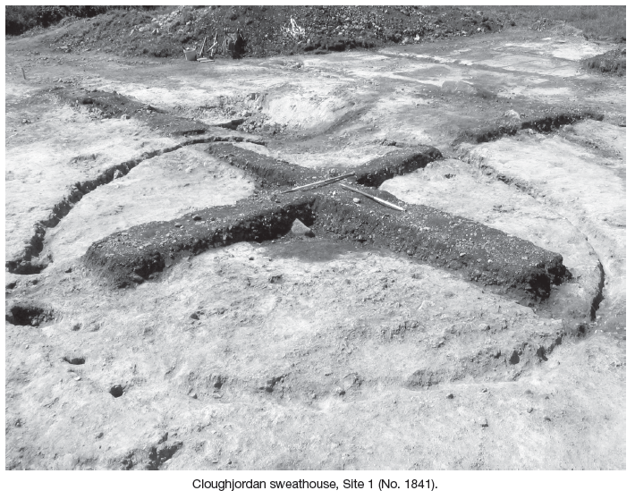
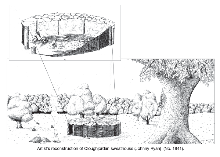
Located 10m to the south of a small stream, this site presented itself as a circular mound of fire-cracked limestones in a charcoal matrix measuring 19.5m north–south by 16.7m. Upon excavation it was established that the mound was extremely shallow, surviving to a maximum depth of just 0.2m. It was composed of multiple burnt limestone and sandstone deposits concentrated in the north and east of the site. It overlay a large subrectangular trough and the remains of a circular hut site. The stratigraphy of the site indicates that the trough and hut site were contemporary and that the site functioned as a sweathouse. The site was extremely well organised; hearths were located at a distance of 3m to the south of the hut, stockpiles were located to the east, while debris was mounded in the north and west.
The hut was subcircular in plan with internal measurements of 6.5m north–south by 5.5m (7m by 6m externally). It had two entrances, one in the south-east the other in the south-west, each defined by a pair of large post-holes. No internal roof supports were identified, indicating that the hut did not have a permanent roof structure but rather one constructed from woven matting and/or hides. The trough was located in the south-west of the hut 1m from the entranceway. It was subrectangular in plan (2.8m north–south by 1.8m by 0.81m); the base was lined with an oak plank. Three phases of use for the hut site were identified; it appears to have been deliberately dismantled on cessation of use.
Site 2
This was a large fulacht fiadh located 160m to the north-west of Site 1. It comprised a large subcircular mound of burnt limestones measuring 26m north–south by 20m and was sited on a small rise. Due to the wet location of the site, seasonal or periodic abandonment of work was noted through episodes of peat regrowth within the mound. The integrity of the site stratigraphy was compromised by land reclamation activities and further disturbance caused by the burial of a horse. The use of the site focused around its centre, where the troughs and roasting pits were identified in association with a small windbreak, effectively creating a distinctive work area measuring 10m north–south by 6m. The hearths within which the stones were heated were confined to the west of the site; stockpiles of limestone were gathered to the east, while debris mounds primarily accumulated to the north and east of the troughs. In this instance this information indicates that the site originally had a horse-shoe-shaped layout where activities focused to the north, east and west of the troughs, while the southern side of the site was left open to accommodate access to/from the work area. Two troughs and four roasting pits were excavated; not all the cut features were contemporary. Only one trough provided evidence of a wood lining.
Site 3
This site comprised a thin spread of burnt-mound material situated 80m to the south-west of Site 1. This spread survived to a maximum depth of 0.03m and measured 6m north-west/south-east by 7m. It was composed of 50% heat-shattered limestone in a charcoal-enriched dark-brown peat matrix.
Analysis of the soil samples are pending, as are three radiocarbon determinations from Sites 1 and 2.


27 Merrion Square, Dublin 2