2006:1812 - BALLYLEGAN, Tipperary
County: Tipperary
Site name: BALLYLEGAN
Sites and Monuments Record No.: N/A
Licence number: A035/00, E2265
Author: Melanie McQuade, Margaret Gowen & Co. Ltd.
Author/Organisation Address: 27 Merrion Square, Dublin 2
Site type: Enclosure, Structure and Quarry
Period/Dating: Multi-period
ITM: E 608043m, N 625895m
Latitude, Longitude (decimal degrees): 52.384544, -7.881843
Four sites (Sites 207.1–3 and Site 206.4) were excavated in advance of construction on the N24 slip road linking to the N8 north of Cahir.
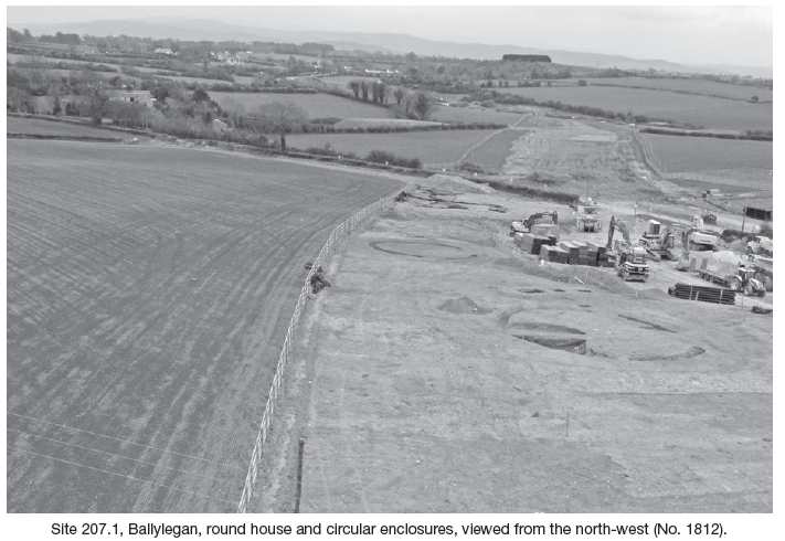
Site 207.1 was located on elevated ground, with good views of the surrounding area. The area of excavation measured 95m by 45m. Within were two circular enclosures, the foundation remains of a subrectangular structure and a round house. The larger of the enclosures, F4, had a diameter of 17.15m. It was enclosed by a ditch which measured 1.3m wide and 0.5m deep. The other circular enclosure, F107, was 22m east of F4. It was slightly smaller, with a diameter of 12.5m. The ditch was 1.2m wide and a maximum of 0.4m deep. It had an opening at the south-west. The enclosure ditches were cut by field ditches dating from the post-medieval period and a quarry had been dug into the northern end of the larger enclosure.
The remains of a subrectangular structure were located 10m north-west of the circular enclosure F4. It was defined by five pits and a post-hole, which formed a subrectangular floor plan with an internal area of 9m by 10.5m. An Early Bronze Age date of 2137–1945 cal BC was obtained for one of the pits.
The round house was 33.5m to the north-west of the enclosure F4 and 18m west of the subrectangular structure. It was defined by a semicircular arrangement of slot-trenches and post-holes. It had a diameter of 6m and the entrance was at the south-west. There was a hearth and several pits within the structure. A Late Bronze Age date of 1047–893 cal BC was obtained for this structure.
Site 207.2 was down slope and 39m to the east of Site 207.1. The area of excavation measured 30m by 45m and there was evidence for three periods of settlement activity dating from the Middle Bronze Age through to the Late Iron Age/early medieval period.
The remains of a Middle Bronze Age (1686–1519 cal BC) structure were represented by a cluster of post-holes and a hearth on the southern end of the site. There were several other post-holes in the vicinity but these did not form a coherent ground plan. A second hearth and a series of associated pits were the remains of an unenclosed work area on the south-eastern end of the site.
A circular structure was located centrally on the site. It was constructed from a timber frame of posts set c. 0.6–0.8m apart. The building had a diameter of 8.5m and a south-east-facing entrance. The roof would have been supported by the walls and a series of internal posts. It was probably constructed of thatch, sod or some other organic material. There was no clear indication of internal divisions within this structure and it may have had an open floor plan. A large central heath and several associated stakes and pits suggest that the building may have had an industrial function. There was a large, rectangular pit in the north-eastern part of the structure. It was 1.2m by 1.14m and had a circular pit at either end. The pit was 0.6m deep with vertical sides and a flat base. Linear impressions along the sides and base of the pit indicate that it had once been wood-lined. There were frequent inclusions of charcoal, fire-heated sandstone and burnt bone within the fill of the pit, which may have functioned as a trough, used in conjunction with the nearby hearth. The trough was backfilled with refuse after it went out of use. Finds from the trough include sherds of a near complete coarseware pot and two fragments of a metalwork mould.
A third structure was represented by three lines of pits and post-holes and a central cluster of stake-holes at the north-eastern limit of excavation. The exact nature of this structure has not been determined since it is highly likely that further post-holes or other structural elements extend beyond the edges of excavation.
Another structure on the northern end of the site was defined by four linear slot-trenches, one of which extended beyond the northern limit of excavation. The trenches exposed within the excavation area indicate that the structure was subcircular in plan, with a diameter of 9.7m. However, there was no substantial evidence for southern or western walls and the walls at the south and west of the building could have been lighter constructions that required little by way of foundations and have subsequently disappeared from the archaeological record. Alternatively, it is possible that the structure was open ended, serving as a windbreak. Several post-holes around the perimeter of the structure may have held posts used for additional wall or roof support. A clearly defined hearth and a cluster of associated post-holes within the structure indicate that it was occupied or used as a sheltered work area. A Late Iron Age/early medieval date of 402–539 cal BC was obtained for this structure.
A deposit of silty sand with patches of burnt earth and charcoal sealed the central area of the site. A large number of artefacts including a spindle whorl fragment, struck flint, a possible scraper made from chert and sherds of prehistoric pottery were recovered from this deposit. These finds were not all dated to the same period and it is likely that the deposit resulted from cultivation of the land in the centuries succeeding the abandonment of the central structure.
Site 207.3 was located 45m to the south-west and downslope of Site 207.1. The area of excavation measured 15m by 20m and the site comprised two cooking pits. These pits were probably contemporary with the Bronze Age settlement on the nearby site.
Site 206.4 was 220m south of Site 207.2 and the area of excavation measured 40m by 21m. The site provided evidence for settlement activity dating from the Bronze Age. There were five post-holes and a cluster of stake-holes at the centre of the site, but these had no coherent ground plan. Nearby were a storage pit and a heavily truncated occupation deposit. Several other post-holes were scattered across the site but their layout did not form a coherent ground plan. An external hearth on the south end of the site returned an Iron Age date (192–4 cal BC) and it is likely that most of the features are contemporary with this.