County: Meath Site name: TRIM: Athboy Gate
Sites and Monuments Record No.: N/A Licence number: C150, E2398
Author: Matthew Seaver, CRDS Ltd.
Site type: Structure and Town defences
Period/Dating: Medieval (AD 400-AD 1600)
ITM: E 680101m, N 757357m
Latitude, Longitude (decimal degrees): 53.560009, -6.790952
Assessment and excavation were undertaken in the northern area of Haggard Street, known as the generalised location of the medieval Athboy Gate within the walled circuit of the town. The work was carried out as part of the Trim street reconstruction project in November 2006. The exact location of the gate and indeed the town wall at this location is unknown and they were last depicted on a map in 1747 (Hennessy 2004). This map, held by the Church Representative Body, indicates that the gate stood at the corner of the large rectory garden known as ‘Mr Seaton’s Garden’, now enclosing a housing estate, Priory Grove. It was referred to as the ‘Bl’aac’zhat’ in 1532, a corruption of Black gate, as it allowed access to the medieval Dominican friary (Potterton 2005, 183–4). It was to be repaired in 1682 and a drawbridge is mentioned in corporation records (Thomas 1993, 196). The gate was still standing in 1752 (ibid.). It may well have been standing in 1796 (Potterton 2005, 184). It has also been suggested that the gate may have been a suburban gate unconnected by a wall (ibid.). A cross on the second-edition OS 6-inch map in the centre of the junction of the Kells road, Athboy road and Kildalkey road indicates ‘Site of Athboy Gate’. Archaeological assessment of this junction was undertaken by Clare Mullins in 1999, which included test-trenches covering all aspects of this three-road junction (Excavations 1999, No. 717, 99E0142). This work found no traces of the gate or wall and largely found cobbled surfaces overlying natural boulder clay.
The 2006 programme of testing involved placing a north–south trench on the western side of the street between the junction of Loman Street/Haggard Street and the point at which Haggard Street splays into the Kells road, Athboy road and Kildalkey road. It measured 30m in length and was up to 2m in width.
The test-trench revealed that the tarmac was up to 0.1m in depth. It overlay deposits of roadfill up to 0.3m in depth overlying boulder clay.
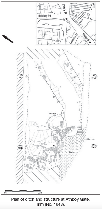
Immediately outside an entrance gate of the Porta Via take-away, extensive archaeological deposits were uncovered. An area measuring 11m north–south by 4.5m was excavated. This was partially under the concrete footpath and the road surface. Initially the archaeology consisted of a collapsed masonry structure cut on its eastern side by a recent concrete manhole, which was part of the water main constructed in 1999. A large ditch running parallel with Haggard Street was found to terminate at a masonry structure at the narrowest point of the road.
This masonry structure consisted of a curving unmortared stone footing. It had random coursing and was built from uncoursed masonry up to 1.2m in depth and 1m thick. It was placed within the terminal of a large ditch cut, F6. Limited excavation behind the wall demonstrated organic silty fills similar to those filling the ditch F6 (see below). It was tied in with the footing of an east–west stone wall, up to 1m in thickness. This survived to one course in height and was built from squared limestone blocks with a rubble core, F7. It clearly pre-dated the 18th-century boundary wall. This may be the base of the town wall, although it was not battered or mortared.
A substantial ditch 6m south-east/north-west by 4.6m in width and 1.6m in depth ran from this structure, F6. Its western edge was not uncovered and underlay the rectory garden wall. This ditch ran in line with the existing Haggard Street. The central and upper deposits within this ditch contained backfilled stony red/brown silty clay deposits, which were probably the remains of a substantial bank, 0.8m in depth. This was relatively sterile and contained many large unmortared stones. At 0.8m were a series of pungent green/grey sandy-silt deposits with orange flecks. These contained frequent animal bones, including a human skull fragment. It is possible that these are cess-based. The bank deposits overlay a deposit of organic clayey silt that filled the 2m-wide low-lying channel within the ditch. This deposit contained significant quantities of decayed plant remains, a number of sherds of 13th–14th-century pottery, an iron pitchfork and a deposit of textiles, possibly woollen cloth. Large quantities of animal bone, particularly cattle, were recovered from this deposit. The ditch subsequently continued under the rectory garden wall.
Any structural remains on the east side of the road are likely to have been destroyed by the digging of a water main, a sewer and telecom cabling. Subsequent monitoring of the roadway north, south and east of the excavation yielded boulder clay a short distance below the road surface. The remains uncovered during this assessment may be the only surviving evidence of the Athboy Gate. The ditch may have acted to funnel traffic approaching the gate. All masonry and the excavated ditch were preserved in situ.
References
Hennessey, M. 1995 Irish historic towns atlas, No. 14, Trim. Dublin.
Potterton, M. 2005 Medieval Trim: history and archaeology. Dublin.
Thomas, A. 1993 The walled towns of Ireland. Irish Academic Press, 196–9.

Unit 8, Dundrum Business Park, Dundrum, Dublin