County: Meath Site name: DUNBOYNE: River Tolka
Sites and Monuments Record No.: N/A Licence number: 05D026 ext., 06E0092
Author: Rex Bangerter, The Archaeological Diving Co. Ltd.
Site type: Bridge
Period/Dating: Modern (AD 1750-AD 2000)
ITM: E 701309m, N 742098m
Latitude, Longitude (decimal degrees): 53.419268, -6.475886
A detailed archaeological survey of Old Navan Road Bridge was undertaken in January 2006 prior to its proposed removal as part the River Tolka flood alleviation scheme. Systematic recording of the structure was carried out using a total station EDM, supplemented by photographic and hand-drawn elements, to produce a series of detailed bridge elevations and plans that constituted a comprehensive record of the existing bridge structure. In addition, a bridge removal strategy was formulated to maximise the retrieval of archaeological information during the removal process, which was undertaken at a later date under licence number 06E0092.
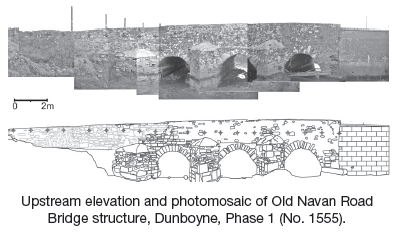
Three bridge-build phases were identified as part of the survey. The upstream side (Phase 1) of the bridge was largely of 18th-century date, whereas the downstream section (Phase 3) represented a 19th-century bridge-widening endeavour. Comparison of build quality and construction technique suggests that the internal bridge section (Phase 2) was also of 19th-century date, comparable to that of Phase 3. In addition, the upstream cutwaters are considered to be modifications added when the bridge was widened on its downstream side, probably contemporary with Phase 3.
A number of artefacts were recovered from the current phase of recording work and included three L-shaped wrought-iron spikes associated with build Phase 1, a lead plumb weight, a bowl fragment from a silver spoon (18th-century in form); a George VI ‘one penny’ piece (1937); and a commemorative medal thought to honour the centenary of the Catholic Emancipation of 1829.
Old Navan Road Bridge was removed under archaeological supervision in August 2006, to allow continued recording of the bridge and the three construction phases that encompass the structure as a whole. The removal process was initiated on the downstream side and the bridge structure was deconstructed in chronological fashion: removing build Phase 3, followed by Phase 2 and lastly Phase 1. This allowed detailed recording of the interface between each of the build phases. Two bridge elevations were generated, showing the bridge façade of bridge Phase 2 and the original, downstream, façade of bridge Phase 1. A series of datum points were fixed to each phase of bridge structure to allow a photo-mosaic elevation of each bridge façade to be made. In addition, the upstream (Phase 1) and downstream (Phase 3) arch-rings were surveyed to provide a detailed drawn elevation of the arch faces (Arch-rings 1–3 upstream and Arch-rings 1–3 downstream). These arch-stones were individually labelled for retention following the bridge’s removal. An elevation of Cutwater number 2 was also included to illustrate the differing build phases located within the cutwater structures.
The Phase 1 bridge foundations were left intact until the upper elements of the bridge structure had been recorded and removed. This facilitated comprehensive inspection of the original bridge piers/footings. Two test-trenches were machine excavated along the north and south side of Pier 3, allowing the interface between the riverbed and pier structure to be examined. Subsequent to the removal of the four pier structures, a 2m by 6m test-trench was excavated across the riverbed; no subsurface archaeological remains were present beneath the bridge structure.

Brehon House, Castlecomer, Co. Kilkenny