2006:1092 - SCART (AR022), Kilkenny
County: Kilkenny
Site name: SCART (AR022)
Sites and Monuments Record No.: KK040-088 and KK040-089
Licence number: A032/AR022, E3001
Author: Jonathan Monteith, for Valerie J. Keeley Ltd.
Author/Organisation Address: Brehon House, Kilkenny Road, Castlecomer, Co. Kilkenny
Site type: Timber circle and Structure
Period/Dating: Neolithic (4000BC-2501 BC)
ITM: E 656766m, N 622634m
Latitude, Longitude (decimal degrees): 52.352358, -7.166732
This site was identified in the townland of Scart, Co. Kilkenny, in the course of work carried out for Kilkenny County Council/National Roads Authority during the N9/N10 Waterford to Powerstown scheme. Excavations were carried out between July and September 2006 and between November 2006 and January 2007.
This site, which covered an area of c. 3500m2, was located on an elevated plateau, gently sloping to the south-east, east of the River Blackwater valley, with extensive views towards Tory Hill to the east, as well as views to the west and south. Six main areas of activity were identified during excavation.
Area A
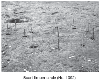
Area A, in the central part of the site, revealed a circular arrangement of eleven post-holes, including a possible entrance porch to the south-east. The post-holes were on average 2m apart with a central post-hole and possible hearth. The outer diameter of this probable structure was 8m, enclosing an area of c. 50m2. The post-holes varied in dimensions, with an average diameter of c. 0.44m and maximum depth of around 0.55m. The central post was slightly smaller, with a 0.3m diameter and depth of 0.38m. An area of oxidised clay at the centre of the area enclosed by the posts may have been a hearth and was identified beside the central post, which showed signs of having been burnt in situ. Several stake-holes were identified near the entrance of the structure, while two internal surface deposits contained several sherds of prehistoric pottery. Several of the post-holes contained similar pottery, as well as a stone axe and flint flakes. An additional eight pits were identified in close proximity to the east and may be related.
Area B
Two almost identical four-post structures were identified, c. 6m apart, to the east of the site. Each one consists of four substantial stone-packed post-holes, with each pair connected by a slot-trench or gully, creating a ‘dumb-bell’ shape in plan. These were orientated north-west/south-east in similar alignment to the entrance of the structure in Area A. Both of these structures were also associated with ‘external’ post- and stake-holes and may have functioned as raised buildings, possibly granaries or storage areas.
To the east of these structures a shallow, circular slot-trench was recorded with an external diameter of 3.2m. This may have been a slot-trench for a circular structure, although no evidence of related internal or external features was identified.
Area C
Towards the centre of the site, two large pits were excavated, the largest of which was located in close proximity to the entrance of the circular structure in Area A. Both had been backfilled with large stones sealing firm sandy silt, with organic material and charcoal at the base. A number of smaller pits in this area contained loose gravelly fills with abundant charcoal and heat-shattered stones. A line of post-holes orientated north-east/south-west from this area may have functioned as a division between two areas of differing function on the site, perhaps a division between domestic and small-scale industrial areas.
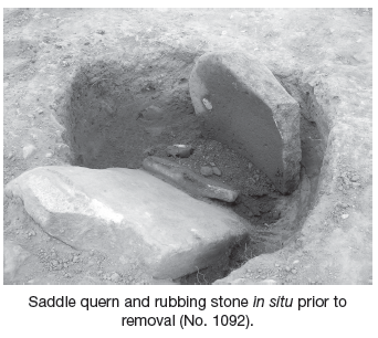
An additional four-post structure was located south of the line of post-holes, making a square ‘footprint’ with sides measuring 2–2.4m. This was a dense area of post- and stake-holes and may indicate several structures or perhaps amendments made to a single structure. A surface deposit of burnt bone was recorded adjacent to the structure, while a possible rectangular storage pit and a smaller circular pit, which contained a deposited quernstone, rubbing stone and pottery sherds, were also identified.
Area D
The westernmost area of the site revealed another structure. This consisted of four post-holes, making a square ‘footprint’ with sides measuring 3.1m. The post-holes have an average diameter of 0.5m and depths of 0.24–0.3m. These were surrounded by a circle of small post- and stake-holes, probably forming the external walls and enclosing an area of c. 25m2. Additional internal features and pits were also identified. The majority of these features contained several sherds of pottery and flint tools.
An additional smaller cluster of small post- and stake-holes may also have been structural, but no pattern has yet been established. Only one of these revealed pottery fragments.
Area E
Towards the southern limit of the site a shallow pit (measuring 2.3m by 1.2m and 0.2m deep) contained large amounts of pottery and flint. Several stake-holes were also identified in relation to the pit. A similar pit to the east may have been a possible rubbish pit and contained abundant amounts of charcoal and frequent flint flakes.
Area F
This area was located to the northern limit of the site. Several post-holes in this area may form an irregular structure with shallow slot-trenches. A leaf-shaped flint arrowhead was recovered from a slot-trench, while a few sherds of pottery and flint debitage were recovered from the post-holes. A line of fourteen small stake-holes running from south-east to north-west was located to the east of this area. Their average diameter is 0.15m and average depth 0.07m. A gap of 1.75m in this alignment may represent an entranceway in a line of stake fencing enclosing the area of domestic activity to the west.
Conclusion
A total of five structures were identified on the site, with a possible additional three structures, which are less obvious. Approximately 450 finds were recovered from secure contexts, including grooved ware pottery, a leaf-shaped flint arrowhead, convex flint scraper and a polished stone axe. These suggest a late Neolithic date for the site, but it is possible that a large Bronze Age element is also represented, from initial analysis of the ceramic finds.