2006:1089 - ROSSINAN, Kilkenny
County: Kilkenny
Site name: ROSSINAN
Sites and Monuments Record No.: 256887 121806
Licence number: A032/AR019, E2504
Author: Jonathan Monteith, for Valerie J. Keeley Ltd.
Author/Organisation Address: Brehon House, Kilkenny Road, Castlecomer, Co. Kilkenny
Site type: Kiln - corn-drying, Field boundary and Structure
Period/Dating: Multi-period
ITM: E 656468m, N 621278m
Latitude, Longitude (decimal degrees): 52.340204, -7.171333
This site was identified in the course of work carried out for Kilkenny County Council/National Roads Authority during the N9/N10 Waterford to Powerstown scheme. The site was identified during testing as a cobbled surface. Excavations were carried out in June and July 2006.
This site covered an area of c. 700m2 and was located in gradually sloping pasture, straddling an east–west field boundary. A ringfort (KK040–069) was located on the opposite side of this road, bisected by a field boundary, and is outside the area of the proposed development.
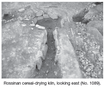
The earliest feature identified during excavation was that of a keyhole-shaped cereal-drying kiln consisting of a subcircular bowl with a concave base (measuring 1.75m long, 1.4m wide and 0.55m deep), with its long axis orientated north–south. This feature may be contemporary with the ringfort to the west. The kiln was slightly stepped in profile, with a lining of squared limestone boulders and flattened slabs along the edge. These had been placed on the step of the cut along the edges of the bowl and flue and had been fixed in place with a sandy clay material. This lining consisted of two courses of stone along the north-eastern edge of the bowl.
The curving flue extended downslope, west of the bowl, for a distance of c. 9m, with a maximum depth of 0.6m. This became very shallow and almost untraceable at its western terminus, where it curved slightly to the south-west. The stone lining continued along the length of the flue for several metres west of the bowl. The fire spot was identified at the western extent of the stone lining, where the flue was slightly wider. Here an area of oxidised soil was identified along the base of the flue. This area of intense in situ scorching indicates a substantial fire. The heat from this would have risen up the kiln to the drying chamber in the bowl of the cut, with temperatures controlled using the flue.
Several stratified layers were identified within the flue and the bowl. Within the bowl a primary layer of dark-brownish-black clay silt with frequent charcoal and pieces of burnt clay was identified on the base of the cut. This extended along the kiln flue for a distance of several metres. This layer probably represents the remnant material from the final use of the kiln. Initial specialist analysis of charred material from this fill has revealed at least two seed types. Two sherds of pottery were also recovered from this layer in the flue and initial analysis suggests an early medieval date. This layer was sealed by a series of backfill layers of stony sandy silt containing charcoal and frequent angular and sub-angular stones. The majority of the stone and charcoal content was concentrated in the bowl of the kiln, with the fill becoming more homogenous and sterile along the length of the flue.
Charcoal was retrieved and sampled from all contexts with securely sealed layers, while additional soil samples were taken for palaeobotanical analysis. It is hoped that these samples will provide additional information on the environment of the site and provide a date for these features.
Several north–south- and east–west-orientated linear features with compacted stone fills were of a later date. These may have had a drainage or plot division function. An area of compacted cobbled floor surface was also recorded, with a semicircular cobbled setting beside a small stone trough incorporated into the surface. A possible wall foundation was also identified. These features may be associated with a farmstead of late 19th-century date.