2006:1088 - RATHLOGAN (Sites AR51 and AR52), Kilkenny
County: Kilkenny
Site name: RATHLOGAN (Sites AR51 and AR52)
Sites and Monuments Record No.: N/A
Licence number: E002393
Author: Colum Hardy, for Valerie J. Keeley Ltd.
Author/Organisation Address: Brehon House, Kilkenny Road, Castlecomer, Co. Kilkenny
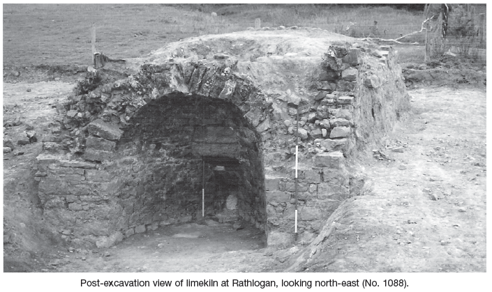
Site type: Kiln - lime and Pit
Period/Dating: Post Medieval (AD 1600-AD 1750)
ITM: E 631307m, N 669808m
Latitude, Longitude (decimal degrees): 52.778393, -7.535961
An excavation was carried out in September 2006, in advance of the construction of the M8/N8 Cullahill to Cashel road improvement scheme. Prior assessment and centreline test-trenching was carried out in 2005 by Colm Moriarty (Excavations 2005, No. 790, see A027/016). This site was north of Johnstown and east of Grangefertagh round tower and church.
AR51 was a conical stone-built limekiln. Limekilns usually date from the 18th century and were in use in some areas until the 1940s. An area of 600m2 was opened around the structure and modern rubbish and overburden had to be cleared from within the kiln. The structure measured 6.4–6.45m in length by 5.2m in width, with a maximum height of the frontal arch of 3.03m.
The most distinctive feature of the limekiln was the arch, in this case made of roughly hewn limestone (western side) with a square hole (púirín) at the base. The average height of the three sides was 1.8m each, with the walls 0.7–0.75m in width. The kiln was constructed on a clay base, 1.5–1.8m in depth, with occasional narrow deposits of angular limestone used as level foundations and the remains of 2–4 stone courses remaining in the walls. Large limestone and occasional granite blocks were mortared together and used in its construction. The blocks were faced to the exterior, with smaller irregular and rounded stones within the interior. Towards the back of the well-built stone-arched recess were five large rectangular slabs, which were used as a divide to the flue. The lowest one of these (púirín) had a semicircular notch (0.45m in width and 0.45m in depth) cut into its top to allow access to the base of the flue, probably to retrieve the lime and to control the draft of air into the fire. The vertical cylindrical cavity (flue), which was encased in clay and gravel, had a width of 2.5m at the top and narrowed to 0.4m at the base, with a maximum depth of 3.2m. It was cut through the clay foundation encased within the four walls of the limekiln. It was filled with modern farm waste. The coursing of the flue was very good at the top and bottom but very poor in the middle section, probably due to collapse and heat damage. Usually the interior of the flue is lined with fire clay and brick, but these were absent on excavation.
The front of the limekiln faced westwards and was badly damaged and, like the flue, was filled with rubbish. A clay-pipe stem fragment was recorded from the lower level on the floor of the arch. Modern pottery and blackware were the main finds recorded from the feature.
To the north of the limekiln was a curving cut feature, over 15m in length, c. 2.5m in width and 0.35m in depth. It was orientated east–west and filled with small to medium-sized rounded limestone. This feature may represent the raw material or waste material from the limekiln.
AR52 (231397 169845) was a small area, 100m to the north of AR51, subject to geophysics and testing in 2005. An isolated pit was resolved in testing and an additional area of 400m2 was stripped of topsoil, but no additional archaeological features were recorded.