2006:1050 - KILKEASY, Kilkenny
County: Kilkenny
Site name: KILKEASY
Sites and Monuments Record No.: N/A
Licence number: A032, AR043, E3014
Author: Jonathan Monteith, for Valerie J. Keeley Ltd.
Author/Organisation Address: Brehon House, Kilkenny Road, Castlecomer, Co. Kilkenny
Site type: House - Neolithic and Pit
Period/Dating: Neolithic (4000BC-2501 BC)
ITM: E 651947m, N 633096m
Latitude, Longitude (decimal degrees): 52.446861, -7.235839
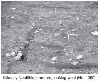
This site was identified in the course of work carried out for Kilkenny County Council/National Roads Authority during the N9/N10 Waterford to Powerstown scheme. The site was located in gently, west-sloping boggy pasture. An area of c. 1050m2 was excavated in October and November 2006.
Neolithic structure
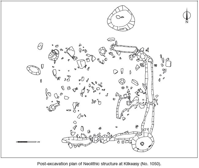
A Neolithic structure was identified composed of three slot-trenches and shallow post-holes enclosing an internal area of c. 30m2. Rather than a continuous slot, the trenches were individually cut with a maximum depth of 0.2m. The eastern wall trench, orientated north–south, was 4m in length. This slot curved slightly to the north-west and terminated to the north in a slightly deeper area that may constitute a post-hole. Its southern terminus similarly curved slightly south-west and was associated with a deep post-pit, with a deeper post-hole in the base. A similar pit was identified to the north of the structure and may be contemporary, forming a similar, probably structural, function.
The southern wall trench was also associated with this post-pit. It was orientated east–west and became very shallow at its western extent. The northern wall trench similarly became very shallow and appeared to terminate beside a deeper post-hole. No evidence of a western wall trench was identified. Instead a series of three possible post-holes may have constituted the western wall.
The interior of the structure was irregular with frequent outcropping stone from the natural subsoil. No trace of an interior surface was identified; however, three internal pits on the eastern half of the house were recorded. On the eastern external side an external pit may represent a contemporary hearth. Several pits to the south may also be associated with this structure.
Neolithic pits
Approximately 20m to the north of the structure a series of pits were identified. Nine pits were clustered together, some with stake-holes located in their bases. The fills of these pits were very similar and were characterised by dense areas of charcoal, including charred seeds and hazelnut shells. Several sherds of pottery, as well as a plano-convex stone axe, a polished stone perforated ‘pendant’, worked flint and possible stone axe rough-outs, were also recovered from secure contexts within these pits.
Between this area and the structure to the south, a linear pit and several other intercutting features were recorded. These may have been contemporary with the Neolithic structure; however, no direct stratigraphic relationship could be determined. Some of these features may have been storage pits or functioned as structural elements.
The range of finds and architecture of the structure suggest a Neolithic date for the site. This has been corroborated by initial analysis of pottery, which suggests an Early Neolithic date (E. Grogan, pers. comm.).